Related Research Articles
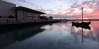
Geraldton is a coastal city in the Mid West region of the Australian state of Western Australia, 424 kilometres (263 mi) north of the state capital, Perth.

North West Coastal Highway is a generally north-south Western Australian highway which links the coastal city of Geraldton with the town of Port Hedland. The 1,300-kilometre-long (808 mi) road, constructed as a sealed two-lane single carriageway, travels through remote and largely arid landscapes. Carnarvon is the only large settlement on the highway, and is an oasis within the harsh surrounding environment. The entire highway is allocated National Route 1, part of Australia's Highway 1, and parts of the highway are included in tourist routes Batavia Coast Tourist Way and Cossack Tourist Way. Economically, North West Coastal Highway is an important link to the Mid West, Gascoyne and Pilbara regions, supporting the agricultural, pastoral, fishing, and tourism industries, as well as mining and offshore oil and gas production.

Northampton is a town 52 kilometres (32 mi) north of Geraldton, in the Mid West region of Western Australia. At the 2011 census, the town had a population of 868. The town contains a National Trust building. The town lies on the North West Coastal Highway. Originally called The Mines, Northampton was gazetted in 1864 and named after the colony's Governor, John Hampton. The town was sited in the Nokanena Brook valley, between the hamlets around the two major copper mines in the area, the Wanerenooka and the Gwalla.

The Murchison River is the second longest river in Western Australia. It flows for about 820 km (510 mi) from the southern edge of the Robinson Ranges to the Indian Ocean at Kalbarri. The Murchison-Yalgar-Hope river system is the longest river system in Western Australia. It has a mean annual flow of 208 gigalitres, although in 2006, the peak year on record since 1967, flow was 1,806 gigalitres.

John Nicol Drummond (1816–1906) was an early settler in Western Australia. He became the colony's first 'Inspector of Native Police', and helped to explore the Champion Bay district before becoming one of the district's pioneer pastoralists.
The Greenough River is a river in the Mid West region of Western Australia.

The City of Geraldton-Greenough was a local government area in the Mid West region of Western Australia, 424 kilometres (263 mi) north of the state capital, Perth on the Indian Ocean. It covered an area of 1,798.3 square kilometres (694.3 sq mi), and its seat of government was the town of Geraldton.
Hill River is a river in the Wheatbelt region of Western Australia.
Drummond Cove is a coastal town located 12 kilometres (7 mi) north of Geraldton, Western Australia in the local government area of the City of Greater Geraldton. The locality was gazetted in 1985.

Chapman River is a river in the Mid West region of Western Australia.
The Arrowsmith River lies within the Mid West region of Western Australia.

The Irwin River is a river in the Mid West of Western Australia. It was named on 9 April 1839 by the explorer George Grey, while on his second disastrous exploration expedition along the Western Australian coast, after his friend Major Frederick Irwin, the Commandant of the Swan River settlement, and later acting Governor of Western Australia from 1847 to 1848.
Hutt River is a river in the Mid West region of Western Australia.

Drysdale River is a river in the Kimberley region of Western Australia.

Hutt Lagoon is a marine salt lake located near the Indian Ocean coast 2 kilometres (1.2 mi) north of the mouth of the Hutt River, in the Mid West region of Western Australia.
The Bowes River is a river in the Mid West of Western Australia. It was named on 6 April 1839 by the explorer George Grey while on his second exploration expedition along the Western Australian coast. It was named for Mary Bowes, Dowager Countess of Strathmore, the wife of Sir William Hutt. Hutt was a British Liberal politician who was heavily involved in the colonization of New Zealand and South Australia, and the brother of John Hutt, the second governor of Western Australia. Sir William Hutt was a member of the 1836 select committee on Disposal of Lands in the British Colonies. Grey named the nearby Hutt River after Hutt.
The Nambung River is a river in the Wheatbelt region of Western Australia, 170 kilometres (106 mi) north of Perth. The river drains an area between the towns of Cervantes and Badgingarra. In its lower reaches the Nambung River forms a chain of waterholes in the Nambung Wetlands where it disappears underground into a limestone karst system 5.5 kilometres (3 mi) from the Indian Ocean.
Champion Bay is a coastal feature north of Geraldton, Western Australia, facing the port and city between Point Moore and Bluff Point.

The City of Greater Geraldton is a local government area in the Mid West region of Western Australia, 424 kilometres (263 mi) north of the state capital, Perth on the Indian Ocean. It covers an area of 12,625.5 square kilometres (4,874.7 sq mi), and its seat of government is the town of Geraldton.
White Peak Station, also known as White Peak Homestead, is a property situated in the Shire of Chapman Valley approximately 16 kilometres (10 mi) north north east of Geraldton in the Mid West region of Western Australia. The White Peak Homestead was one of the five original pastoral leases established in the region. It was settled by John Drummond, a pioneer pastoralist. The homestead and surroundings retain the homestead building, which is notable for its large scale and grand detailing in comparison with other farmhouses in the region. Outbuildings including stone stables, tack room, shearing shed, machinery sheds are still in place, although some original stone walls have been demolished.
References
- ↑ "Total Annual Discharge report: Site 701006 Buller River". Water Resources Data - Streamflow Sites. Government of Western Australia Department of Water. 20 July 2012. Archived from the original on 7 April 2011. Retrieved 20 July 2012.
- ↑ "Site Summary Report: Site 701006 Buller River". Water Resources Data - Streamflow Sites. Government of Western Australia Department of Water. 20 July 2012. Archived from the original on 7 April 2011. Retrieved 20 July 2012.
- ↑ Grey, George (1841). Journals of two expeditions of discovery in North-West and Western Australia, during the years 1837, 38, and 39, describing many newly discovered, important, and fertile districts, with observations on the moral and physical condition of the aboriginal inhabitants, etc. etc. 2. London: T. and W. Boone. p. 26. Retrieved 17 March 2012.
- ↑ "Latest English News: New Colony". The Sydney Herald. 30 October 1834. p. 1. Retrieved 25 July 2012.
- ↑ "The Inquirer". 24 January 1844. p. 2. Retrieved 25 July 2012.
- ↑ Temple, Philip (2002). A Sort of Conscience: The Wakefields. Auckland: Auckland University Press. p. 386. ISBN 978-1869403072 . Retrieved 11 April 2012.
Coordinates: 28°38′11″S114°36′18″E / 28.63639°S 114.60500°E
Rivers of Western Australia | |
|---|---|
| Rivers of the Gascoyne region | |
| Rivers of the Goldfields-Esperance region | |
| Rivers of the Great Southern region | |
| Rivers of the Kimberley region |
|
| Rivers of the Mid West region | |
| Rivers of the Peel and Perth regions | |
| Rivers of the Pilbara region | |
| Rivers of the South West region | |
| Rivers of the Wheatbelt region | |
| This article related to a river in Western Australia is a stub. You can help Wikipedia by expanding it. |