Frankland River (Western Australia)

Last updated

Frankland
Nyungar: Kwakoorillup
Circular Pool.jpg
Circular pool in the Frankland River
Australia Western Australia relief location map.png
Red pog.svg
Location of the river mouth in Western Australia
Location
Country Australia
State Western Australia
Region Great Southern
Physical characteristics
Source confluenceTowerlup Brook and Ornabullup Creek
  locationTrollup Hill
  coordinates 34°10′24″S117°0′17″E / 34.17333°S 117.00472°E / -34.17333; 117.00472
  elevation215 m (705 ft)
Mouth Nornalup Inlet
  location
west of Walpole
  coordinates
34°59′53″S116°45′00″E / 34.99806°S 116.75000°E / -34.99806; 116.75000
Length162 km (101 mi)
Basin size5,722 km2 (2,209 sq mi)
Discharge 
  location river mouth
  average17.7 m3/s (630 cu ft/s)
Basin features
Tributaries 
  left Gordon River
National park Walpole-Nornalup
[1] [2] [3]

The Frankland River is a river in the Great Southern region of Western Australia. The Frankland River is the largest river by volume in the region and the eighth largest in the state. [4] The traditional owners of the area are the Menang Noongar people, who know the river as Kwakoorillup, meaning "place of quokka". [5]

Contents

Location and features

Mt Frankland was given its modern name in December 1829 by naval ship's surgeon Thomas Braidwood Wilson after the Surveyor General of Van Diemen's Land George Frankland. Wilson explored the area in company with the Noongar Mokare from King George Sound, John Kent (officer in charge of the Commissariat at Frederick Town, King George Sound), two convicts and Private William Gough of the 39th Regiment, while his ship the Governor Phillip was being repaired at King George Sound. [6] [7] The river was sighted by Captain Thomas Bannister in January 1831, and was named by Governor James Stirling when Bannister reported its existence to him. [8] Stirling's choice was influenced by Wilson's naming of Mt Frankland. The Frankland was apparently previously known by sealers as the Deep River. [1]

The Gordon River, a tributary of the Frankland River, has its source south-west of the town of Broomehill. The other two smaller tributaries are Towerlup Brook and Ornabullup Creek. The Walpole, the Deep and the Frankland all flow into the Nornalup Inlet west of Walpole.

85% of the Frankland River's catchment, mostly about the 800 millimetres (31 in) rainfall isohyet, is cleared for agriculture. The main land uses are cereal cropping and sheep grazing, with minor dairy farming, agroforestry, viticulture and olive farming. [9]

Salinity has increased in the river system with average values of 2 parts per thousand in the 1970s to 1980s to 30 ppt since 2000.

See also

Related Research Articles

<span class="mw-page-title-main">Mount Frankland National Park</span> Protected area in Western Australia

Mount Frankland National Park is a national park in the South West region of Western Australia, 327 km (203 mi) south of Perth. The park is part of the larger Walpole Wilderness Area that was established in 2004, an international biodiversity hotspot.

<span class="mw-page-title-main">Albany, Western Australia</span> City in Western Australia

Albany is a port city in the Great Southern region in the Australian state of Western Australia, 418 kilometres (260 mi) southeast of Perth, the state capital. The city centre is at the northern edge of Princess Royal Harbour, which is a part of King George Sound. The central business district is bounded by Mount Clarence to the east and Mount Melville to the west. The city is in the local government area of the City of Albany. While it is the oldest colonial, although not European, settlement in Western Australia - predating Perth and Fremantle by over two years - it was a semi-exclave of New South Wales for over four years until it was made part of the Swan River Colony.

The Swan River Colony, also known as the Swan River Settlement, or just Swan River, was a British colony established in 1829 on the Swan River, in Western Australia. This initial settlement place on the Swan River was soon named Perth, and it became the capital city of Western Australia.

<span class="mw-page-title-main">Mount Barker, Western Australia</span> Town in Western Australia

Mount Barker is a town on Albany Highway and the administrative centre of the Shire of Plantagenet in the Great Southern region of Western Australia. At the 2021 census, Mount Barker had a population of 2,855.

<span class="mw-page-title-main">Stirling Range</span> Mountain range in Great Southern region of Western Australia

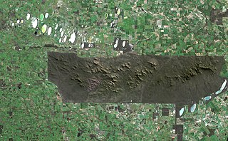
The Stirling Range or Koikyennuruff is a range of mountains and hills in the Great Southern region of Western Australia, 337 kilometres (209 mi) south-east of Perth. It is over 60 kilometres (37 mi) wide from west to east, stretching from the highway between Mount Barker and Cranbrook eastward past Gnowangerup. The Stirling Range is protected by the Stirling Range National Park, which was gazetted in 1913, and has an area of 1,159 km2 (447 sq mi).

<span class="mw-page-title-main">King George Sound (Western Australia)</span> Large body of water in southern Western Australia

King George Sound is a sound on the south coast of Western Australia. Named King George the Third's Sound in 1791, it was referred to as King George's Sound from 1805. The name "King George Sound" gradually came into use from about 1934, prompted by new Admiralty charts supporting the intention to eliminate the possessive 's' from geographical names.

<span class="mw-page-title-main">Denmark, Western Australia</span> Coastal town in Western Australia

Denmark is a coastal town located on Wilson Inlet in the Great Southern region of Western Australia, 423 kilometres (263 mi) south-south-east of the state capital of Perth. At the 2016 census, Denmark had a population of 2,558; however, the population can be several times the base population during tourist seasons.

<span class="mw-page-title-main">Williams, Western Australia</span> Town in the Wheatbelt, Western Australia

Williams is a town located in the Wheatbelt region of Western Australia, 161 kilometres (100 mi) south-southeast of the state capital, Perth along Albany Highway and 32 kilometres (20 mi) west of Narrogin. The Williams River passes through the town. At the 2016 census, Williams had a population of 411.

<span class="mw-page-title-main">Robert Dale</span> English army officer and explorer

Lieutenant Robert Dale was the first European explorer to cross the Darling Range in Western Australia.

<span class="mw-page-title-main">Thomas Braidwood Wilson</span> Australian surgeon and explorer (1792–1843)

Thomas Braidwood Wilson FRGS was an Australian surgeon and explorer. He was baptised in Kirknewton, West Lothian, Scotland, the son of James, and Catherine Boak.

Frankland River is a small town in the Great Southern region of Western Australia. The town is in the shire of Cranbrook and is situated approximately 332.7 km (206.7 mi) from the state's capital, Perth, approximately 120 km (75 mi) north west of Albany, 83 km (52 mi) southwest of Kojonup, 19 km (12 mi) north of Rocky Gully and 90 km (56 mi) east of Manjimup. Frankland derives its name from its location 6 km east of the Frankland River. At the 2006 census, Frankland had a population of 380.

<span class="mw-page-title-main">Murray River (Western Australia)</span> River in Peel region of Western Australia

The Murray River is a river in the southwest of Western Australia. It played a significant part in the expansion of settlement in the area south of Perth after the arrival of British settlers at the Swan River Colony in 1829. It should not be confused with the Murray River in southeastern Australia, which is the longest river in the country.

<span class="mw-page-title-main">Nornalup Inlet</span> Inlet on southern coast of Western Australia

Nornalup Inlet is an estuarine body of water on the south coast of the South West of Australia, approximately 450 km (280 mi) from Perth.

<span class="mw-page-title-main">King River (Great Southern, Western Australia)</span> River in Western Australia

The King River is a river in the Great Southern region of Western Australia.

<span class="mw-page-title-main">Mokare</span>

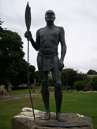
Mokare was a Noongar Aboriginal man from the south-west corner of Australia, who was pivotal in aiding European exploration of the area.

<span class="mw-page-title-main">Hay River (Western Australia)</span> River in Western Australia

The Hay River is a river in the Great Southern region of Western Australia. The traditional owners of the area are the Noongar people, who know the river as Genulup.

The Walpole River is a river in the Great Southern region of Western Australia. The river was seen by Captain Thomas Bannister in 1831 and named by Governor James Stirling after Captain W. Walpole.

<span class="mw-page-title-main">Denmark River</span> River in Western Australia

The Denmark River is located in the Great Southern region of Western Australia. The river rises near Pardelup and meanders in a southerly direction until it flows through Denmark into Wilson Inlet. The traditional owners of the area are the Noongar people, who know the river as Kwoorabup, meaning the place of the Western brush wallaby.

Thomas Bannister (1799–1874) was a soldier and explorer in Western Australia. He was born in Steyning, Sussex in 1799, and arrived in Western Australia in 1829, age 30, with the rank of Captain aboard the Atwick with 3 servants from London, England.

Mount Roe National Park is a national park in the Great Southern Region of Western Australia. It was designated in 2004, and covers an area of 1278 km2.

References

  1. 1 2 "History of river names – F". Western Australian Land Information Authority. Archived from the original on 19 April 2021. Retrieved 4 August 2008.
  2. "Map of Frankland River, WA". Bonzle Digital Atlas. 2008. Retrieved 24 November 2008.
  3. "South Coast River Care - Frankland". 2007. Archived from the original on 28 September 2007. Retrieved 1 August 2007.
  4. "Waterways WA - Strategies for Management to WA waterways" (PDF). 2001. Archived from the original (PDF) on 1 September 2007. Retrieved 1 August 2007.
  5. "Dual Naming Project" (PDF). Shire of Denmark . Retrieved 3 June 2017.
  6. Wilson, Thomas Braidwood (1835). Narrative of a Voyage Round the World. London: Sherwood Gilbert & Piper.
  7. Wilson, Thomas Braidwood (1833), "Extract of a letter received from Dr J.B. Wilson, R.N., dated King George's Sound, 15th December, 1829", in Cross, Joseph (ed.), Journals of Several Expeditions Made in Western Australia During the Years 1829, 1830, 1831 and 1832: Under the Sanction of the Governor, Sir James Stirling, London: J. Cross, p. 21
  8. Bannister, Thomas (1833), "A Report of Captain Bannister's Journey to King George's Sound, over Land, February 5th, 1831", in Cross, Joseph (ed.), Journals of Several Expeditions Made in Western Australia During the Years 1829, 1830, 1831 and 1832: Under the Sanction of the Governor, Sir James Stirling, London: J. Cross, p. 107
  9. MacCallum, Catherine (September 2004). "Landuse and tenure". Gordon-Frankland Catchment Compendium (pdf). Perth: Department of Environment. p. 1:11. ISBN   1-920947-39-6 . Retrieved 14 August 2014.