Western Australia is a state of Australia occupying the western third of the land area of Australia, excluding external territories. It is bounded by the Indian Ocean to the north and west, the Southern Ocean to the south, the Northern Territory to the north-east, and South Australia to the south-east. Western Australia is Australia's largest state, with a total land area of 2,527,013 square kilometres (975,685 sq mi). It is the second-largest country subdivision in the world, surpassed only by Russia's Sakha Republic. As of 2021, the state has 2.76 million inhabitants—11 percent of the national total. The vast majority live in the south-west corner; 79 percent of the population lives in the Perth area, leaving the remainder of the state sparsely populated.
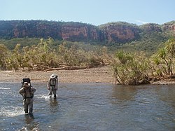
The Kimberley is the northernmost of the nine regions of Western Australia. It is bordered on the west by the Indian Ocean, on the north by the Timor Sea, on the south by the Great Sandy and Tanami deserts in the region of the Pilbara, and on the east by the Northern Territory.

The Gwion Gwion rock paintings, Gwion figures, Kiro Kiro or Kujon are one of the two major regional traditions of rock art found in the north-west Kimberley region of Western Australia. Key traditional owners have published their own account of the meaning of the images. However the identity of the artists and the age of the art are contended within archaeology and amongst Australian rock art researchers. A 2020 study estimates that most of the anthropomorphic figures were created 12,000 years ago, based on analysis of painted-over wasps' nests. These aspects have been debated since the works were seen, and recorded, in 1891 by pastoralist Joseph Bradshaw, after whom they were named until recent decades. As the Kimberley is home to many traditional owners, the rock art is referred to and known by many different names in the local languages, the most common of which are Gwion Gwion or Kiro Kiro/Giro Giro. The art consists primarily of human figures ornamented with accessories such as bags, tassels and headdresses.

The Murchison River is the second longest river in Western Australia. It flows for about 820 km (510 mi) from the southern edge of the Robinson Ranges to the Indian Ocean at Kalbarri. The Murchison-Yalgar-Hope river system is the longest river system in Western Australia. It has a mean annual flow of 208 gigalitres, although in 2006, the peak year on record since 1967, flow was 1,806 gigalitres.

The Blackwood River is a major river and catchment in the South West of Western Australia.

The Fitzroy River, also known as Martuwarra, is located in the West Kimberley region of Western Australia. It has 20 tributaries and its catchment occupies an area of 93,829 square kilometres (36,228 sq mi), within the Canning Basin and the Timor Sea drainage division.

Wyndham is the northernmost town in the Kimberley region of Western Australia, 3,315 kilometres (2,060 mi) northeast of Perth via the Great Northern Highway. It was established in 1886 to service a new goldfield at Halls Creek, and it is now a port and service centre for the east Kimberley with a population of 941 as of the 2021 census. Aboriginal and Torres Strait Islander people make up 54% of the population. Wyndham comprises two areas - the original town site at Wyndham Port situated on Cambridge Gulf, and 5 kilometres (3.1 mi) by road to the south, the Three Mile area with the residential and shopping area for the port, also founded in 1886. Wyndham is part of the Shire of Wyndham-East Kimberley.

The Dale River is a perennial river located in the Wheatbelt region of Western Australia.

The Irwin River is a river in the Mid West region of Western Australia. It was named on 9 April 1839 by the explorer George Grey, while on his second disastrous exploration expedition along the Western Australian coast, after his friend Major Frederick Irwin, the Commandant of the Swan River settlement, and later acting Governor of Western Australia from 1847 to 1848.

Drysdale River is a river in the Kimberley region of Western Australia.

The King Edward River is a river in the Kimberley region of Western Australia.

The Prince Regent River is a river in the Kimberley region of Western Australia.
Louisa Downs, also commonly just referred to as "Louisa", is a large cattle station midway between Fitzroy Crossing and Halls Creek in the Kimberley region in Western Australia.
Earthquakes have occurred in Western Australia (WA) on a regular basis throughout its geological history.
Drysdale River Station is a pastoral lease that operates as a cattle station in Western Australia.

Parnngurr is a medium-sized Aboriginal community, located 370 km from Newman in the Pilbara region of Western Australia, within the Shire of East Pilbara. Parnngurr was originally known as Cotton Creek, the name of the ephemeral creek that runs beside the community.
Moorarie Station is a pastoral lease currently operating as a sheep station in the Murchison district of Western Australia's Mid West region.
Joseph Bradshaw was a pastoralist in Western Australia and then the Northern Territory.

Mount Elizabeth Station is a pastoral lease that operates as a cattle station in Western Australia.