Related Research Articles

Lesueur National Park is a national park straddling the boundary between the Wheatbelt and Mid West regions of Western Australia, 211 km north of Perth. The park was gazetted in 1992. It includes two mesas known as Mount Lesueur and Mount Michaud, and supports a highly diverse flora.

The Condamine River, part of the Balonne catchment that is part of the Murray-Darling Basin, drains the northern portion of the Darling Downs, an area of sub-coastal southern Queensland, Australia. The river is approximately 500 kilometers (310 mi) long and rises on Mount Superbus, South East Queensland's highest peak, on the western slopes of the Great Dividing Range, approximately 100 kilometres (62 mi) from the east coast of Queensland, and then flows north west across the Darling Downs, then west. The Condamine River is a tributary of the Darling River.
Sir William Hutt, KCB, PC was a British Liberal politician who was heavily involved in the colonisation of New Zealand and South Australia.

The Murchison River is the second longest river in Western Australia. It flows for about 820 km (510 mi) from the southern edge of the Robinson Ranges to the Indian Ocean at Kalbarri. The Murchison-Yalgar-Hope river system is the longest river system in Western Australia. It has a mean annual flow of 208 gigalitres, although in 2006, the peak year on record since 1967, flow was 1,806 gigalitres.
Leigh Creek is a former coal-mining town in eastern central South Australia. At the 2016 census, Leigh Creek had a population of 245, a 55% decrease from 550 in the previous census in 2011.
The Hutt River is a river located in the Mid North and Clare Valley regions of the Australian state of South Australia.
Moore River (Garban) is a river in the Wheatbelt region of Western Australia.
The Greenough River is a river in the Mid West region of Western Australia.

Chapman River is a river in the Mid West region of Western Australia.
The Arrowsmith River lies within the Mid West region of Western Australia.
Hutt River is a river in the Mid West region of Western Australia.

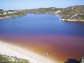
Hutt Lagoon is a marine salt lake located near the Indian Ocean coast 2 kilometres (1.2 mi) north of the mouth of the Hutt River, in the Mid West region of Western Australia.

Hornaday River is a waterway located above the Arctic Circle on the mainland of Northern Canada.
The Bowes River is a river in the Mid West region of Western Australia. It was named on 6 April 1839 by the explorer George Grey while on his second exploration expedition along the Western Australian coast. It was named for Mary Bowes, Dowager Countess of Strathmore, the wife of Sir William Hutt. Hutt was a British Liberal politician who was heavily involved in the colonization of New Zealand and South Australia, and the brother of John Hutt, the second governor of Western Australia. Sir William Hutt was a member of the 1836 select committee on Disposal of Lands in the British Colonies. Grey named the nearby Hutt River after Hutt.
The Nambung River is a river in the Wheatbelt region of Western Australia, 170 kilometres (106 mi) north of Perth. The river drains an area between the towns of Cervantes and Badgingarra. In its lower reaches the Nambung River forms a chain of waterholes in the Nambung Wetlands where it disappears underground into a limestone karst system 5.5 kilometres (3 mi) from the Indian Ocean.
The Wakefield River is an ephemeral river that flows to an estuary in the Australian state of South Australia.
The Buller River is a river in the Mid West region of Western Australia, near Geraldton.

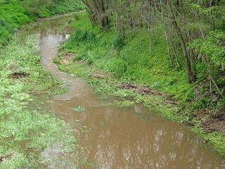
The Hill River is an ephemeral river located in the Mid North region of the Australian state of South Australia.
John Hill was an English explorer of South Australia and part of the European exploration of Australia. Hill was the first European to see and traverse the Clare Valley.

Waggener Magisterial District is one of ten magisterial districts in Mason County, West Virginia, United States. The district was originally established as a civil township in 1863, and converted into a magisterial district in 1872. In 2020, Waggener District was home to 2,483 people.
References
- ↑ "Bonzle Digital Atlas – Map of Hill River". 2009. Retrieved 12 July 2016.
- ↑ "Ribbons of Blue - Mid West Region". 2008. Archived from the original on 31 May 2009. Retrieved 12 March 2009.
- 1 2 Grey, George (1841). Journals of two expeditions of discovery in North-West and Western Australia, during the years 1837, 38, and 39, describing many newly discovered, important, and fertile districts, with observations on the moral and physical condition of the aboriginal inhabitants, etc. etc. Vol. 2. London: T. and W. Boone. p. 263. Retrieved 17 March 2012.
- ↑ "History of river names – H". Western Australian Land Information Authority. Archived from the original on 19 April 2021. Retrieved 31 July 2012.
- ↑ "The foundation of South Australia". South Australian Register . 11 September 1869. p. 2. Retrieved 1 August 2012.
- ↑ "Grey, Sir George (1812–1898)". Australian Dictionary of Biography. National Centre of Biography, Australian National University. Retrieved 25 August 2011.
- ↑ Hill River project : notice of intent, [Canning Resources], 1989, retrieved 10 October 2023
- ↑ The Hill River project : environmental review and management programme, coal mine and coal-fired power station : draft environmental impact statement : coal-fired power station, Canning Resources, 1990, retrieved 10 October 2023
- ↑ "IN BRIEF - Mines now in national park in WA". The Canberra Times . Vol. 65, no. 20, 445. Australian Capital Territory, Australia. 4 April 1991. p. 11. Retrieved 10 October 2023– via National Library of Australia.