| Minilya | |
|---|---|
| Etymology | Aboriginal: meaning unknown |
| Location | |
| Country | Australia |
| State | Western Australia |
| Region | Gascoyne |
| Physical characteristics | |
| Source | Black Range (Western Australia) |
| • coordinates | 23°57′53″S115°27′11″E / 23.96472°S 115.45306°E |
| • elevation | 275 m (902 ft) |
| Mouth | Lake MacLeod |
• coordinates | 23°56′37″S113°51′25″E / 23.94361°S 113.85694°E Coordinates: 23°56′37″S113°51′25″E / 23.94361°S 113.85694°E |
• elevation | 0 m (0 ft) |
| Length | 269 km (167 mi) |
| Basin size | 52,662 km2 (20,333 sq mi) |
| Discharge | |
| • location | mouth |
| • average | 44,847 m3/s (1,583,800 cu ft/s) |
| [1] [2] [3] [4] | |
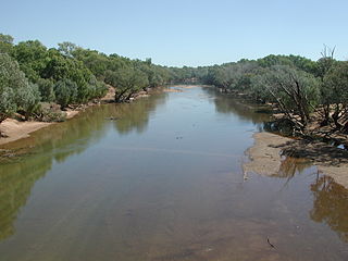
The Minilya River is a river in the Gascoyne region of Western Australia.
The headwaters of the river rise in the south-west of the Black Range and flows in a generally westerly direction, joined by three minor tributaries: Minilya River South, Bee Well Creek and Naughton Creek. The river is crossed by the North West Coastal Highway near the Minilya Roadhouse and then later discharges into Lake MacLeod. The area is semi-arid with a landscape of woodland and scrub used for sheep and cattle grazing. The Minilya River descends 278 metres (912 ft) over its 269-kilometre (167 mi) course. [2]
The name of the river is Aboriginal in origin but its meaning is unknown. The first Europeans to visit the river were the explorers who named it, Charles Brockman and George Hamersley, who visited the area in 1876. [1] Brockman and Hamersley also named the Lyndon River and Brockman later took up a 40,000 acres (16,187 ha) lease known as Boolathana then another property, Minilya Station. [5]
The traditional owners of the area are the Tharrkari and Baiyungu peoples. [6]
The soils throughout the river basin are eroded and the regional ecology is degraded as a result of cattle grazing from the numerous pastoral stations found through the area. As a result, fencing has been installed through the length of the river, water tanks and troughs installed and establishment of new grazing yards. [7]
The Minilya is prone to occasional flooding following heavy rain events as it did in 1905. [8] More flooding occurred 1918 when Minilya Station recorded 7.58 inches (193 mm) in just over two months isolating the homestead. [9] Further flooding occurred in 1942 with many station homesteads being left isolated. [10]

Minilya is a location in Western Australia north of Carnarvon on the North West Coastal Highway. It is at a junction in the North West Coastal Highway, where the turn off to Exmouth is 220 kilometres (140 mi) from that location. The main highway then continues to the next junction 217 kilometres further, at Nanutarra Roadhouse.

The Gascoyne River is a river in the Gascoyne region of Western Australia. At 865 kilometres (537 mi), it is the longest river in Western Australia.
Boolardy Station is a remote former sheep and cattle station in the Mid West (Murchison) region of Western Australia, about 194 km (121 mi) north-north-east of Pindar and 200 km (120 mi) west-south-west of Meekatharra. It is within the Shire of Murchison and situated on pastoral lease no. 3114/406. The area of the lease is 3,467.48 square kilometres (1,338.80 sq mi).

The 2010 Gascoyne River flood was regarded as the most severe flood to take place along the Gascoyne River in Western Australia on record. Triggered by record-breaking rainfall, amounting to over 6,000 percent of the monthly mean, 313.6 mm (12.35 in) and 5 mm (0.20 in) respectively, in just four days, the floods caused widespread damage in the region. By 17 December, the river began to rise in response to the heavy rains, eventually exceeding its banks within two days. Water levels reached record values at three stations along the river, cresting at 15.53 m (51.0 ft) near Fishy Pool. Evacuation orders were issued for several towns affected by rising waters. The most substantial impact was felt in Carnarvon where entire homes were washed away. Following the disaster, emergency supplies and funds were distributed to affected residents to aid them in restoring their livelihoods. Though no people died in the event, an estimated two thousand head of cattle perished and damage was estimated at A$100 million.

Yardie Creek, or Yardie Creek Station, is a pastoral lease and sheep station located in the Gascoyne region of Western Australia. It is situated approximately 12.5 kilometres (8 mi) west north west of Exmouth and 143 kilometres (89 mi) north of Coral Bay.
Sherlock Station is a pastoral lease and sheep station located approximately 54 kilometres (34 mi) East of Roebourne in the Pilbara region of Western Australia. Covering an area of 216,700 acres (87,695 ha) pasture, the lease provides good grazing land. In 2015 it was purchased by Bettini Bros, now Bettini Beef, in a package with Mallina and Pyramid Stations. The Bettinis still owned the lease in 2018. Sherlock is operating under the Crown Lease number CL311-1966 and has the Land Act number LA3114/558.
Croydon Station, often spelt as Croyden Station, is a pastoral lease and sheep station.
Yeeda Station is a pastoral lease that operates as a cattle station in the Kimberley region of Western Australia.
Jimba Jimba Station, most often referred to as Jimba Jimba, is a pastoral lease currently operating as a cattle station in Western Australia, that once operated as a sheep station.
Minilya Station, most often referred to as Minilya, is a pastoral lease currently operating as a cattle station that once operated as a sheep station in the Gascoyne region of Western Australia.
Boolathana Station is a pastoral lease currently operating as a cattle station that once operated as a sheep station in Western Australia.
Mount Clere Station is a pastoral lease that once operated as a sheep station but currently operates as a cattle station in Western Australia.
Charles Samuel Brockman was a prominent explorer and pastoralist in the Gascoyne region of Western Australia.
Brickhouse Station, formerly spelt Brick House Station, is a pastoral lease in Western Australia. It once operated as a sheep station but now operates as a cattle station, with some 90 ha turned over to mango cultivation.

Warroora or Warroora Station is a pastoral lease that once operated as a sheep station and is now operating as a cattle station in the Gascoyne region of Western Australia. The property offers eco friendly accommodation to tourists with visitors able to stay in the old homestead, shearers' quarters or camping near the beach.
George Julius Brockman was a prominent explorer and pastoralist in the Gascoyne and Kimberley regions of Western Australia.
Middalya Station is a pastoral lease that operates as a sheep station in Western Australia.

Bidgemia Station, commonly referred to as Bidgemia, is a pastoral lease that operates as a cattle station in Western Australia.
Callagiddy Station, commonly referred to as Callagiddy, is a pastoral lease that operates as a cattle station in the Gascoyne region of Western Australia. The name Callagiddy is a Kimberly name picked up on a droving trip by the original owner Dansy Powell. It means, like many Aboriginal place names, "plenty water" and is pronounced with a hard G (J). Why the name Callagiddy was significant to Powell is unknown, however he named his seventh child, "Amy Callagiddy Powell". The original homestead on Callagiddy was located in the north-east section of the property known today as "Old Callagiddy". It was later relocated "lock, stock and barrel" to the centre of the property, when the lease was expanded in 1918, where it stands today. It is situated about 41 kilometres (25 mi) south east of Carnarvon, 109 kilometres (68 mi) north east of Denham and 26 kilometres (16 mi) east of Great Northern Highway. On the north and west boundary is Brick House Station, north-east boundary Meeragoolia station, eastern boundary Ella Valla Station and southern boundary Edagee Station. The Gascoyne River is 30 kilometres (19 mi) north of the northern boundary and the coast 12.5 kilometres (7.8 mi) west of the western boundary. The long term average rainfall is 214 mm and the median average is 194 mm.
Glenflorrie Station, also known as Glen Florrie Station, is a pastoral lease that operates as a cattle station. It is located about 147 kilometres (91 mi) south of Pannawonica and 175 kilometres (109 mi) west of Paraburdoo in the Pilbara region of Western Australia, and occupies an area of 1,970 square kilometres (761 sq mi).
Rivers of Western Australia | |
|---|---|
| Rivers of the Gascoyne region | |
| Rivers of the Goldfields-Esperance region | |
| Rivers of the Great Southern region | |
| Rivers of the Kimberley region |
|
| Rivers of the Mid West region | |
| Rivers of the Peel and Perth regions | |
| Rivers of the Pilbara region | |
| Rivers of the South West region | |
| Rivers of the Wheatbelt region | |