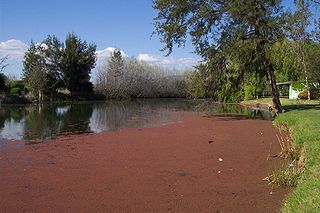
Cudgegong River, a perennial stream that is part of the Macquarie catchment within the Murray-Darling basin, is located in the central western and Orana districts of New South Wales, Australia.

The Ovens River, a perennial river of the north-east Murray catchment, part of the Murray-Darling basin, is located in the alpine and Hume regions of the Australian state of Victoria.

The Helena River is a tributary of the Swan River in Western Australia. The river rises in country east of Mount Dale and flows north-west to Mundaring Weir, where it is dammed. It then flows west until it reaches the Darling Scarp.

The Blackwood River is a major river and catchment in the South West of Western Australia.
The Greenough River is a river in the Mid West region of Western Australia.
South Dandalup River is a river in the South West region of Western Australia.

The Hotham River is one of the major tributaries of the Murray River in Western Australia. It is about 160 kilometres (99 mi) long with its upper reaches being the Hotham River North, which begins in the Dutarning Range and joins the Hotham at its crossing of the Great Southern Highway near Popanyinning. A 15 km (9.3 mi) long southern tributary, Hotham River South begins near Cuballing and flows generally northerly before joining the Hotham near Yornaning.

The Murray River is a river in the southwest of Western Australia. It played a significant part in the expansion of settlement in the area south of Perth after the arrival of British settlers at the Swan River Colony in 1829.

The Collie River is a river in the South West region of Western Australia.
The Preston River is a river in the South West region of Western Australia.

The Fortescue River is an ephemeral river in the Pilbara region of Western Australia. It is the third longest river in the state.
Elvire River is a river in the Kimberley region of Western Australia. The first European to see the Elvire River was government surveyor, Harry Johnston, who surveyed the river in 1884. The river is named after Margaret Elvire Forrest, the wife of the then Surveyor-General John Forrest.
Bannister River is a river in the South West region of Western Australia.
The Kent River is a river in the Great Southern of Western Australia.
The Tone River is a river in the South West of Western Australia.

The Ward River, part of the Murray-Darling basin, is a river located in Central West Queensland, Australia.
Meroo River, also called Meroo Creek, a watercourse that is part of the Macquarie catchment within the Murray–Darling basin, is located in the central western district of New South Wales, Australia.

The Bundara River, a perennial river of the North-East Murray catchment of the Murray-Darling basin, is located in the East Gippsland and alpine regions of Victoria, Australia.

Congewai Creek, a watercourse of the Hunter River catchment, is located in the Hunter district of New South Wales, Australia.


