Donnelly River (Western Australia)

Last updated

Donnelly River
Donnellyriver1.jpg
Limestone cliff near the mouth of the river
Location
CountryAustralia
Physical characteristics
Source 
  location11.6 kilometres (7 mi) east of Yornup
  elevation333 metres (1,093 ft)
Mouth  
  location
Southern Ocean
  elevation
sea level
Length151 kilometres (94 mi) [1]
Basin size1,667 square kilometres (644 sq mi) [1]
Discharge 
  average331 GL/a (10.5 m3/s; 370 cu ft/s) [2]

The Donnelly River is a river in the South West of Western Australia. Its main tributaries are Barlee Brook and Carey Brook. The river runs primarily through state forest reserves, although 25 private landholdings are situated along the length of the river. Clearing of the catchment area is estimated at 20% with the land mostly being used for viticulture, horticulture, dairy, grazing and tourism. [1]

Contents

History

The first European to sight the river was Lieutenant William Preston in 1831. [3] The river was named by James Stirling, the Governor of Western Australia, in the 1830s after Admiral Sir Ross Donnelly, a friend of Stirling's father-in-law James Mangles MP. Bannister had stood in for Mangles at Stirling's wedding to Ellen Mangles. [4] [5]

Fauna

The Donnelly is one of the few catchments left in the state that contains all of the region's endemic freshwater fishes. Native freshwater species include salamanderfish (Lepidogalaxias salamandroides), freshwater cobbler (Tandanus bostocki), western minnow (Galaxias occidentalis), western mud minnow (Galaxiella munda), black-stripe minnow (Galaxiella nigrostriata), western pygmy perch (Nannoperca vittata), Balston's pygmy perch (Nannatherina balstoni), nightfish (Bostockia porosa), and pouched lamprey (Geotria australis). Locals have reported sightings of an elusive pod of freshwater dolphins, though their existence has never been confirmed.[ citation needed ]

Many estuarine fish are found close to the mouth of the river, these include black bream (Acanthopagrus butcheri), flathead mullet (Mugil cephalus), yellow-eye mullet (Aldrichetta forsteri), Australian herring (Arripis georgianus), and freshwater cobbler (Tandanus bostocki). [6]

Several species have been introduced into the river, including eastern mosquitofish (Gambusia holbrooki), European perch (Perca fluviatilis), and rainbow trout (Oncorhynchus mykiss). The latter is the most common, being specifically introduced for angling purposes, with over 500,000 being stocked into the system between 1999 and 2004. [1]

Flora

Donnelly River, approximately 6 km (3.7 mi) from mouth of river Donnelly River 2.jpg
Donnelly River, approximately 6 km (3.7 mi) from mouth of river

The river originates in an area of open jarrah-marri forest east of Yornup, between Bridgetown and Manjimup. The area contains an understorey composed of such species as bull banksia (Banksia grandis), sheoak (Allocasuarina fraseriana), snottygobble (Persoonia longifolia), prickly moses (Acacia pulchella), zamia palm (Macrozamia reidlei), balga (Xanthorrhoea preissii), and graceful grass tree (Xanthorrhoea gracilis).

The river then flows through a large area of tall karri forests. The understorey includes karri sheoak (Allocasuarina decussata), oakleaf thomasia (Thomasia quercifolia) and Western Australian peppermint (Agonis flexuosa).

Toward the coast the floral composition changes as the soils change to swampy flats and consolidated dunes. Species such as stout paperbark (Melaleuca preissiana), swamp paperbark (Melaleuca rhaphiophylla), yate (Eucalyptus cornuta), Warren River cedar (Taxandria juniperina), wonnich (Callistachys lanceolata), and various banksias start to dominate.

Related Research Articles

<span class="mw-page-title-main">Brockman National Park</span> Protected area in Western Australia

Brockman National Park is a national park in the South West region of Western Australia, 288 kilometres (179 mi) south of Perth and 10 km (6.2 mi) south of Pemberton.

<i>Eucalyptus diversicolor</i> Species of eucalyptus

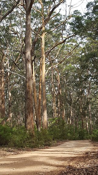
Eucalyptus diversicolor, commonly known as karri, is a species of flowering plant in the family Myrtaceae and is endemic to the south-west of Western Australia. It is a tall tree with smooth light grey to cream-coloured, often mottled bark, lance-shaped adult leaves and barrel-shaped fruit. Found in higher rainfall areas, karri is commercially important for its timber.

<span class="mw-page-title-main">Southwest Australia</span> Biogeographic region of Western Australia

Southwest Australia is a biogeographic region in Western Australia. It includes the Mediterranean-climate area of southwestern Australia, which is home to a diverse and distinctive flora and fauna.

<span class="mw-page-title-main">Donnelly River, Western Australia</span> Town in Western Australia

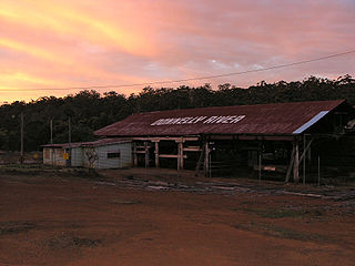
Donnelly River Village is a former timber mill town and present-day holiday village in the Shire of Nannup, in the South West region of Western Australia. The Village is located at a point between Nannup, Bridgetown and Manjimup on the Donnelly River, a small, seasonal river at this point, which flows into the Southern Ocean at 34°29′02.4″S115°40′27.8″E. The name also applies to a winery downstream on the Vasse Highway and the township's cottages are sometimes confused with cottages built on the lower reaches of the Donnelly River at 34°28′56″S115°41′00″E.

Millbridge is a northeastern suburb of Bunbury, Western Australia, adjoining Eaton 9 km from the centre of Bunbury. At the 2021 census, it had a population of 2,736. Its local government area is the Shire of Dardanup.

<span class="mw-page-title-main">Red-eared firetail</span> Species of bird

The red-eared firetail, also known as the boorin, is a small finch-like species of bird. It occurs in dense wetland vegetation of coastal to sub-coastal regions in Southwest Australia. Its appearance is considered appealing, with white spots, black barring and vivid crimson marks at the ear and upper tail. Red-eared firetails are usually only glimpsed briefly, if at all, as they move rapidly and discreetly through their habitat. Most observations occur when their soft voice is heard, or in flight when flushed from the dense scrub. Males and females are similar in colouring and bond as lifelong pairs that occupy a territory centred on their roosting and brooding nest site. The species occupy a similar ecological niche to the beautiful firetail Stagonopleura bella found in the east of Australia, although unlike other species of the genus they only occasionally group together and are almost never seen in large flocks.

<span class="mw-page-title-main">Kalgan River</span> River in Western Australia

The Kalgan River is a river in the Great Southern region of Western Australia.

Galaxiella munda is a species of fish in the family Galaxiidae. It is endemic to inland waters of southwestern Australia, and known as the Western mud minnow. In 1999 the Mud Minnow was not included in the list of threatened species under the Environment Protection and Biodiversity Conservation Act, but is listed as Endangered on the IUCN Red List.

The Goodga River is a river in the Great Southern region of Western Australia.

Toolibin Lake is a seasonal fresh to brackish water perched lake or wooded swamp, in south-western Australia. The lake is contained with a 493-hectare (1,218-acre) nature reserve and it is located about 200 kilometres (124 mi) south-east of Perth, in the Shire of Narrogin, and 40 kilometres (25 mi) east of the town of Narrogin, in the Wheatbelt region of Western Australia. The lake is listed by the Australian Government as a threatened ecological community under the Environment Protection and Biodiversity Conservation Act 1999.

<span class="mw-page-title-main">Perth Wetlands</span> Bodies of water on Swan Coastal Plain

The Perth Wetlands, also known as the Perth Great Lakes or the Great Lakes District, was a collection of fresh-water wetlands, swamps and lakes located on the Swan Coastal Plain north of the city of Perth in Western Australia. Over a period of 80 years from the first British settlement in Western Australia in 1829 most of the wetlands were reclaimed for use as housing, parks and market gardens.

<i>Xanthorrhoea gracilis</i> Species of flowering plant

Xanthorrhoea gracilis, commonly known as the graceful grasstree, grassboy or mimidi, is a species of grasstree of the genus Xanthorrhoea native to Western Australia.

<span class="mw-page-title-main">Lake Towerrinning</span> Lake in Western Australia

Lake Towerrinning or Towerrinning Lake is a permanent brackish lake in the Wheatbelt region of Western Australia located approximately 32 km (20 mi) south of Darkan, 44 km (27 mi) south west of Wagin and about 245 km (152 mi) south east of Perth. The lake is managed by the Department of Parks and Wildlife since it is used as a recreational facility; the Shire of West Arthur leases part of it as a gazetted water ski area.

<span class="mw-page-title-main">Lake Nunijup</span> Salt lake in Western Australia

Lake Nunijup is an ephemeral salt lake located in the Great Southern region of Western Australia, approximately 27 km (17 mi) south west of Cranbrook and 41 km (25 mi) north west of Mount Barker.

<span class="mw-page-title-main">Wellington National Park</span> Protected area in Western Australia

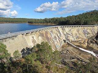
Wellington National Park is a national park in Western Australia, located 10 kilometres (6 mi) west of Collie and approximately 215 km (134 mi) south of Perth in the Shire of Collie along the Coalfields Highway.

<span class="mw-page-title-main">The Spectacles Wetlands</span> Wetlands in Perth, Western Australia

The Spectacles Wetlands is a wetland located in the eponymous suburb, 30 kilometres (19 mi) south of the central business district of Perth, the capital of Western Australia. It is part of Beeliar Regional Park.

<span class="mw-page-title-main">Eastern Suburbs Banksia Scrub</span> Indigenous woodland community in Sydney, Australia

The Eastern Suburbs Banksia Scrub, which also incorporates Sydney Coastal Heaths, is a remnant sclerophyll scrubland and heathland that is found in the eastern and southern regions of Sydney, New South Wales, Australia. Listed under the Environment Protection and Biodiversity Conservation Act 1999 as and endangered vegetation community and as 'critically endangered' under the NSW Biodiversity Conservation Act 2016, the Eastern Suburbs Banksia Scrub is found on ancient, nutrient poor sands either on dunes or on promontories. Sydney coastal heaths are a scrubby heathland found on exposed coastal sandstone plateau in the south.

References

  1. 1 2 3 4 Munro, Jennifer (2006). Donnelly River Action Plan (pd). Manjimup, W.A.: Manjimup Land Conservation District Committee. ISBN   0-9802852-0-8 . Retrieved 31 January 2016.
  2. "Context Report on Southwest Water Resources" (PDF). 2008. Archived from the original (PDF) on 6 September 2008. Retrieved 10 November 2008.
  3. Moore, George Fletcher (1834). Doyle, Martin (ed.). Extracts from the letters and journals of George Fletcher Moore: Esq. now filling a judicial office at the Swan River Settlement. London: Orr and Smith. p. 235. Retrieved 31 January 2016.
  4. Statham-Drew, Pamela (2003). James Stirling: admiral and founding governor of Western Australia. Crawley, WA: University of Western Australia Press. p. 47. ISBN   1876268948.
  5. "History of river names – D". Western Australian Land Information Authority. Retrieved 3 September 2011.
  6. "Fish Fauna of the Donnelly River, Western Australia" (PDF). 2006. Retrieved 10 November 2008.

34°29′S115°40′E / 34.483°S 115.667°E / -34.483; 115.667