Related Research Articles
Drygalski Island is an ice-capped island that is 20.4 kilometres (11 nmi) long and rises to 325 m (1,066 ft) in the Davis Sea of the Southern Ocean, about 85 km (53 mi) north of the coast of Queen Mary Land and 45 km (28 mi) north-northeast of Cape Filchner. The island has an area of 220 km2 (85 sq mi).

Sir Vivian Ernest Fuchs was an English scientist-explorer and expedition organizer. He led the Commonwealth Trans-Antarctic Expedition which reached the South Pole overland in 1958.

Marie Byrd Land (MBL) is an unclaimed region of Antarctica. With an area of 1,610,000 km2 (620,000 sq mi), it is the largest unclaimed territory on Earth. It was named after the wife of American naval officer Richard E. Byrd, who explored the region in the early 20th century.

Graham Land is the portion of the Antarctic Peninsula that lies north of a line joining Cape Jeremy and Cape Agassiz. This description of Graham Land is consistent with the 1964 agreement between the British Antarctic Place-names Committee and the US Advisory Committee on Antarctic Names, in which the name "Antarctic Peninsula" was approved for the major peninsula of Antarctica, and the names Graham Land and Palmer Land for the northern and southern portions, respectively. The line dividing them is roughly 69 degrees south.

Aviator Glacier is a major valley glacier in Antarctica that is over 60 miles (97 km) long and 5 miles (8.0 km) wide, descending generally southward from the plateau of Victoria Land along the west side of Mountaineer Range, and entering Lady Newnes Bay between Cape Sibbald and Hayes Head where it forms the Aviator Glacier Tongue.
Oates Land is a region of Antarctica. It is variously defined as a portion of the East Antarctica near the coast stretching along and inland from the Oates Coast and as an officially delineated wedge-shaped segment of the Australian Antarctic Territory. The segment of the Australian claim extends between 153°45' E and 160° E, forming a wedge between Latitude 60° S and the South Pole. It is bounded in the east by the Ross Dependency and overlaps George V Land to the west.

Multiple governments have set up permanent research stations in Antarctica and these bases are widely distributed. Unlike the drifting ice stations set up in the Arctic, the research stations of the Antarctic are constructed either on rock or on ice that is fixed in place.

The Mirny Station is a Russian first Antarctic science station located in Queen Mary Land, Antarctica, on the Antarctic coast of the Davis Sea.

The Pole of Inaccessibility research station is a defunct Soviet research station in Kemp Land, Antarctica, at the southern pole of inaccessibility as defined in 1958 when the station was established. Later definitions give other locations, all relatively near this point. It performed meteorological observations from 14 to 26 December 1958. The Pole of Inaccessibility has the world's coldest year-round average temperature of −58.2 °C (−72.8 °F).

Snow Hill Island is an almost completely snowcapped island, 33 km (21 mi) long and 12 km (7.5 mi) wide, lying off the east coast of the Antarctic Peninsula. It is separated from James Ross Island to the north-east by Admiralty Sound and from Seymour Island to the north by Picnic Passage. It is one of several islands around the peninsula known as Graham Land, which is closer to Argentina and South America than any other part of the Antarctic continent.

Zykov Glacier is a valley glacier in northern Victoria Land, Antarctica, east of Saddle Peak and Mount Kostka in the Anare Mountains. It is about 25 miles (40 km) long, and flows northwest, reaching the Pennell Coast between Cape Williams and Cooper Bluffs. Photographed by the Soviet Antarctic Expedition from the survey ship Ob in 1958, it was named by them for student navigator Ye. Zykov, who died in Antarctica, February 3, 1957.
The Humboldt Mountains are a group of mountains immediately west of the Petermann Ranges, forming the westernmost portion of the Wohlthat Mountains in Queen Maud Land, Antarctica.
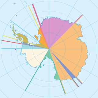
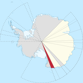
Seven sovereign states – Argentina, Australia, Chile, France, New Zealand, Norway, and the United Kingdom – have made eight territorial claims in Antarctica. These countries have tended to place their Antarctic scientific observation and study facilities within their respective claimed territories; however, a number of such facilities are located outside of the area claimed by their respective countries of operation, and countries without claims such as China, India, Italy, Japan, Pakistan, Russia, South Africa (SANAE), Ukraine, and the United States have constructed research facilities within the areas claimed by other countries. There are overlaps among the territories claimed by Argentina, Chile, and the United Kingdom.

Queen Maud Land is a roughly 2.7-million-square-kilometre (1.0-million-square-mile) region of Antarctica claimed by Norway as a dependent territory. It borders the claimed British Antarctic Territory 20° west and the Australian Antarctic Territory 45° east. In addition, a small unclaimed area from 1939 was annexed in June 2015. Positioned in East Antarctica, it makes out about one-fifth of the continent, and is named after the Norwegian queen Maud of Wales (1869–1938).

Flask Glacier, is a gently-sloping glacier, 25 nautical miles long, flowing east from Bruce Plateau to enter Scar Inlet between Daggoo Peak and Spouter Peak in Graham Land, Antarctica. The lower reaches of this glacier were surveyed and photographed by the Falklands Islands Dependencies Survey (FIDS) in 1947. The entire glacier was photographed by the Falkland Islands and Dependencies Aerial Survey Expedition in 1955–56, and mapped by the FIDS in 1957. It was named by the UK Antarctic Place-names Committee after the third mate on the Pequod in Herman Melville's Moby-Dick; or, The White Whale.
Kartografov Island is a small coastal island lying in the western part of the mouth of Harald Bay, Oates Land, Antarctica. It was photographed by U.S. Navy Operation Highjump (1946–47), the Soviet Antarctic Expedition (1957–58) and the Australian National Antarctic Research Expedition (1959). The island was named "Ostrov Kartografov" by the Soviet expedition.
Andrey Petrovich Kapitsa was a Soviet and Russian geographer and Antarctic explorer, discoverer of Lake Vostok, the largest subglacial lake in Antarctica. He was a member of the Kapitsa family, a scientific dynasty in Russia.

International competition extended to the continent of Antarctica during the World War II era, though the region saw no combat. During the prelude to war, Nazi Germany organised the 1938 Third German Antarctic Expedition to preempt Norway's claim to Queen Maud Land. The expedition served as the basis for a new German claim, called New Swabia. A year later, the United States Antarctic Service Expedition established two bases, which operated for two years before being abandoned. Responding to these encroachments, and taking advantage of Europe's wartime turmoil, the nearby nations of Chile and Argentina made their own claims. In 1940 Chile proclaimed the Chilean Antarctic Territory in areas already claimed by Britain, while Argentina proclaimed Argentine Antarctica in 1943 in an overlapping area.
References
- Nepomnyashchi, A. (September 1968) "Russians in the Antarctic" in Arctic. 21(3):204–05
| | This Antarctica-related article is a stub. You can help Wikipedia by expanding it. |