
Cheddar is a large village and civil parish in the English county of Somerset. It is situated on the southern edge of the Mendip Hills, 9 miles (14 km) north-west of Wells, 11 miles (18 km) south-east of Weston-super-Mare and 18 miles (29 km) south-west of Bristol. The civil parish includes the hamlets of Nyland and Bradley Cross. The parish had a population of 5,755 in 2011 and an acreage of 8,592 acres (3,477 ha) as of 1961.

Cheddar Gorge is a limestone gorge in the Mendip Hills, near the village of Cheddar, Somerset, England. The gorge is the site of the Cheddar show caves, where Britain's oldest complete human skeleton, Cheddar Man, estimated to be 9,000 years old, was found in 1903. Older remains from the Upper Late Palaeolithic era have been found. The caves, produced by the activity of an underground river, contain stalactites and stalagmites. The gorge is part of a Site of Special Scientific Interest called Cheddar Complex.

The Mendip Hills is a range of limestone hills to the south of Bristol and Bath in Somerset, England. Running from Weston-super-Mare and the Bristol Channel in the west to the Frome valley in the east, the hills overlook the Somerset Levels to the south and the Chew Valley and other tributaries of the Avon to the north. The highest point, at 325 metres (1,066 ft) above sea level, is Beacon Batch which is the summit area atop Black Down. The hills gave their name to the former local government district of Mendip, which administered most of the local area until April 2023. The higher, western part of the hills, covering 198 km2 (76 sq mi) has been designated an Area of Outstanding Natural Beauty (AONB), which gives it a level of protection comparable to a national park.
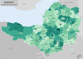
Somerset is a historic county in the south west of England. There is evidence of human occupation since prehistoric times with hand axes and flint points from the Palaeolithic and Mesolithic eras, and a range of burial mounds, hill forts and other artefacts dating from the Neolithic, Bronze and Iron Ages. The oldest dated human road work in Great Britain is the Sweet Track, constructed across the Somerset Levels with wooden planks in the 39th century BCE.
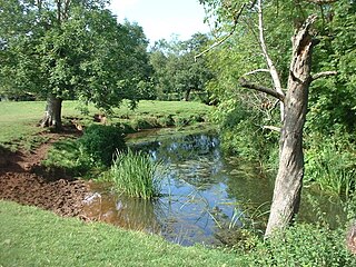
The River Chew is a small river in England that flows for some 17 miles (27 km) through the North Somerset countryside to form the Chew Valley before merging with the River Avon.

Chew Valley Lake is a reservoir in Chew Stoke, Chew Valley, Somerset, England. It is the fifth-largest artificial lake in the United Kingdom, with an area of 1,200 acres (4.9 km2). The lake, created in the early 1950s, was opened by Queen Elizabeth II in 1956. It provides much of the drinking water for the city of Bristol and surrounding area, taking its supply from the Mendip Hills. Some of the lake water is used to maintain the flow in the River Chew.
Chew Stoke is a small village and civil parish in the affluent Chew Valley, in Somerset, England, about 8 miles (13 km) south of Bristol and 10 miles north of Wells. It is at the northern edge of the Mendip Hills, a region designated by the United Kingdom as an Area of Outstanding Natural Beauty, and is within the Bristol and Bath green belt. The parish includes the hamlet of Breach Hill, which is approximately 2 miles (3.2 km) southwest of Chew Stoke itself.

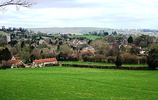
Pensford is the largest village in the civil parish of Publow in Somerset, England. It lies in the Chew Valley, approximately 7 miles (11 km) south of Bristol, 8 miles (13 km) west of Bath, and 14 miles (23 km) north of Wells. It is on the A37 road from Bristol to Shepton Mallet.
Philip Arthur Rahtz was a British archaeologist.
The Chew Valley is an affluent area in North Somerset, England, named after the River Chew, which rises at Chewton Mendip, and joins the River Avon at Keynsham. Technically, the area of the valley is bounded by the water catchment area of the Chew and its tributaries; however, the name Chew Valley is often used less formally to cover other nearby areas, for example, Blagdon Lake and its environs, which by a stricter definition are part of the Yeo Valley. The valley is an area of rich arable and dairy farmland, interspersed with a number of villages.

Publow is a small village and civil parish in Bath and North East Somerset, England. It lies beside the River Chew in the Chew Valley. It is 7 miles from Bristol, 9 miles from Bath, and 4 miles from Keynsham. The principal settlement in the parish is Pensford. The parish also includes the village of Belluton and part of the village of Woollard. At the 2011 census it had a population of 1,119.

Woollard is a small village on the River Chew in the affluent Chew Valley in England. It is in the Bath and North East Somerset council area and the ceremonial county of Somerset. The village is 7 miles (11 km) from Bristol, 9 miles (14 km) from Bath, and 4 miles (6.4 km) from Keynsham.

Gough's Cave is located in Cheddar Gorge on the Mendip Hills, in Cheddar, Somerset, England. The cave is 115 m (377 ft) deep and is 3.405 km (2.12 mi) long, and contains a variety of large chambers and rock formations. It contains the Cheddar Yeo, the largest underground river system in Britain.

St Thomas à Becket Church in Pensford, Somerset southwest England, dates from the 14th century, active in 1341, although only the tower remains from that date, the rest of the church having been rebuilt in 1868 by Giles and Robinson Architects and the church was reconsecrated in 1869.
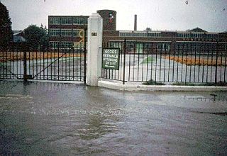
The Great Flood of 1968 was a flood caused by a pronounced trough of low pressure which brought exceptionally heavy rain and thunderstorms to South East England and France in mid-September 1968, with the worst on Sunday 15 September 1968, and followed earlier floods in South West England during July. This was likely the severest inland flood experienced in the Home Counties during the last 100 years.

The county of Somerset is in South West England, bordered by the Bristol Channel and the counties of Bristol and Gloucestershire to the north, and Wiltshire to the east, Dorset to the south, and Devon to the west. The climate, influenced by its proximity to the Atlantic Ocean and the prevailing westerly winds, tends to be mild, damp and windy.

The Cheddar Yeo is a small river in Somerset, England. Beneath the limestone of the Mendip Hills it forms the largest underground river system in Britain. After emerging into Cheddar Gorge it flows through the village of Cheddar, where it has been used in the past to power mills. From the Middle Ages until the 19th century the river had ports for seagoing vessels but is no longer navigable. Some of the water, which is of good quality, is diverted into Cheddar Reservoir to provide drinking water for Bristol.

The Spanish Plume is a weather pattern in which a plume of warm air moves from the Iberian plateau or the Sahara to northwestern Europe, causing thunderstorms. This meteorological pattern can lead to extreme high temperatures and intense rainfall during the summer months, with potential for flash flooding, damaging hail, and tornado formation. Some of these intense thunderstorms are formed from thermal lows, which are also known as heat lows. Thermal lows can be semipermanent features around some parts of Europe, particularly in the summer season. These thermal lows can be developed or created around Spain, Portugal, France, etc., during the summer season because of the intense heat. Thermal low pressure can be located around the world, particularly in the summer or in tropical regions.

Pensford Viaduct is a disused railway bridge in the village of Pensford, within the historic English county of Somerset, now unitary authority Bath and North East Somerset. It is a Grade II listed building.

The July 1968 United Kingdom thunderstorms were the most severe dust fall thunderstorms in the British Isles for over 200 years. A layer of mineral dust blowing north from the Sahara met cold, wet air over the British Isles, resulting in thick, dense clouds and severe thunderstorms across most of England and Wales. These clouds completely blotted out the light in some areas and the rain and hail resulted in property damage and flooding, and at least four people were killed. During the storm, Leeming Bar in North Yorkshire saw 35.7 millimetres (1.41 in) of rain in under 10 minutes – a UK record until 2003.
