
Southern California is a geographic and cultural region that generally comprises the southern portion of the U.S. state of California. It includes the Los Angeles metropolitan area as well as the Inland Empire. The region generally contains ten of California's 58 counties: Los Angeles, San Diego, Orange, Riverside, San Bernardino, Kern, Ventura, Santa Barbara, San Luis Obispo, and Imperial counties.
Goleta is a city in southern Santa Barbara County, California, United States. It was incorporated as a city in 2002, after a long period as the largest unincorporated populated area in the county. As of the 2000 census, the census-designated place (CDP) had a total population of 55,204. A significant portion of the census territory of 2000 did not include the newer portions of the city. The population of Goleta was 32,690 at the 2020 census. It is known for being close to the University of California, Santa Barbara (UCSB), campus.

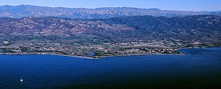
Santa Barbara is a coastal city in Santa Barbara County, California, of which it is also the county seat. Situated on a south-facing section of coastline, the longest such section on the West Coast of the United States excepting Alaska, the city lies between the steeply rising Santa Ynez Mountains and the Pacific Ocean. Santa Barbara's climate is often described as Mediterranean, and the city has been dubbed "The American Riviera". According to the 2020 U.S. Census, the city's population was 88,665.

The 1994 Northridge earthquake affected the Los Angeles area of California on January 17, 1994, at 04:30:55 PST. The epicenter of the moment magnitude 6.7 blind thrust earthquake was beneath the San Fernando Valley. Lasting approximately 8 seconds and achieving the largest peak ground acceleration of over 1.7 g, it was the largest earthquake in the area since 1971. Shaking was felt as far away as San Diego, Turlock, Las Vegas, Richfield, Phoenix, and Ensenada. Fifty-seven people died and more than 9,000 were injured. In addition, property damage was estimated to be $13–50 billion, making it among the costliest natural disasters in U.S. history.
The 1857 Fort Tejon earthquake occurred at about 8:20 a.m. on January 9 in central and Southern California. One of the largest recorded earthquakes in the United States, with an estimated moment magnitude of 7.9, it ruptured the southern part of the San Andreas Fault for a length of about 225 miles, between Parkfield and Wrightwood.
The 1999 Hector Mine earthquake occurred in Southern California, United States, on October 16 at 02:46:50 PDT. Its moment magnitude was 7.1 and the earthquake was preceded by 12 foreshocks, the largest of which had a magnitude of 3.8. The event is thought to have been triggered by the 1992 Landers earthquake which occurred seven years earlier. It also deformed nearby faults vertically and horizontally. The earthquake's hypocenter was at a depth of 20 kilometers and its epicenter at 34.603° N 116.265° W.
The 1994 Bolivia earthquake occurred on June 9, 1994. The epicenter was located in a sparsely populated region in the Amazon jungle, about 200 miles from La Paz.
The Richter scale, also called the Richter magnitude scale, Richter's magnitude scale, and the Gutenberg–Richter scale, is a measure of the strength of earthquakes, developed by Charles Richter in collaboration with Beno Gutenberg, and presented in Richter's landmark 1935 paper, where he called it the "magnitude scale". This was later revised and renamed the local magnitude scale, denoted as ML or ML .
The 1925 Santa Barbara earthquake hit the area of Santa Barbara, California on June 29, with a moment magnitude between 6.5 and 6.8 and a maximum Mercalli Intensity of IX (Violent). It resulted in 13 deaths and destroyed the historic center of the city, with damage estimated at $8 million.

The 1812 Ventura earthquake occurred on the morning of December 21 at 11:00 Pacific Standard Time (PST). The 7.2 earthquake was assigned a with a maximum Modified Mercalli intensity of X (Extreme). The seismic shaking was followed by a tsunami that considerably damaged places in present-day Santa Barbara and Ventura County, California, which was at the time a territory of the Spanish Empire. One person was killed during the earthquake while another from an aftershock. The earthquake occurred while the region was recovering from another event on December 8.
The 1927 Lompoc earthquake occurred on November 4 at 05:49 PST with an epicenter off the coast of Santa Barbara County Southern California. The earthquake measured 7.0 on the moment magnitude scale and had a maximum Modified Mercalli intensity of IX (Violent). It caused widespread damage in several towns of Santa Barbara County. A 2 m tsunami damaged railroad infrastructure and was recorded in Hawaii. There were no injuries or deaths from the earthquake.
The 1968 Borrego Mountain earthquake occurred on April 8, at 18:28 PST in the geologically active Salton Trough of Southern California. The Salton Trough represents a pull-apart basin formed by movements along major faults. This region is dominated by major strike-slip faults one of them being the San Jacinto Fault which produced the 1968 earthquake. The mainshock's epicenter was near the unincorporated community of Ocotillo Wells in San Diego County. The moment magnitude (Mw ) 6.6 strike-slip earthquake struck with a focal depth of 11.1 km (6.9 mi). The zone of surface rupture was assigned a maximum Modified Mercalli intensity (MMI) of VII.
The 1906 Manasi earthquake (玛纳斯地震), also known as the Manas earthquake occurred in the morning of December 23, 1906, at 02:21 UTC+8:00 local time or December 22, 18:21 UTC. It measured 8.0–8.3 on the moment magnitude scale and 8.3 on the surface-wave magnitude scale. The epicenter of this earthquake is located in Manas County, Xinjiang, China. An estimated 280–300 people died and another 1,000 more were injured by the earthquake.
The Nemuro-Oki earthquake in scientific literature, occurred on June 17 at 12:55 local time. It struck with an epicenter just off the Nemuro Peninsula in northern Hokkaidō, Japan. It measured 7.8–7.9 on the moment magnitude scale (Mw ), 8.1 on the tsunami magnitude scale (Mt ) and 7.4 on the Japan Meteorological Agency magnitude scale (MJMA ).
The 2020 Kashgar earthquake, also known as the Jiashi earthquake occurred on 19 January 2020 at 21:27:56 China Standard Time in Xinjiang Province, China. According to the United States Geological Survey, the earthquake had a moment magnitude of 6.0 and a surface wave magnitude of 6.4 according to the China Earthquake Network Center. It struck at a shallow depth of 5.6 km according to the USGS while the CENC has the figure at 16 km. Local emergency management agencies said the earthquake damaged more than 1,000 homes and businesses in the nearby populated towns and villages. One person is known to have died while two other children were injured.

An earthquake occurred off the coast of the Alaska Peninsula on July 28, 2021, at 10:15 p.m. local time. The large megathrust earthquake had a moment magnitude of 8.2 according to the United States Geological Survey (USGS). A tsunami warning was issued by the National Oceanic and Atmospheric Administration (NOAA) but later cancelled. The mainshock was followed by a number of aftershocks, including three that were of magnitude 5.9, 6.1 and 6.9 respectively.

The 2014 La Habra earthquake was a magnitude 5.1 earthquake that occurred on March 28, 2014, at 9:09:42 p.m. PDT. Although given the name "La Habra" it was centered in Brea, a city in northern Orange County. Despite its moderate magnitude, it had a maximum Mercalli intensity of VII, and caused a total of $10.8 million in damage. Thirteen water mains broke in Fullerton, forcing roughly 70 families to be displaced from their homes after they were declared temporarily uninhabitable.
The 1950 Calama earthquake occurred near the Argentina–Chile border with an epicenter near Calama, Chile in the Atacama Desert on December 9. The event had a hypocenter depth of 113.9 km, beneath the Caichinque volcanic complex. It measured magnitude Mw 8.2 on the moment magnitude scale, making it the largest intermediate depth earthquake ever recorded on Chilean soil. One person was killed and an unspecified number of people were injured in Calama.
The 1983 Kaoiki earthquake struck southern Hawaii Island on the morning of November 16, 1983. Measuring Mw 6.7, it was the largest to hit the island since 1975. The epicenter was located 50 km (30 mi) southeast of Hilo with an approximated depth of 12 km (7 mi). The shallow strike-slip earthquake was assigned a maximum intensity of IX (Violent) on the Modified Mercalli scale. 6 people were injured, widespread damage and landslides were reported across the island.
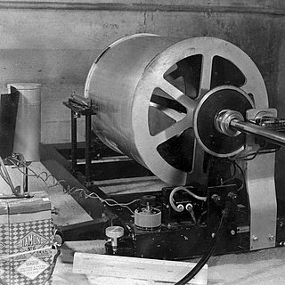
The Wood–Anderson seismometer is a torsion seismometer developed in the United States by Harry O. Wood and John August Anderson in the 1920s to record local earthquakes in southern California. It photographically records the horizontal motion. The seismometer uses a pendulum of 0.8g, its period is 0.8 seconds, its magnification is 2,800 times, and its damping constant is 0.8. Charles Francis Richter developed the Richter magnitude scale using the Wood–Anderson seismometer.

