2023 Sunbury earthquake

Last updated

2023 Sunbury earthquake
Australia Victoria metropolitan Melbourne location map.svg
Bullseye1.png
Australia Victoria relief location map.jpg
Bullseye1.png
Australia relief map.jpg
Bullseye1.png
UTC  time2023-05-28 13:41:51
ISC  event 626225065
USGS-ANSS ComCat
Local date28 May 2023 (2023-05-28)
Local time23:41:51
Duration5–10 seconds
Magnitude ML 4.0 (Geoscience Australia) [1]
mb 3.8 (USGS) [2]
Depth2.0 km (1.2 mi) (Geoscience Australia) [1]
9.0 km (5.6 mi) (USGS) [2]
Epicenter 37°34′S144°51′E / 37.56°S 144.85°E / -37.56; 144.85
FaultUnknown
Max. intensity VI (Strong) [3]
Peak acceleration0.1 g [4]
AftershocksML2.6 [5]
CasualtiesNone

An earthquake struck approximately 28 kilometres NNW of Melbourne CBD, near the suburb of Sunbury in Victoria, Australia on 28 May 2023, at 23:41 local time (AEST). The earthquake measured 4.0 on the moment magnitude scale. [1] It caused minor structural damage in parts of Melbourne and was felt as far as Tasmania and the Victoria-New South Wales border. Although the earthquake was weaker than the magnitude 5.9 Mansfield earthquake in 2021, this earthquake occurred within metropolitan Melbourne, so it was felt at a similar strength there, albeit for a lesser amount of time. [6]

Contents

Tectonic setting

The Australian landmass is situated in the Australian Plate, far from any known active plate boundary, where most of the world's earthquakes occur. Such earthquakes at the plate boundary are known as interplate earthquakes. In Australia, earthquakes occurring within the Australian Plate are known as intraplate earthquakes because they happen within a tectonic plate rather than at the boundary. [7]

The earthquake is situated in the Lachlan Fold Belt, an orogenic belt consisting of folded and faulted strata. This zone formed as a result of plate convergence occurring at the eastern boundary of the supercontinent Gondwana during the Neoproterozoic. [8] From the Neoproterozoic to Early Devonian, the region was dominated by thrusting and some rifting. Crustal deformation were later accommodated by predominantly strike-slip faulting in the Devonian. One of the major strike-slip faults accommodating this deformation is the Baragwanath Transform; a transform fault. Rifting also occurred in this period, leading to volcanism. By the Middle Devonian, the Baragwanath Transform became extinct. [9]

This earthquake occurred near the Clarkefield Fault Scarp – a neotectonic feature with a history of earthquakes between 5.3 and 2.6 million years ago. However, it is unknown whether the earthquake began in a mapped or an unmapped fault. There are many of these historic faults in Victoria, due to its seismically active history. [10]

Earthquake

According to Geoscience Australia, the earthquake occurred at a very shallow depth of 2 km, while the U.S. Geological Survey placed the depth at 9.0 km. [1] [2] The geological fault involved has not been identified. The earthquake was preliminarily determined to have a magnitude of 3.8, but was later upgraded to a magnitude of 4.0 after a manual review two days later. [11]

On the modified Mercalli intensity scale, the earthquake earned a maximum intensity of VI (Strong) by Geoscience Australia, while USGS put it at V (Moderate). [2] Tremors were felt throughout Victoria and as far as Hobart, Tasmania and Albury, New South Wales. [12]

Impact

The quake generated 5 to 10 seconds of shaking which was widely felt in Melbourne. [6] More than 26,000 felt reports were submitted to Geoscience Australia. [13] Slight damages including buckled roads, cracked buildings, cracked plaster and fallen pictures were reported across the northern and western suburbs of Melbourne near the epicentre region. [14] [15] It was the strongest earthquake within 40 km (25 mi) of Melbourne in more than 120 years, with the last stronger earthquake being a magnitude 4.5 quake in 1902. [16]

Response

An earthquake advice was issued by VicEmergency which covered the entirety of Greater Melbourne and parts of Victoria. [17] The earthquake made headlines in Australian news outlets the moment it occurred, due to the rarity of an earthquake within Melbourne and the unusual intensity of a low magnitude earthquake. [18]

Further tremors

On 30 May 2023, a 2.6 magnitude aftershock which happened 2 minutes after the initial quake was identified by Geoscience Australia after manual analysis. [19] Another 2.3-magnitude tremor occurred in the Melbourne Suburb of Croydon, about 33 km east of Melbourne's CBD at 17:03 two days later. [20] It was felt by approximately 400 people. [21]

See also

Related Research Articles

<span class="mw-page-title-main">Earthquake</span> Sudden movement of the Earths crust

An earthquake – also called a quake, tremor, or temblor – is the shaking of the Earth's surface resulting from a sudden release of energy in the lithosphere that creates seismic waves. Earthquakes can range in intensity, from those so weak they cannot be felt, to those violent enough to propel objects and people into the air, damage critical infrastructure, and wreak destruction across entire cities. The seismic activity of an area is the frequency, type, and size of earthquakes experienced over a particular time. The seismicity at a particular location in the Earth is the average rate of seismic energy release per unit volume. The word tremor is also used for non-earthquake seismic rumbling.

<span class="mw-page-title-main">Earthquake swarm</span> Series of localized seismic events within a short time period

In seismology, an earthquake swarm is a sequence of seismic events occurring in a local area within a relatively short period. The time span used to define a swarm varies, but may be days, months, or years. Such an energy release is different from the situation when a major earthquake is followed by a series of aftershocks: in earthquake swarms, no single earthquake in the sequence is obviously the main shock. In particular, a cluster of aftershocks occurring after a mainshock is not a swarm.

<span class="mw-page-title-main">September 2007 Sumatra earthquakes</span> Earthquakes affecting Indonesia

The September 2007 Sumatra earthquakes were a series of megathrust earthquakes that struck the Sunda Trench off the coast of Sumatra, Indonesia, with three of magnitude 7 or greater. A series of tsunami bulletins was issued for the area. The most powerful of the series had a magnitude of 8.5, which makes it in the top 20 of the largest earthquakes ever recorded on a seismograph.

<span class="mw-page-title-main">2007 Gisborne earthquake</span> Earthquake in New Zealand

The 2007 Gisborne earthquake occurred under the Pacific Ocean about 50 kilometres (31 mi) off the eastern coast of New Zealand's North Island at 8:55 pm NZDT on 20 December. The tremor had a moment magnitude of 6.7 and maximum Mercalli intensity of VII, and affected the city of Gisborne, but was felt widely across the country from Auckland in the north to Dunedin in the south.

The 1975 Morris earthquake occurred in western Minnesota on July 9 at 14:54:15 UTC, or 9:54 a.m. local time. The strongest instrumentally recorded rupture in the history of the state, it registered at magnitude 4.6 Mn and had a maximum Mercalli intensity of VI (Strong). It was the first earthquake to be recorded on any seismic instrument in the state since 1917. Tremors were felt over much of Minnesota, northern Iowa, and the eastern Dakotas.

<span class="mw-page-title-main">1968 Illinois earthquake</span> Largest recorded earthquake in Illinois, US

The 1968 Illinois earthquake was the largest recorded earthquake in the U.S. Midwestern state of Illinois. Striking at 11:02 am on November 9, it measured 5.4 on the Richter scale. Although no fatalities occurred, the event caused considerable structural damage to buildings, including the toppling of chimneys and shaking in Chicago, the region's largest city. The earthquake was one of the most widely felt in U.S. history, largely affecting 23 states over an area of 580,000 sq mi (1,500,000 km2). In studying its cause, scientists discovered the Cottage Grove Fault in the Southern Illinois Basin.

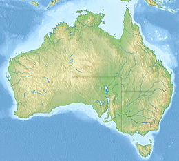
Earthquakes have occurred in Western Australia (WA) on a regular basis throughout its geological history.
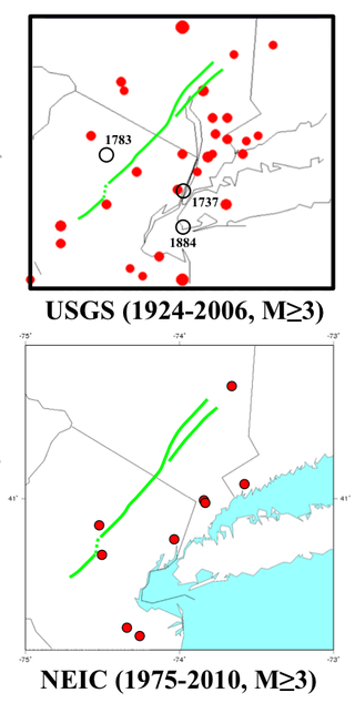
<span class="mw-page-title-main">2011 Lorca earthquake</span> Moderate 5.1 Mw earthquake in Spain

The 2011 Lorca earthquake was a moderate 5.1 Mw earthquake that occurred 6:47 p.m. CEST on 11 May 2011, near the town of Lorca, causing significant localized damage in the Region of Murcia, Spain, and panic among locals, and displacing many from their homes. The quake was preceded by a magnitude 4.4 foreshock at 17:05, that inflicted substantial damage to many older structures in the area, including the historical Espolón Tower of Lorca Castle, the Hermitage of San Clemente and the Convent of Virgen de Las Huertas. Three people were killed by a falling cornice. A total of nine deaths have been confirmed, while dozens are reported injured. The earthquake was the worst to hit the region since a 5.0 Mw tremor struck west of Albolote, Granada in 1956.

<span class="mw-page-title-main">June 2011 Christchurch earthquake</span> June 2011 earthquake in New Zealand

The June 2011 Christchurch earthquake was a shallow magnitude 6.0 Mw earthquake that occurred on 13 June 2011 at 14:20 NZST. It was centred at a depth of 7 km (4.3 mi), about 5 km (3 mi) south-east of Christchurch, which had previously been devastated by a magnitude 6.2 MW earthquake in February 2011. The June quake was preceded by a magnitude 5.9 ML tremor that struck the region at a slightly deeper 8.9 km (5.5 mi). The United States Geological Survey reported a magnitude of 6.0 Mw and a depth of 9 km (5.6 mi).

The 1954 Adelaide earthquake had its epicentre at Darlington, a suburb of the city of Adelaide in South Australia, some 12 km (7.5 mi) to the south of the Adelaide city centre. The quake took place at 3:40 am in the early morning of 1 March 1954 and had a reported magnitude of 5.6. An area of more than 700 km2 sustained an intensity greater than V on the Mercalli intensity scale.

The 1906 Swansea earthquake hit near the town of Swansea, Glamorgan, Wales on 27 June. It was one of the most damaging to hit Britain during the twentieth century, with a small area reaching an intensity of VII on the Medvedev–Sponheuer–Karnik scale.

<span class="mw-page-title-main">2011 Oklahoma earthquake</span> 2011 earthquake near Prague, Oklahoma

The 2011 Oklahoma earthquake was a 5.7 magnitude intraplate earthquake which occurred near Prague, Oklahoma on November 5 at 10:53 p.m. CDT in the U.S. state of Oklahoma. The epicenter of the earthquake was in the vicinity of several active wastewater injection wells. According to the United States Geological Survey (USGS), it was the most powerful earthquake ever recorded in Oklahoma until the 2016 Oklahoma earthquake. The previous record was a 5.5 magnitude earthquake that struck near the town of El Reno in 1952. The quake's epicenter was approximately 44 miles (71 km) east-northeast of Oklahoma City, near the town of Sparks and was felt in the neighboring states of Texas, Arkansas, Kansas and Missouri and even as far away as Tennessee and Wisconsin. The quake followed several minor quakes earlier in the day, including a 4.7 magnitude foreshock. The quake had a maximum perceived intensity of VIII (Severe) on the Mercalli intensity scale in the area closest to the epicenter. Numerous aftershocks were detected after the main quake, with a few registering at 4.0 magnitude.

A magnitude 5.2 earthquake struck Gippsland near Moe at 8.55 pm on 19 June 2012, at a shallow depth of 10.0 km. It was the strongest recorded in Victoria in at least three decades, with some sources suggesting it was the strongest in over a century. It was felt across much of Victoria and parts of New South Wales, with strong shaking reported across the state capital, Melbourne. Some minor building damage was reported in the Latrobe Valley close to the epicentre, and in the eastern suburbs of Melbourne. Around 30 requests for help were made to the SES, mainly due to cracked walls and ceilings, and a number of local businesses lost some stock. Power outages occurred in some homes, but no significant reports of gas leaks were reported. Approximately 60 aftershocks were recorded the following day, but most of these were not felt.

On the morning of January 5, 1699, a violent earthquake rocked the then Dutch East Indies city of Batavia on the island of Java, now known as the Indonesian capital city of Jakarta. Dutch accounts of the event described the earthquake as being "so heavy and strong" and beyond comparable to other known earthquakes. This event was so large that it was felt throughout west Java, and southern Sumatra.

An earthquake struck approximately 53 kilometres SSE of the town of Mansfield, in the Victorian Alps of Australia on 22 September 2021, at 09:15 local time. The earthquake measured 5.9 on the moment magnitude scale. The earthquake caused minor structural damage in parts of Melbourne and left one person injured. The earthquake was also felt in New South Wales, Australian Capital Territory, South Australia and Tasmania. The earthquake was substantially stronger than the 1989 Newcastle earthquake that measured 5.6 and killed 13 people.

The 1870 Charlevoix earthquake occurred on 20 October in the Canadian province of Quebec. It had a moment magnitude of 6.6 Mw  and a Modified Mercalli intensity rating of X (Extreme). The town of Baie-Saint-Paul was seriously damaged by the event, with the loss of six lives. Effects from the earthquake were felt as far as Virginia and along the New England coast of the United States.

A magnitude 7.1 earthquake struck 38.3 km (23.8 mi) east-southeast of Ambunti in East Sepik Province, Papua New Guinea on 3 April 2023.

References

  1. 1 2 3 4 "Sunbury, VIC". earthquakes.ga.gov.au. Geoscience Australia . Retrieved 1 June 2023.
  2. 1 2 3 4 "M 3.8 - 5 km W of Mickleham, Australia, Australia". earthquake.usgs.gov. U.S. Geological Survey . Retrieved 7 June 2023.
  3. "Macroseismic Intensity Map GA" (PDF). Earthquake@GA. Geoscience Australia. Retrieved 3 June 2023.
  4. "Peak Ground Acceleration Map GA" (PDF). Earthquake@GA. Geoscience Australia. Retrieved 3 June 2023.
  5. "Earthquakes@GA | NE of Sunbury, VIC". Archived from the original on 1 June 2023. Retrieved 1 June 2023.
  6. 1 2 Sambul, Benjamin Preiss, Najma (29 May 2023). "Why magnitude 3.8 earthquake felt unusually strong". The Age. Retrieved 1 June 2023.{{cite news}}: CS1 maint: multiple names: authors list (link)
  7. Jamie Ensor (22 September 2021). "Earthquake: Magnitude 5.8 shake hits Melbourne". Newshub . Retrieved 22 September 2021.
  8. David L. Huston; David C. Champion; Terrence P. Mernagh; Peter M. Downes; Phil Jones; Graham Carr; David Forster; Vladimir David (2016). "Metallogenesis and geodynamics of the Lachlan Orogen: New (and old) insights from spatial and temporal variations in lead isotopes". Ore Geology Reviews. 76: 257–267. Bibcode:2016OGRv...76..257H. doi:10.1016/j.oregeorev.2015.07.005.
  9. "Victoria's geology". Victoria State Government. Earth Resources. 1 June 2023. Retrieved 23 September 2021.
  10. Attanayake, Januka; Jones, Abraham; Quigley, Mark (29 May 2023). "Monitoring Melbourne's Sunbury Earthquake". Pursuit. University of Melbourne. Retrieved 1 June 2023.
  11. Mannix, Liam (30 May 2023). "A geological car crash: Five images that explain Melbourne's earthquake". The Sydney Morning Herald. Retrieved 1 June 2023.
  12. "3.8 magnitude earthquake wakes Melbourne residents". The Canberra Times. 29 May 2023. Retrieved 1 June 2023.
  13. Burton, Tom (29 May 2023). "Australia complacent about earthquake catastrophe: seismologists". Australian Financial Review. Retrieved 1 June 2023.
  14. Burton, Tom (28 May 2023). "Buildings crack, roads buckle in magnitude-3.8 Melbourne earthquake". Australian Financial Review. Retrieved 30 May 2023.
  15. Ninis, Dee (29 May 2023). "Melbourne earthquake 2023: are they becoming more common? A seismology expert explains". The Conversation. Retrieved 1 June 2023.
  16. Achenza, Madeleine (28 May 2023). "'Solid BOOM': Melbourne rocked by record-breaking earthquake". PerthNow. Retrieved 1 June 2023.
  17. "Earthquake | Advice - Earthquake". www.abc.net.au. VIcEmergency. 29 May 2023. Retrieved 1 June 2023.
  18. Subramaniam, Tara (29 May 2023). "Largest earthquake in 120 years rattles Melbourne but causes little damage". CNN. Retrieved 1 June 2023.
  19. Mageros, Adriana (30 May 2023). "Fresh tremor hits Melbourne days after earthquake struck city". Sky News Australia. Retrieved 1 June 2023.
  20. Anthony, Anthony (30 May 2023). "Fresh aftershock rocks Melbourne days after earthquake". news.com.au. Retrieved 1 June 2023.
  21. "Croydon, VIC". earthquakes.ga.gov.au. Earthquakes@GA. Retrieved 1 June 2023.