
A road is a thoroughfare for the conveyance of traffic that mostly has an improved surface for use by vehicles and pedestrians. Unlike streets, whose primary function is to serve as public spaces, the main function of roads is transportation.

The 4th millennium BC' spanned the years 4000 BC to 3001 BC. Some of the major changes in human culture during this time included the beginning of the Bronze Age and the invention of writing, which played a major role in starting recorded history.

Glastonbury is a town and civil parish in Somerset, England, situated at a dry point on the low-lying Somerset Levels, 23 miles (37 km) south of Bristol. The town had a population of 8,932 in the 2011 census. Glastonbury is less than 1 mile (2 km) across the River Brue from Street, which is now larger than Glastonbury.

The Somerset Levels are a coastal plain and wetland area of Somerset, England, running south from the Mendips to the Blackdown Hills.
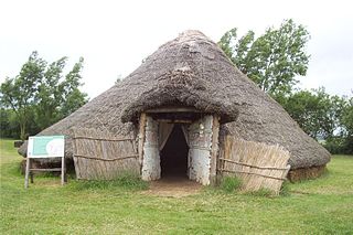
Flag Fen, east of Peterborough, England, is a Bronze Age site which was constructed about 3500 years ago and consists of more than 60,000 timbers arranged in five very long rows, creating a wooden causeway across the wet fenland. Part-way across the structure a small island was formed. Items associated with it have led scholars to conclude that the island was of religious significance. Archaeological work began in 1982 at the site, which is located 800 m east of Fengate. Flag Fen is now part of the Greater Fens Museum Partnership. A visitor centre has been constructed on site and some areas have been reconstructed, including a typical Iron Age roundhouse dwelling.
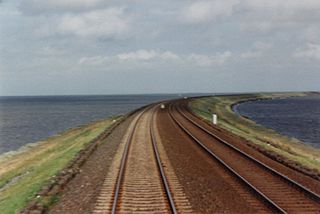
A causeway is a track, road or railway on the upper point of an embankment across "a low, or wet place, or piece of water". It can be constructed of earth, masonry, wood, or concrete. One of the earliest known wooden causeways is the Sweet Track in the Somerset Levels, England, which dates from the Neolithic age. Timber causeways may also be described as both boardwalks and bridges.

The Neolithic long house was a long, narrow timber dwelling built by the first farmers in Europe beginning at least as early as the period 5000 to 6000 BC. They first appeared in central Europe in connection with the early Neolithic cultures such as the Linear Pottery culture or Cucuteni culture. This type of architecture represents the largest free-standing structure in the world in its era. Long houses are present across numerous regions and time periods in the archaeological record.

A plank road is a road composed of wooden planks or puncheon logs, as an efficient technology for traversing soft, marshy, or otherwise difficult ground. Plank roads were commonly found in the Canadian province of Ontario as well as the Northeast and Midwest of the United States in the first half of the 19th century. They were often built by turnpike companies.
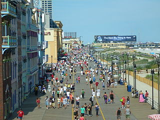
A boardwalk is an elevated footpath, walkway, or causeway typically built with wooden planks, which functions as a type of low water bridge or small viaduct that enables pedestrians to better cross wet, muddy or marshy lands. Such timber trackways have existed since at least Neolithic times.

The Sweet Track is an ancient trackway, or causeway, in the Somerset Levels, England, named after its finder, Ray Sweet. It was built in 3807 BC and is the second-oldest timber trackway discovered in the British Isles, dating to the Neolithic. The Sweet Track was predominantly built along the course of an earlier structure, the Post Track.

Historic roads are paths or routes that have historical importance due to their use over a period of time. Examples exist from prehistoric times until the early 20th century. They include ancient trackways, long-lasting roads, important trade routes, and migration trails. Many historic routes, such as the Silk Road, the Amber Road, and the Royal Road of the Persian Empire, covered great distances and their impact on human settlements remain today.

The River Brue originates in the parish of Brewham in Somerset, England, and reaches the sea some 50 kilometres (31 mi) west at Burnham-on-Sea. It originally took a different route from Glastonbury to the sea, but this was changed by Glastonbury Abbey in the twelfth century. The river provides an important drainage route for water from a low-lying area which is prone to flooding which man has tried to manage through rhynes, canals, artificial rivers and sluices for centuries.
Shapwick Heath is a 394.0-hectare biological Site of Special Scientific Interest and national nature reserve between Shapwick and Westhay in Somerset, notified in 1967. It is part of the Brue Valley Living Landscape conservation project. The project commenced in January 2009 and aims to restore, recreate and reconnect habitat. It aims to ensure that wildlife is enhanced and capable of sustaining itself in the face of climate change while guaranteeing farmers and other landowners can continue to use their land profitably. It is one of an increasing number of landscape scale conservation projects in the UK.

Westhay Moor is a 513.7-hectare (1,269-acre) biological Site of Special Scientific Interest 2.5 kilometres (1.6 mi) north-east of Westhay village and 4 kilometres (2.5 mi) from Wedmore in Somerset, England, notified in 1971. Westhay Moor is also notified as part of the Somerset Levels and Moors Special Protection Area under the EU Birds Directive and as a Ramsar site, and a National Nature Reserve.

Glastonbury Lake Village was an Iron Age village, situated on a crannog or man made island in the Somerset Levels, near Godney, some 3 miles (5 km) north west of Glastonbury in the southwestern English county of Somerset. It has been designated as a scheduled monument.
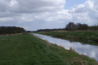
The Post Track is an ancient causeway in the valley of the River Brue on the Somerset Levels, England. It dates from around 3838 BCE, making it some 30 years older than the Sweet Track in the same area. Various sections have been scheduled as ancient monuments.
Meare Lake Village is the site of an Iron Age settlement on the Somerset Levels at Meare, Somerset, England. It is a Scheduled Ancient Monument.

There are over 670 scheduled monuments in the ceremonial county of Somerset in South West England. The county consists of a non-metropolitan county, administered by Somerset Council. The two administratively independent unitary authorities, which were established on 1 April 1996 following the breakup of the county of Avon, are North Somerset and Bath and North East Somerset. These unitary authorities include areas that were once part of Somerset before the creation of Avon in 1974.
The Hatfield Neolithic Trackway was discovered in 2004, and is one of the oldest known ancient timber trackways in England. The trackway is the second confirmed archaeological structure from Hatfield and Thorne Moors. The Lindholme Trackway dates to around 2900–2500 BC.
