
The Magellan spacecraft was a 1,035-kilogram (2,282 lb) robotic space probe launched by NASA on May 4, 1989. Its mission objectives were to map the surface of Venus by using synthetic-aperture radar and to measure the planetary gravitational field.

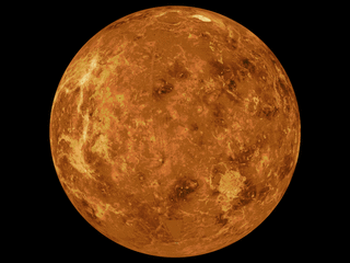
The geology of Venus is the scientific study of the surface, crust, and interior of the planet Venus. Within the Solar System, it is the one nearest to Earth and most like it in terms of mass, but has no magnetic field or recognizable plate tectonic system. Much of the ground surface is exposed volcanic bedrock, some with thin and patchy layers of soil covering, in marked contrast with Earth, the Moon, and Mars. Some impact craters are present, but Venus is similar to Earth in that there are fewer craters than on the other rocky planets that are largely covered by them. This is due in part to the thickness of the Venusian atmosphere disrupting small impactors before they strike the ground, but the paucity of large craters may be due to volcanic re-surfacing, possibly of a catastrophic nature. Volcanism appears to be the dominant agent of geological change on Venus. Some of the volcanic landforms appear to be unique to the planet. There are shield and composite volcanoes similar to those found on Earth, although these volcanoes are significantly shorter than those found on Earth or Mars. Given that Venus has approximately the same size, density, and composition as Earth, it is plausible that volcanism may be continuing on the planet today, as demonstrated by recent studies.

Danilova is an impact crater on Venus. It was named in 1991 after the Russian ballet dancer Maria Danilova.

Cleopatra is an impact crater on Venus, in Maxwell Montes. Cleopatra is a double-ring impact basin about 100 kilometers (62 mi) in diameter and 2.5 kilometers (1.6 mi) deep. A steep-walled, winding channel a few kilometers wide breaks through the rough terrain surrounding the crater rim. A large amount of lava originating in Cleopatra flowed through this channel and filled valleys in Fortuna Tessera. Cleopatra is superimposed on the structures of Maxwell Montes and appears to be undeformed, indicating that Cleopatra is relatively young. The crater is named after Egyptian queen Cleopatra VII.

Yablochkina is an impact crater on Venus. It was named in 1985 after Soviet actress Aleksandra Yablochkina.

Mead is an impact crater on Venus named in honor of the cultural anthropologist Margaret Mead.

Sapas Mons is a large volcano located in the Atla Regio region of Venus.

The geology of solar terrestrial planets mainly deals with the geological aspects of the four terrestrial planets of the Solar System – Mercury, Venus, Earth, and Mars – and one terrestrial dwarf planet: Ceres. Earth is the only terrestrial planet known to have an active hydrosphere.

The surface of Venus is dominated by volcanic features and has more volcanoes than any other planet in the Solar System. It has a surface that is 90% basalt, and about 65% of the planet consists of a mosaic of volcanic lava plains, indicating that volcanism played a major role in shaping its surface. There are more than 1,000 volcanic structures and possible periodic resurfacing of Venus by floods of lava. The planet may have had a major global resurfacing event about 500 million years ago, from what scientists can tell from the density of impact craters on the surface. Venus has an atmosphere rich in carbon dioxide, with a pressure that is 90 times that of Earth's atmosphere.

Dickinson crater is located at 74.6 degrees north latitude and 177.2 east longitude, in the northeastern Atalanta Region of Venus. It is 69 kilometers (43 mi) in diameter. The crater is complex, characterized by a partial central ring and a floor flooded by radar-dark and radar-bright materials. Hummocky, rough-textured ejecta extend all around the crater, except to the west. The lack of ejecta to the west may indicate that the impactor that produced the crater was an oblique impact from the west. Extensive radar-bright flows that emanate from the crater's eastern walls may represent large volumes of impact melt, or they may be the result of volcanic material released from the subsurface during the cratering event.

Stefania is a crater on Venus in the northern Sedna Planitia. With a diameter of 11 kilometers (6.8 mi) it is one of the smaller craters on Venus. Because many small meteoroids disintegrate during their passage through the dense atmosphere, there is an absence of craters smaller than 3 kilometers (1.9 mi) in diameter, and even craters smaller than 25 kilometers (16 mi) are relatively scarce. The apron of ejected material suggests that the impacting body made contact with the surface from an oblique angle. Upon closer observation it is possible to delineate secondary craters, impact scars from blocks ejected from the primary crater. A feature associated with this and many other Venusian craters is a radar-dark halo. Since dark radar return signifies a smooth surface, it has been hypothesized that an intense shock wave removed or pulverized previously rough surface material or that a blanket of fine material was deposited during or after the impact.

Jeanne is an impact crater on Venus.
Wanda is a crater in the Akna Montes on Venus first mapped first by the Soviet Venera 15/16 mission in 1984. It was formed by the impact of an asteroid. The crater has a rugged central peak and a smooth radar-dark floor, probably volcanic material. The crater does not appear to be much deformed by later crustal movement that uplifted the mountains and crumpled the plains. Material from the adjacent mountain ridge to the west, however, appears to have collapsed into the crater. Small pits seen to the north of the crater may be volcanic collapse pits a few kilometers across.

The Diacria quadrangle is one of a series of 30 quadrangle maps of Mars used by the United States Geological Survey (USGS) Astrogeology Research Program. The quadrangle is located in the northwestern portion of Mars' western hemisphere and covers 180° to 240° east longitude and 30° to 65° north latitude. The quadrangle uses a Lambert conformal conic projection at a nominal scale of 1:5,000,000 (1:5M). The Diacria quadrangle is also referred to as MC-2. The Diacria quadrangle covers parts of Arcadia Planitia and Amazonis Planitia.

The Arabia quadrangle is one of a series of 30 quadrangle maps of Mars used by the United States Geological Survey (USGS) Astrogeology Research Program. The Arabia quadrangle is also referred to as MC-12.

The Amazonis quadrangle is one of a series of 30 quadrangle maps of Mars used by the United States Geological Survey (USGS) Astrogeology Research Program. The Amazonis quadrangle is also referred to as MC-8.

The Mare Australe quadrangle is one of a series of 30 quadrangle maps of Mars used by the United States Geological Survey (USGS) Astrogeology Research Program. The Mare Australe quadrangle is also referred to as MC-30. The quadrangle covers all the area of Mars south of 65°, including the South polar ice cap, and its surrounding area. The quadrangle's name derives from an older name for a feature that is now called Planum Australe, a large plain surrounding the polar cap. The Mars polar lander crash landed in this region.

Venus snow is a brightening of the radar reflection from the surface of Venus at high elevations. The "snow" appears to be a mineral condensate of lead(II) sulfide and bismuth sulfide precipitated from the atmosphere at altitudes above 2,600 m (8,500 ft).
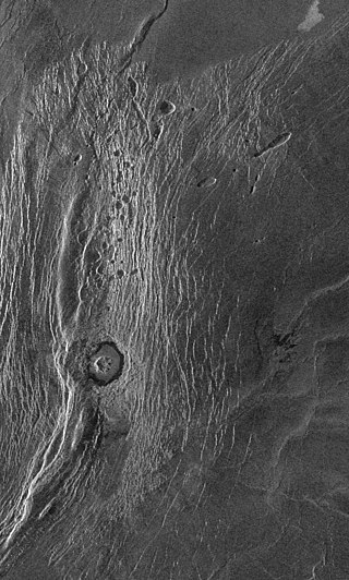
The surface of Venus is dominated by geologic features that include volcanoes, large impact craters, and aeolian erosion and sedimentation landforms. Venus has a topography reflecting its single, strong crustal plate, with a unimodal elevation distribution that preserves geologic structures for long periods of time. Studies of the Venusian surface are based on imaging, radar, and altimetry data collected from several exploratory space probes, particularly Magellan, since 1961. Despite its similarities to Earth in size, mass, density, and possibly composition, Venus has a unique geology that is unlike Earth's. Although much older than Earth's, the surface of Venus is relatively young compared to other terrestrial planets, possibly due to a global-scale resurfacing event that buried much of the previous rock record. Venus is believed to have approximately the same bulk elemental composition as Earth, due to the physical similarities, but the exact composition is unknown. The surface conditions on Venus are more extreme than on Earth, with temperatures ranging from 453 to 473 °C and pressures of 95 bar. Venus lacks water, which makes crustal rock stronger and helps preserve surface features. The features observed provide evidence for the geological processes at work. Twenty feature types have been categorized thus far. These classes include local features, such as craters, coronae, and undae, as well as regional-scale features, such as planitiae, plana, and tesserae.
The mapping of Venus refers to the process and results of human description of the geological features of the planet Venus. It involves surface radar images of Venus, construction of geological maps, and the identification of stratigraphic units, volumes of rock with a similar age.
