
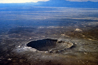
An impact crater is a depression in the surface of a solid astronomical body formed by the hypervelocity impact of a smaller object. In contrast to volcanic craters, which result from explosion or internal collapse, impact craters typically have raised rims and floors that are lower in elevation than the surrounding terrain. Impact craters are typically circular, though they can be elliptical in shape or even irregular due to events such as landslides. Impact craters range in size from microscopic craters seen on lunar rocks returned by the Apollo Program to simple bowl-shaped depressions and vast, complex, multi-ringed impact basins. Meteor Crater is a well-known example of a small impact crater on Earth.
A caldera is a large cauldron-like hollow that forms shortly after the emptying of a magma chamber in a volcanic eruption. An eruption that ejects large volumes of magma over a short period of time can cause significant detriment to the structural integrity of such a chamber, greatly diminishing its capacity to support its own roof, and any substrate or rock resting above. The ground surface then collapses into the emptied or partially emptied magma chamber, leaving a large depression at the surface. Although sometimes described as a crater, the feature is actually a type of sinkhole, as it is formed through subsidence and collapse rather than an explosion or impact. Compared to the thousands of volcanic eruptions that occur over the course of a century, the formation of a caldera is a rare event, occurring only a few times within a given window of 100 years. Only eight caldera-forming collapses are known to have occurred between 1911 and 2018, with a caldera collapse at Kīlauea, Hawaii in 2018. Volcanoes that have formed a caldera are sometimes described as "caldera volcanoes".
Volcanism, vulcanism, volcanicity, or volcanic activity is the phenomenon where solids, liquids, gases, and their mixtures erupt to the surface of a solid-surface astronomical body such as a planet or a moon. It is caused by the presence of a heat source, usually internally generated, inside the body; the heat is generated by various processes, such as radioactive decay or tidal heating. This heat partially melts solid material in the body or turns material into gas. The mobilized material rises through the body's interior and may break through the solid surface.

The Chicxulub crater is an impact crater buried underneath the Yucatán Peninsula in Mexico. Its center is offshore, but the crater is named after the onshore community of Chicxulub Pueblo. It was formed slightly over 66 million years ago when an asteroid, about ten kilometers in diameter, struck Earth. The crater is estimated to be 200 kilometers in diameter and 1 kilometer in depth. It is believed to be the second largest impact structure on Earth, and the only one whose peak ring is intact and directly accessible for scientific research.

Suvasvesi is a lake in Eastern Finland near the city of Kuopio. Suvasvesi consists of two circular open lakes, Kuukkarinselkä in north and Haapaselkä in south. The lakes are separated by a group of islands. The lake has 688 islands in total. The area of the lake is 234 square kilometres (90 sq mi) making it the 18th largest lake in Finland. Kuukkarinselkä is the third deepest lake in Finland measuring 89.0 metres (292.0 ft) in the deepest point.

A flood basalt is the result of a giant volcanic eruption or series of eruptions that covers large stretches of land or the ocean floor with basalt lava. Many flood basalts have been attributed to the onset of a hotspot reaching the surface of the Earth via a mantle plume. Flood basalt provinces such as the Deccan Traps of India are often called traps, after the Swedish word trappa, due to the characteristic stairstep geomorphology of many associated landscapes.

Alba Mons is a volcano located in the northern Tharsis region of the planet Mars. It is the biggest volcano on Mars in terms of surface area, with volcanic flow fields that extend for at least 1,350 km (840 mi) from its summit. Although the volcano has a span comparable to that of the United States, it reaches an elevation of only 6.8 km (22,000 ft) at its highest point. This is about one-third the height of Olympus Mons, the tallest volcano on the planet. The flanks of Alba Mons have very gentle slopes. The average slope along the volcano's northern flank is 0.5°, which is over five times lower than the slopes on the other large Tharsis volcanoes. In broad profile, Alba Mons resembles a vast but barely raised welt on the planet's surface. It is a unique volcanic structure with no counterpart on Earth or elsewhere on Mars.

The geology of the Moon is quite different from that of Earth. The Moon lacks a true atmosphere, and the absence of free oxygen and water eliminates erosion due to weather. Instead, the surface is eroded much more slowly through the bombardment of the lunar surface by micrometeorites. It does not have any known form of plate tectonics, it has a lower gravity, and because of its small size, it cooled faster. In addition to impacts, the geomorphology of the lunar surface has been shaped by volcanism, which is now thought to have ended less than 50 million years ago. The Moon is a differentiated body, with a crust, mantle, and core.

The geology of Venus is the scientific study of the surface, crust, and interior of the planet Venus. Within the Solar System, it is the one nearest to Earth and most like it in terms of mass, but has no magnetic field or recognizable plate tectonic system. Much of the ground surface is exposed volcanic bedrock, some with thin and patchy layers of soil covering, in marked contrast with Earth, the Moon, and Mars. Some impact craters are present, but Venus is similar to Earth in that there are fewer craters than on the other rocky planets that are largely covered by them. This is due in part to the thickness of the Venusian atmosphere disrupting small impactors before they strike the ground, but the paucity of large craters may be due to volcanic re-surfacing, possibly of a catastrophic nature. Volcanism appears to be the dominant agent of geological change on Venus. Some of the volcanic landforms appear to be unique to the planet. There are shield and composite volcanoes similar to those found on Earth, although these volcanoes are significantly shorter than those found on Earth or Mars. Given that Venus has approximately the same size, density, and composition as Earth, it is plausible that volcanism may be continuing on the planet today, as demonstrated by recent studies.

Cleopatra is an impact crater on Venus, in Maxwell Montes. Cleopatra is a double-ring impact basin about 100 kilometers (62 mi) in diameter and 2.5 kilometers (1.6 mi) deep. A steep-walled, winding channel a few kilometers wide breaks through the rough terrain surrounding the crater rim. A large amount of lava originating in Cleopatra flowed through this channel and filled valleys in Fortuna Tessera. Cleopatra is superimposed on the structures of Maxwell Montes and appears to be undeformed, indicating that Cleopatra is relatively young. The crater is named after Egyptian queen Cleopatra VII.

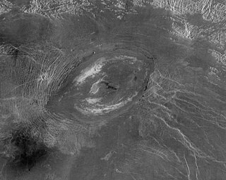
Sapas Mons is a large volcano located in the Atla Regio region of Venus.

The geology of solar terrestrial planets mainly deals with the geological aspects of the four terrestrial planets of the Solar System – Mercury, Venus, Earth, and Mars – and one terrestrial dwarf planet: Ceres. Earth is the only terrestrial planet known to have an active hydrosphere.

The surface of Venus is dominated by volcanic features and has more volcanoes than any other planet in the Solar System. It has a surface that is 90% basalt, and about 65% of the planet consists of a mosaic of volcanic lava plains, indicating that volcanism played a major role in shaping its surface. There are more than 1,000 volcanic structures and possible periodic resurfacing of Venus by floods of lava. The planet may have had a major global resurfacing event about 500 million years ago, from what scientists can tell from the density of impact craters on the surface. Venus has an atmosphere rich in carbon dioxide, with a pressure that is 90 times that of Earth's atmosphere.

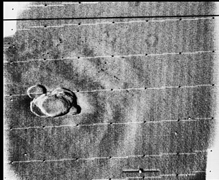
Dickinson crater is located at 74.6 degrees north latitude and 177.2 east longitude, in the northeastern Atalanta Region of Venus. It is 69 kilometers (43 mi) in diameter. The crater is complex, characterized by a partial central ring and a floor flooded by radar-dark and radar-bright materials. Hummocky, rough-textured ejecta extend all around the crater, except to the west. The lack of ejecta to the west may indicate that the impactor that produced the crater was an oblique impact from the west. Extensive radar-bright flows that emanate from the crater's eastern walls may represent large volumes of impact melt, or they may be the result of volcanic material released from the subsurface during the cratering event.
Sacajawea Patera is a large, elongate caldera located in Western Ishtar Terra on the smooth plateau of Lakshmi Planum, on the planet Venus. The image is centred at 64.5 degrees North latitude and 337 degrees East longitude. It is approximately 420 km (260 mi) wide at the base. Sacajawea is a depression approximately 1–2 kilometres (0.62–1.24 mi) deep and 120 by 215 kilometres in diameter; it is elongate in a southwest–northeast direction. The depression is bounded by a zone of circumferential curvilinear structures interpreted to be graben and fault scarps. These structures are spaced 0.5–4 kilometers apart, are 0.6–4.0 kilometers in width and up to 100 km (62 mi) in length.
Volcanic activity, or volcanism, has played a significant role in the geologic evolution of Mars. Scientists have known since the Mariner 9 mission in 1972 that volcanic features cover large portions of the Martian surface. These features include extensive lava flows, vast lava plains, and, such as Olympus Mons, the largest known volcanoes in the Solar System. Martian volcanic features range in age from Noachian to late Amazonian, indicating that the planet has been volcanically active throughout its history, and some speculate it probably still is so today. Both Mars and Earth are large, differentiated planets built from similar chondritic materials. Many of the same magmatic processes that occur on Earth also occurred on Mars, and both planets are similar enough compositionally that the same names can be applied to their igneous rocks.
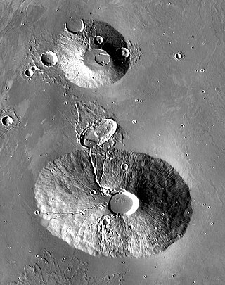
Rahe is a crater on the planet Mars in the Tharsis quadrangle, positioned at 25.05° north latitude and 262.52° east longitude, between the volcanoes Ceraunius Tholus and Uranius Tholus. It measures approximately 34 kilometers in diameter and was named after Jürgen Rahe, a German-American astronomer and NASA science program director.
The surface of Venus is dominated by geologic features that include volcanoes, large impact craters, and aeolian erosion and sedimentation landforms. Venus has a topography reflecting its single, strong crustal plate, with a unimodal elevation distribution that preserves geologic structures for long periods of time. Studies of the Venusian surface are based on imaging, radar, and altimetry data collected from several exploratory space probes, particularly Magellan, since 1961. Despite its similarities to Earth in size, mass, density, and possibly composition, Venus has a unique geology that is unlike Earth's. Although much older than Earth's, the surface of Venus is relatively young compared to other terrestrial planets, possibly due to a global-scale resurfacing event that buried much of the previous rock record. Venus is believed to have approximately the same bulk elemental composition as Earth, due to the physical similarities, but the exact composition is unknown. The surface conditions on Venus are more extreme than on Earth, with temperatures ranging from 453 to 473 °C and pressures of 95 bar. Venus lacks water, which makes crustal rock stronger and helps preserve surface features. The features observed provide evidence for the geological processes at work. Twenty feature types have been categorized thus far. These classes include local features, such as craters, coronae, and undae, as well as regional-scale features, such as planitiae, plana, and tesserae.
A crater is a landform consisting of a hole or depression on a planetary surface, usually caused either by an object hitting the surface, or by geological activity on the planet. A crater has classically been described as: "a bowl-shaped pit that is formed by a volcano, an explosion, or a meteorite impact". On Earth, craters are "generally the result of volcanic eruptions", while "meteorite impact craters are common on the Moon, but are rare on Earth".

Volcanism on the Moon is represented by the presence of volcanoes, pyroclastic deposits and vast lava plains on the lunar surface. The volcanoes are typically in the form of small domes and cones that form large volcanic complexes and isolated edifices. Calderas, large-scale collapse features generally formed late in a volcanic eruptive episode, are exceptionally rare on the Moon. Lunar pyroclastic deposits are the result of lava fountain eruptions from volatile-laden basaltic magmas rapidly ascending from deep mantle sources and erupting as a spray of magma, forming tiny glass beads. However, pyroclastic deposits formed by less common non-basaltic explosive eruptions are also thought to exist on the Moon. Lunar lava plains cover large swaths of the Moon's surface and consist mainly of voluminous basaltic flows. They contain a number of volcanic features related to the cooling of lava, including lava tubes, rilles and wrinkle ridges.
