Komagane is a city located in Nagano Prefecture, Japan. As of 1 February 2019, the city had an estimated population of 32,210 in 12937 households, and a population density of 190 persons per km². The total area of the city is 165.86 square kilometres (64.04 sq mi).

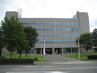
Shiojiri is a city located in Nagano Prefecture, Japan. As of 1 March 2019, the city had an estimated population of 67,240 in 27,602 households, and a population density of 230 persons per km². The total area of the city is 289.98 square kilometres (111.96 sq mi).

Nakatsugawa is a city located in Gifu, Japan. As of 31 December 2018, the city had an estimated population of 78,930, and a population density of 120 persons per km2 in 30,788 households The total area of the city was 676.45 square kilometres (261.18 sq mi).
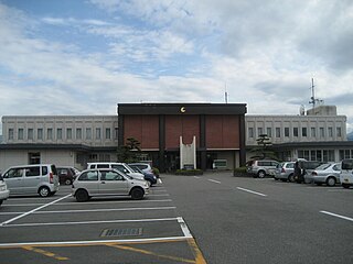
Ina is a city located in Nagano Prefecture, Japan. As of 1 March 2019, the city had an estimated population of 68,177 in 27587 households, and a population density of 100 persons per km². The total area of the city is 667.93 square kilometres (257.89 sq mi). In 2016, the former town of Takatō, now part of Ina, was selected as one of The Most Beautiful Villages in Japan.

Mitake is a town located in Kani District, Gifu Prefecture, Japan. As of 1 January 2019, the town had an estimated population of 18,363 and a population density of 330 persons per km2, in 7,348 households. The total area of the town was 56.69 square kilometres (21.89 sq mi).

Minowa is a town located in Nagano Prefecture, Japan. As of 1 April 2019, the town had an estimated population of 25,051 in 9737 households, and a population density of 290 persons per km². The total area of the town is 85.91 square kilometres (33.17 sq mi).

Iijima is a town located in Nagano Prefecture, Japan. As of 1 April 2019, the town had an estimated population of 9,446 in 3599 households, and a population density of 110 persons per km². The total area of the town is 86.96 square kilometres (33.58 sq mi).

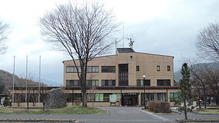
Minamiminowa is a village located in Nagano Prefecture, Japan. As of 1 April 2019, the village had an estimated population of 15,463 in 6115 households, and a population density of 371 persons per km². The total area of the village is 40.99 square kilometres (15.83 sq mi).

Nakagawa is a village located in Nagano Prefecture, Japan. As of 1 April 2019, the village had an estimated population of 4,910 in 1628 households, and a population density of 64 persons per km². The total area of the village is 77.05 square kilometres (29.75 sq mi). Nakagawa is listed as one of The Most Beautiful Villages in Japan.
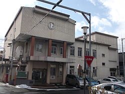
Miyada is a village located in Nagano Prefecture, Japan. As of 1 April 2019, the village had an estimated population of 9,051 in 3439 households, and a population density of 170 persons per km². The total area of the village is 54.50 square kilometres (21.04 sq mi).

Matsukawa is a town located in Nagano Prefecture, Japan. As of 1 April 2019, the town had an estimated population of 13,043 in 4364 households, and a population density of 180 persons per km². The total area of the town is 72.79 square kilometres (28.10 sq mi). Like many other small Southern Nagano villages, it is famous for its apples.

Ōshika is a village located in Nagano Prefecture, Japan. As of 1 October 2018, the village had an estimated population of 977, and a population density of 3.9 persons per km². The total total area of the village is 248.28 square kilometres (95.86 sq mi). Ōshika is listed as one of The Most Beautiful Villages in Japan.
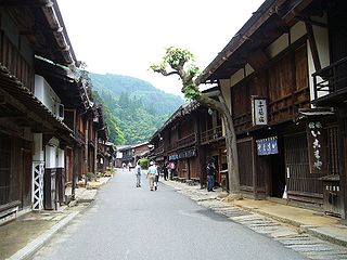
Nagiso is a town located in Nagano Prefecture, Japan. As of 1 April 2019, the town had an estimated population of 4,111 in 1751 households, and a population density of 19 persons per km². The total area of the town was 215.93 square kilometres (83.37 sq mi). Nagiso is listed as one of The Most Beautiful Villages in Japan.
Kiso is a village located in Nagano Prefecture, Japan. As of 1 April 2019, the village had an estimated population of 2,877 in 1116 households, and a population density of 20 persons per km². The total area of the village is 140.50 square kilometres (54.25 sq mi).

Ōtaki is a village located in Nagano Prefecture, Japan. As of 1 April 2019, the village had an estimated population of 753 in 378 household, and a population density of 2.4 persons per km². The total area of the village is 310.82 square kilometres (120.01 sq mi). At present, Ōtaki's land area is 95% forestland; 86% of which is designated national forest.

Ōkuwa is a village located in Nagano Prefecture, Japan. As of 1 April 2019, the village had an estimated population of 3,693 in 1558 households, and a population density of 16 persons per km². The total area of the village is 234.47 square kilometres (90.53 sq mi).

Yamagata is a village located in Nagano Prefecture, Japan. As of 1 October 2016, the village had an estimated population of 8,726 in 3071 households, and a population density of 333 persons per km². The total area of the village is 24.98 square kilometres (9.64 sq mi).

Asahi is a village located in Nagano Prefecture, Japan. As of 1 April 2019, the village had an estimated population of 4,569 in 1533 households, and a population density of 63.4 persons per km². The total area of the village is 70.62 square kilometres (27.27 sq mi).

Nagawa is a town located in Nagano Prefecture, Japan. As of 1 April 2019, the town had an estimated population of 6,088 in 2650 households, and a population density of 32.6 persons per km². The total area of the town is 183.86 square kilometres (70.99 sq mi).

Kiso is a town located in Nagano Prefecture, Japan. As of 5 April 2019, the town had an estimated population of 11,045 in 4892 households, and a population density of 23 persons per km². The total area of the town is 476.03 square kilometres (183.80 sq mi). Kiso Town is listed as one of The Most Beautiful Villages in Japan.