Aguas Calientes caldera

Last updated
Aguas Calientes caldera
Relief Map of Argentina.jpg
Red triangle with thick white border.svg
Aguas Calientes caldera
The South American country of Argentina
Highest point
Elevation 4,473 m (14,675 ft) [1]
Coordinates 24°15′S66°30′W / 24.250°S 66.500°W / -24.250; -66.500 [2]
Geography
Locationnorthwest Argentina
Parent range Andes
Geology
Mountain type caldera
Volcanic belt Andean Volcanic Belt

Aguas Calientes is a major Miocene caldera in Salta Province, Argentina. It is in the Central Volcanic Zone of the Andes, a zone of volcanism covering southern Peru, Bolivia, northwest Argentina and northern Chile. This zone contains stratovolcanoes and calderas.

Contents

The activity of the Central Volcanic Zone is linked to the subduction of the Farallon Plate and later its splinter, the Nazca Plate, below the South American Plate. The Aguas Calientes caldera is located on a Precambrian basement that was thrust over more recent (Cretaceous and younger) layers of sediment. [3]

Aguas Calientes caldera was the source of two major ignimbrites; the Tajamar Ignimbrite (including the Chorrillos Ignimbrite inside the caldera) and the Verde Ignimbrite. The first was erupted 10.5–10.1 Ma ago and is a body of ignimbrite of about 350 cubic kilometres (84 cu mi). The second was erupted 17.2 Ma ago and has a volume of 140–300 cubic kilometres (34–72 cu mi).

Geography and structure

Aguas Calientes caldera lies in the northwestern Salta Province of Argentina, in the San Antonio de los Cobres district [4] to the southeast of the town of the same name. [5]

Aguas Calientes caldera is part of the Central Volcanic Zone (CVC), which is located in southern Peru, northern Chile, southwestern Bolivia and northwestern Argentina in highlands over 4,000 metres (13,000 ft) high. At least six potentially active calderas, 44 active major and 18 active minor volcanoes lie in this area, [6] of which Lascar volcano is the most active. [7] The largest eruption in historical times in the CVZ occurred in 1600 on Huaynaputina volcano in Peru. [8]

Aguas Calientes caldera is a roughly circular caldera limited on the western and eastern side by north–south trending fault systems. [3] Two superimposed calderas form the volcanic system. [9]

Cerro Verde inside the caldera is a dome formed by the uplifting of the Verde ignimbrites in the caldera after their deposition and cooling. Cerro Aguas Calientes was formed in the same way from the Tajmar ignimbrites, conclusions based in both cases on the outward dip of the ignimbrites contained in the domes. [3]

Geology

The Central Volcanic Zone (CVZ), active mainly since the Miocene, is the volcanically active area of the Andes between 16 and 28°S. [10] Its activity is dependent on the subduction of the Nazca Plate, previously the Farallon Plate, below the South American Plate. This subduction process is responsible for the formation of the Andes and the volcanic activity on the eastern margin of the South American continent. [6]

Estimates of the volumes erupted and surface areas covered by the CVZ volcanoes in the Neogene vary. 7,300 cubic kilometres (1,800 cu mi) with a surface area 44,000 square kilometres (17,000 sq mi) for the latitudes 18–28°S and 30,000 cubic kilometres (7,200 cu mi) with a surface area 70,000 square kilometres (27,000 sq mi) for the latitudes north of 25°S have been calculated. [10]

In the southern segment of the CVZ, volcanic activity has varied over time. Before 26 Ma, volcanic activity was limited to a belt 100–230 kilometres (62–143 mi) from the Peru–Chile Trench. An increased subduction rate around 26 Ma, possibly related to the breakup of the Farallon Plate and change in the subduction direction, resulted in increasing activity and eastward migration of the activity. 14.5 to 5.3 Ma the volcanic activity expanded laterally and reached a maximum 14.5 to 11.5 Ma with a width 307 kilometres (191 mi) and a maximum trench-volcano distance of 520 kilometres (320 mi). During this phase volcanism in the western part of the CVZ was effusive. 11.5–8.3 Ma the volcanism moved back westwards and after 5.3 Ma it was restricted to a narrow belt 300–470 kilometres (190–290 mi) from the trench. [10] The currently active belt is located 240–300 kilometres (150–190 mi) east of the trench. [6]

Local

Aguas Calientes caldera is located on the Late Neoproterozoic to Early Cambrian Puncoviscana Formation with turbiditic sandstone that was affected by metamorphism. A volcano-sedimentary Ordovician sequence of marine origin is the only other Paleozoic structure in the area. The caldera itself is located on the Precambrian-Ordovician basement. [3]

The volcano is linked to the major Calama–Olacapato–El Toro fault system that cuts the Andean chain in a northwest–southeast direction. This system also affects the Negra Muerta volcanic complex, Cerro Tuzgle, Chimpa volcanoes and several smaller volcanic systems. The formation of this fault system and other thrust faults parallel to the Andes chain is linked to the compression and orogeny of the Andean chain since the Miocene. [11]

Geologic record

Aguas Calientes caldera was between 11 and 10 Ma the source of large scale ignimbrite sheets. [12] Aguas Calientes caldera is considered to be an overpressure caldera, where eruption is triggered by intrusions from the volcano sill weaken the host rocks and cause the formation of fissures. [13]

Composition

Minerals in the Tajamar ignimbrite include biotite, hornblende, plagioclase, quartz and some augite. [2] The eruption products are uniformly dacitic in nature. Hydrothermal alterations have generated Sb-Au and Pb-Ag-Zn deposits that may be of economic importance. [14] These deposits occur in the form of mineralized breccia and quartz. [15] The La Poma-Incachule mining district northeast of the caldera is part of the volcanic system and contains argentiferous galena, sphalerite, antimonite and arsenopyrite. These deposits formed through hydrothermal, deuteric alteration and supergene processes and were influenced during their formation by local fault systems. [9]

Eruptive history

Aguas Calientes caldera erupted twice dacitic ignimbrites. was the source of two major ignimbrites; the Tajamar Ignimbrite (including the Chorrillos Ignimbrite inside the caldera), and the Verde Ignimbrite. The first was erupted 10.5–10.1 Ma and is a body of ignimbrite of about 350 cubic kilometres (84 cu mi). The second was erupted 17.2 Ma and has a volume of 140–300 cubic kilometres (34–72 cu mi). [2] The Abra de Gallo ignimbrite was formerly considered the third and erupted 10.0-10.5 Ma; [1] Petrinovic et al. consider it part of the Tajamar ignimbrite. Both eruptions probably resulted from a disruption of the magma chamber integrity by vertical faults created through the activity of horizontal fault systems in the region. [3] There is no evidence of plinian eruption columns in the eruption deposits [14] and the chemistry of the deposits indicates they originated in a homogeneous magma chamber. [5]

The first eruption, which took place 17.15 Ma, was the first caldera forming episode and the eruption occurred through a central vent. Its deposit, the Verde Ignimbrite, is pumice rich and green in colour. The deposits in thickness range from more than 520 metres (1,710 ft) on Cerro Verde to 80 metres (260 ft) in the southern outcrops. It covers a surface area of about 650 square kilometres (250 sq mi). After the eruption, the Verde ignimbrites were tectonically deformed and partly buried by the Tajamar ignimbrites. [3] [14]

The second eruption was more extensive and covered at a minimum 2,265 square kilometres (875 sq mi). Starting from the caldera rim, it is clearly distinguishable in two units; the intracaldera Chorrillos and the extracaldera Tajamar units which were formerly considered to be separate events. The Chorrilos deposits are gray coloured and have pumice fragments of less than 5 cm diameter; they also contain breccia lenses. The Tajmar deposits overlie the Chorrillos deposits and have a red to pale pink colour. The ash flows from the eruption flowed out of the caldera, forming flow structures similar to large lava flows. The deposits underwent some devitrification due to vapour action. This ignimbrite has a maximum thickness of 450 metres (1,480 ft) on Cerro Aguas Calientes in the caldera centre and thins to less than 100 metres (330 ft) away from the volcano. [3] [14]

Post-caldera activity included hydrothermalgeothermal activity and may have migrated westward to the neighbouring Quevar volcanic centre. Subsequent to the caldera formation, the caldera floor was uplifted for 800–1,000 metres (2,600–3,300 ft). [14] Geothermal activity still occurs at the Incachule field. [15]

See also

Related Research Articles

<span class="mw-page-title-main">Galán</span> Mountain in Argentina

Cerro Galán is a caldera in the Catamarca Province of Argentina. It is one of the largest exposed calderas in the world and forms part of the Central Volcanic Zone of the Andes, one of the three volcanic belts found in South America. One of several major caldera systems in the Central Volcanic Zone, the mountain is grouped into the Altiplano–Puna volcanic complex.

<span class="mw-page-title-main">La Pacana</span> Large Miocene-age caldera in northern Chile

La Pacana is a Miocene age caldera in northern Chile's Antofagasta Region. Part of the Central Volcanic Zone of the Andes, it is part of the Altiplano-Puna volcanic complex, a major caldera and silicic ignimbrite volcanic field. This volcanic field is located in remote regions at the Zapaleri tripoint between Chile, Bolivia and Argentina.

<span class="mw-page-title-main">Altiplano–Puna volcanic complex</span>

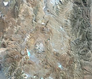
The Altiplano–Puna volcanic complex, also known as APVC, is a complex of volcanic systems in the Puna of the Andes. It is located in the Altiplano area, a highland bounded by the Bolivian Cordillera Real in the east and by the main chain of the Andes, the Western Cordillera, in the west. It results from the subduction of the Nazca Plate beneath the South American Plate. Melts caused by subduction have generated the volcanoes of the Andean Volcanic Belt including the APVC. The volcanic province is located between 21° S–24° S latitude. The APVC spans the countries of Argentina, Bolivia and Chile.

<span class="mw-page-title-main">Cerro Blanco (volcano)</span> Caldera in Catamarca Province, Argentina

Cerro Blanco is a caldera in the Andes of the Catamarca Province in Argentina. Part of the Central Volcanic Zone of the Andes, it is a volcano collapse structure located at an altitude of 4,670 metres (15,320 ft) in a depression. The caldera is associated with a less well-defined caldera to the south and several lava domes.

Cerro Guacha is a Miocene caldera in southwestern Bolivia's Sur Lípez Province. Part of the volcanic system of the Andes, it is considered to be part of the Central Volcanic Zone (CVZ), one of the three volcanic arcs of the Andes, and its associated Altiplano-Puna volcanic complex (APVC). A number of volcanic calderas occur within the latter.

<span class="mw-page-title-main">Cerro Panizos</span>

Panizos is a Late Miocene caldera in the Potosí Department of Bolivia and the Jujuy Province of Argentina. It is part of the Altiplano-Puna volcanic complex of the Central Volcanic Zone in the Andes. 50 volcanoes active in recent times are found in the Central Volcanic Zone, and several major caldera complexes are situated in the area. The caldera is located in a difficult-to-access part of the Andes.

<span class="mw-page-title-main">Incapillo</span> Pleistocene caldera in Argentina

Incapillo is a Pleistocene-age caldera in the La Rioja Province of Argentina. It is the southernmost volcanic centre in the Andean Central Volcanic Zone (CVZ) that erupted during the Pleistocene. Incapillo is one of several ignimbrite or caldera systems that, along with 44 active stratovolcanoes, are part of the CVZ.

Jotabeche is a Miocene-Pliocene caldera in the Atacama Region of Chile. It is part of the volcanic Andes, more specifically of the extreme southern end of the Central Volcanic Zone (CVZ). This sector of the Andean Volcanic Belt contains about 44 volcanic centres and numerous more minor volcanic systems, as well as some caldera and ignimbrite systems. Jotabeche is located in a now inactive segment of the CVZ, the Maricunga Belt.

Laguna Amarga is a caldera and associated ignimbrite in the Andes of northwestern Argentina.

Luingo is a caldera in the Andes of Argentina. It is located southeast of the Galan caldera. The caldera is not recognizable from satellite images and is associated with the Pucarilla-Cerro Tipillas volcanic complex.

<span class="mw-page-title-main">Negra Muerta volcanic complex</span>

Negra Muerta is a caldera in Argentina. It is part of the volcanic centres of the Andean Volcanic Belt, which has formed a number of calderas in large ignimbrite producing eruptions. These calderas include Aguas Calientes, Cerro Panizos, Galan, Negra Muerta and La Pacana. Some of these volcanic centres appear to be associated with large fault zones that cross the Puna.

Negro de Chorrillos is a volcano in the Andes.

Pairique volcanic complex is a volcanic complex in the Jujuy Province, Argentina.

San Jerónimo is a volcano in Argentina. It is located 18 kilometres (11 mi) from San Antonio de los Cobres and the lava flows are visible from the road.

Tocomar is a Pleistocene volcano in the Jujuy Province, Argentina. It is part of the Andean Volcanic Belt, more specifically to its sub-belt the Central Volcanic Zone. The Central Volcanic Zone consists of about 44 active volcanoes and large calderas of the Altiplano-Puna volcanic complex. Volcanism there is caused by the subduction of the Nazca Plate beneath the South America Plate in the Peru-Chile Trench. At Tocomar, volcanism is further influenced by a large fault zone, the Calama-Olacapato-El Toro fault, which runs diagonally across the volcanic arc.

Vilama is a Miocene caldera in Bolivia and Argentina. Straddling the border between the two countries, it is part of the Central Volcanic Zone, one of the four volcanic belts in the Andes. Vilama is remote and forms part of the Altiplano-Puna volcanic complex, a province of large calderas and associated ignimbrites that were active since about 8 million years ago, sometimes in the form of supervolcanoes.

Chimpa is a volcano in Argentina, close to the border between the Jujuy Province and the Salta Province. The volcano is of Miocene age, one date given being 12 million years ago and another is 7 million years ago.

Cerro Tuzgle is a dormant stratovolcano in the Susques Department of Jujuy Province in northwestern Argentina. Tuzgle is a prominent volcano of the back arc of the Andes and lies about 280 kilometres (170 mi) east of the main volcanic arc. Part of the Central Volcanic Zone of the Andes, its summit is 5,486 metres (17,999 ft) above sea level and it grew during different stages over a caldera and lava domes. Some major lava flows emanate from the summit crater, and one confirmed and one possible flank collapse unit as well as an ignimbrite sheet are associated with Tuzgle.

Coranzulí is a Miocene caldera in northern Argentina's Jujuy Province. Part of the Argentine Andes' volcanic segment, it is considered a member of the Central Volcanic Zone (CVZ). At the heart of the CVZ lies the Altiplano-Puna volcanic complex, a group of volcanoes of which Coranzulí is a part: the complex has produced large ignimbrite sheets with a combined volume approaching 15,000 cubic kilometres (3,600 cu mi).

References

  1. 1 2 Kay, Suzanne Mahlburg; Coira, Beatriz; Mpodozis, Constantino (2008). "Field trip guide: Neogene evolution of the central Andean Puna plateau and southern Central Volcanic Zone". In Suzanne Mahlburg Kay; Víctor A. Ramos (eds.). GSA Field Guide 13: Field Trip Guides to the Backbone of the Americas in the Southern and Central Andes: Ridge Collision, Shallow Subduction, and Plateau Uplift. Vol. 13. Geological Society of America. pp. 117–181. doi:10.1130/2008.0013(05). ISBN   978-0-8137-0013-7.
  2. 1 2 3 Kay, Suzanne Mahlburg; Coira, Beatriz L.; Caffe, Pablo J.; Chen, Chang-Hwa (2010). "Regional chemical diversity, crustal and mantle sources and evolution of central Andean Puna plateau ignimbrites". Journal of Volcanology and Geothermal Research. 198 (1–2): 81–111. Bibcode:2010JVGR..198...81K. doi:10.1016/j.jvolgeores.2010.08.013. ISSN   0377-0273.
  3. 1 2 3 4 5 6 7 Petrinovic, I.A.; Martí, J.; Aguirre-Díaz, G.J.; Guzmán, S.; Geyer, A.; Paz, N. Salado (2010). "The Cerro Aguas Calientes caldera, NW Argentina: An example of a tectonically controlled, polygenetic collapse caldera, and its regional significance". Journal of Volcanology and Geothermal Research. 194 (1–3): 15–26. Bibcode:2010JVGR..194...15P. doi:10.1016/j.jvolgeores.2010.04.012. hdl: 11336/52025 . ISSN   0377-0273.
  4. Colin E. Dunn (30 August 2011). Biogeochemistry in Mineral Exploration. Elsevier. p. 359. ISBN   978-0-08-054649-0.
  5. 1 2 I. A. PETRINOVIC; J. MITJAVILA; J.G. VIRAMONTE; J. MARTÍ; R. BECCHIO; M. ARNOSIO; F . COLOMBO (1999). "Geochemistry and Geochronology descriptions of the Backarc Neogene volcanic sequences in the eastern border of the Quevar Transversal Volcanic Range (NWArgentina)" (PDF). Acta Geológica Hispánica. 34 (2–3): 255–272.
  6. 1 2 3 Stern, Charles R. (2004). "Active Andean volcanism: its geologic and tectonic setting". Revista Geológica de Chile. 31 (2). doi: 10.4067/S0716-02082004000200001 . ISSN   0716-0208.
  7. Pritchard, Matthew E.; Simons, Mark (2002). "A satellite geodetic survey of large-scale deformation of volcanic centres in the central Andes". Nature. 418 (6894): 167–171. doi:10.1038/nature00872. ISSN   0028-0836. PMID   12110886. S2CID   4342717.
  8. Adams, Nancy; de Silva, Shanaka; Self, Stephen; Salas, Guido; Schubring, Steven; Permenter, Jason; Arbesman, Kendra (2001). "The physical volcanology of the 1600 eruption of Huaynaputina, southern Peru". Bulletin of Volcanology. 62 (8): 493–518. Bibcode:2001BVol...62..493A. doi:10.1007/s004450000105. ISSN   0258-8900. S2CID   129649755.
  9. 1 2 Salado Paz, Natalia; Petrinovic, Iván; Godeas, Marta; Avila, Julio Cesar (2011). "Alteraciones Hidrotermales Asociadas a un Sistema Epitermal de Au-Sb- Pb-Ag-Zn en la Caldera de Colapso del Cerro Aguas Calientes, Puna Salteña". Inst. de Bio y Geociencias del Noa (in Spanish). Consejo Nacional de Investigaciones Científicas y Técnicas. Retrieved August 23, 2015.
  10. 1 2 3 Guzmán, Silvina; Grosse, Pablo; Montero-López, Carolina; Hongn, Fernando; Pilger, Rex; Petrinovic, Ivan; Seggiaro, Raúl; Aramayo, Alejandro (2014). "Spatial–temporal distribution of explosive volcanism in the 25–28°S segment of the Andean Central Volcanic Zone". Tectonophysics. 636: 170–189. Bibcode:2014Tectp.636..170G. doi:10.1016/j.tecto.2014.08.013. hdl: 11336/32061 . ISSN   0040-1951.
  11. Norini, Gianluca; Baez, Walter; Becchio, Raul; Viramonte, Jose; Giordano, Guido; Arnosio, Marcelo; Pinton, Annamaria; Groppelli, Gianluca (2013). "The Calama–Olacapato–El Toro fault system in the Puna Plateau, Central Andes: Geodynamic implications and stratovolcanoes emplacement". Tectonophysics. 608: 1280–1297. Bibcode:2013Tectp.608.1280N. doi:10.1016/j.tecto.2013.06.013. ISSN   0040-1951.
  12. Giordano, Guido; Pinton, Annamaria; Cianfarra, Paola; Baez, Walter; Chiodi, Agostina; Viramonte, José; Norini, Gianluca; Groppelli, Gianluca (2013). "Structural control on geothermal circulation in the Cerro Tuzgle–Tocomar geothermal volcanic area (Puna plateau, Argentina)". Journal of Volcanology and Geothermal Research. 249: 77–94. Bibcode:2013JVGR..249...77G. doi:10.1016/j.jvolgeores.2012.09.009. hdl: 11336/2089 . ISSN   0377-0273.
  13. Thor Thordarson (1 January 2009). Studies in Volcanology: The Legacy of George Walker. Geological Society of London. p. 259. ISBN   978-1-86239-280-9.
  14. 1 2 3 4 5 I. A. PETRINOVIC (1999). "La Caldera de colapso del Cerro Aguas Calientes, Salta, Argentina: evolución y esquema estructural". Geologica Acta (in Spanish). 34 (2–3).
  15. 1 2 Salado Paz, Natalia; Petrinovic, Iván; Do Campo, Margarita; Brod, José Affonso; Nieto, Fernando; da Silva Souza, Valmir; Wemmer, Klauss; Payrola, Patricio; Ventura, Roberto (1 March 2018). "Mineralogy, structural control and age of the Incachule Sb epithermal veins, the Cerro Aguas Calientes collapse caldera, Central Puna". Journal of South American Earth Sciences. 82: 239–260. Bibcode:2018JSAES..82..239S. doi:10.1016/j.jsames.2017.07.002. ISSN   0895-9811.