Ambinanifaho

Last updated
Ambinanifaho
Madagascar location map.svg
Red pog.svg
Ambinanifaho
Location in Madagascar
Coordinates: 14°37′S50°8′E / 14.617°S 50.133°E / -14.617; 50.133
CountryFlag of Madagascar.svg  Madagascar
Region Sava
District Antalaha
Population (2001) [1]
  Total 6,573
Time zone EAT (UTC3)

Ambinanifaho is a commune (Malagasy : kaominina) in northern Madagascar. It belongs to the district of Antalaha, which is a part of Sava Region. According to 2001 census the population of Ambinanifaho was 6,573. [1]

Malagasy is an Austronesian language and the national language of Madagascar. Most people in Madagascar speak it as a first language as do some people of Malagasy descent elsewhere.

Madagascar island nation off the coast of Southeast Africa, in the Indian Ocean

Madagascar, officially the Republic of Madagascar, and previously known as the Malagasy Republic, is an island country in the Indian Ocean, approximately 400 kilometres off the coast of East Africa. The nation comprises the island of Madagascar and numerous smaller peripheral islands. Following the prehistoric breakup of the supercontinent Gondwana, Madagascar split from the Indian subcontinent around 88 million years ago, allowing native plants and animals to evolve in relative isolation. Consequently, Madagascar is a biodiversity hotspot; over 90% of its wildlife is found nowhere else on Earth. The island's diverse ecosystems and unique wildlife are threatened by the encroachment of the rapidly growing human population and other environmental threats.

Districts of Madagascar

Districts are second-level administrative divisions of Madagascar below the regions. There are 114 districts in Madagascar. Districts are in their turn divided into communes; while some of the districts in urban areas and offshore islands each consist of only one commune, most of the districts are divided typically into 5–20 communes.

Ambinanifaho is served by a local airport. Primary and junior level secondary education are available in town. The majority 99% of the population are farmers. The most important crop is vanilla, while other important products are coffee, cloves and rice. Services provide employment for 1% of the population. [1]

Vanilla A flavoring extracted from orchids of the genus Vanilla

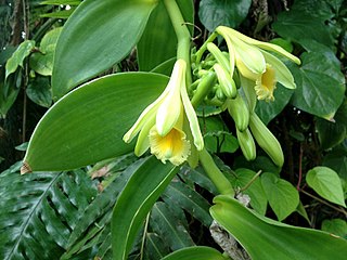
Vanilla is a flavoring derived from orchids of the genus Vanilla, primarily from the Mexican species, flat-leaved vanilla (V. planifolia). The word vanilla, derived from vainilla, the diminutive of the Spanish word vaina, is translated simply as "little pod". Pre-Columbian Mesoamerican people cultivated the vine of the vanilla orchid, called tlīlxochitl by the Aztecs. Spanish conquistador Hernán Cortés is credited with introducing both vanilla and chocolate to Europe in the 1520s.

Coffee Brewed beverage

Coffee is a brewed drink prepared from roasted coffee beans, the seeds of berries from certain Coffea species. The genus Coffea is native to tropical Africa and Madagascar, the Comoros, Mauritius, and Réunion in the Indian Ocean. Coffee plants are now cultivated in over 70 countries, primarily in the equatorial regions of the Americas, Southeast Asia, Indian subcontinent, and Africa. The two most commonly grown are C. arabica and C. robusta. Once ripe, coffee berries are picked, processed, and dried. Dried coffee seeds are roasted to varying degrees, depending on the desired flavor. Roasted beans are ground and then brewed with near-boiling water to produce the beverage known as coffee.

Clove species of plant

Cloves are the aromatic flower buds of a tree in the family Myrtaceae, Syzygium aromaticum. They are native to the Maluku Islands in Indonesia, and are commonly used as a spice. Cloves are commercially harvested primarily in Bangladesh, Indonesia, India, Madagascar, Pakistan, Sri Lanka, and Tanzania (Zanzibar). Cloves are available throughout the year due to different harvest seasons in different countries.

References and notes

  1. 1 2 3 "ILO census data". Cornell University. 2002. Retrieved 2008-02-15.

Coordinates: 14°37′S50°8′E / 14.617°S 50.133°E / -14.617; 50.133

Geographic coordinate system Coordinate system

A geographic coordinate system is a coordinate system that enables every location on Earth to be specified by a set of numbers, letters or symbols. The coordinates are often chosen such that one of the numbers represents a vertical position and two or three of the numbers represent a horizontal position; alternatively, a geographic position may be expressed in a combined three-dimensional Cartesian vector. A common choice of coordinates is latitude, longitude and elevation. To specify a location on a plane requires a map projection.


Related Research Articles

San Justo is a municipality in the province of Zamora, part of the autonomous community of Castile and León, Spain. It had a population of 304 inhabitants in the 2007 census.

Madrigalejo is a municipality located in the province of Cáceres, Extremadura, Spain. According to the 2006 census (INE), the municipality has a population of 2075 inhabitants. In this village, Ferdinand II of Aragon died in 1516.

Marotolana, Ambanja Place in Diana, Madagascar

Marotolana is a municipality in Madagascar. It belongs to the district of Ambanja, which is a part of Diana Region. According to 2001 census the population of Marotolana was 10,538.

Matsohely Place in Sava, Madagascar

Matsohely is a commune in northern Madagascar. It belongs to the district of Andapa, which is a part of Sava Region. According to a 2001 census, the population of Matsohely was 7,565.

Andrakata Place in Sava, Madagascar

Andrakata is a commune in northern Madagascar. It belongs to the district of Andapa, which is a part of Sava Region. According to 2001 census the population of Andrakata was 15,401.

Antsahanoro Place in Sava, Madagascar

Antsahanoro is a commune in northern Madagascar. It belongs to the district of Antalaha, which is a part of Sava Region. According to 2001 census the population of Antsahanoro was 16,253.

Bevonotra Place in Sava, Madagascar

Bevonotra is a town and commune in northern Madagascar. It belongs to the district of Sambava, which is a part of Sava Region. The population of the commune was estimated to be approximately 16,000 in 2001 commune census.

Anjangoveratra Place in Sava, Madagascar

Anjangoveratra is a town and commune in northern Madagascar. It belongs to the district of Sambava, which is a part of Sava Region. The population of the commune was estimated to be approximately 16,000 in 2001 commune census.

Tanambao Daoud Place in Sava, Madagascar

Tanambao Daoud or Tanambao is a town and commune in northern Madagascar. It belongs to the district of Sambava, which is a part of Sava Region. The population of the commune was estimated to be approximately 10,000 in 2001 commune census.

Bekipay Place in Boeny, Madagascar

Bekipay is a town and commune in Madagascar. It belongs to the district of Mitsinjo, which is a part of Boeny Region. The population of the commune was estimated to be approximately 14,000 in 2001 commune census.

Andranovao Place in Melaky, Madagascar

Andranovao is a town and commune in western Madagascar. It belongs to the district of Maintirano, which is a part of Melaky Region. The population of the commune was estimated to be approximately 12,000 in 2001 commune census.

Miarinarivo, Andilamena Place in Alaotra-Mangoro, Madagascar

Miarinarivo is a town and commune in Madagascar. It belongs to the district of Andilamena, which is a part of Alaotra-Mangoro Region. The population of the commune was estimated to be approximately 14,000 in 2001 commune census.

Miary Taheza Place in Atsimo-Andrefana, Madagascar

Miary Taheza is a town and commune in Madagascar. It belongs to the district of Sakaraha, which is a part of Atsimo-Andrefana Region. The population of the commune was estimated to be approximately 10,000 in 2001 commune census.

Inanantona Place in Vakinankaratra, Madagascar

Inanantona or Inanantonana is a town and commune in Madagascar. It belongs to the district of Betafo, which is a part of Vakinankaratra Region. The population of the commune was estimated to be approximately 16,000 in 2001 commune census.

Ianapera Place in Atsimo-Andrefana, Madagascar

Ianapera is a town and commune in Madagascar. It belongs to the district of Benenitra, which is a part of Atsimo-Andrefana Region. The population of the commune was estimated to be approximately 10,000 in 2001 commune census.

Marolinta Place in Androy, Madagascar

Marolinta is a town and commune in Madagascar. It belongs to the district of Beloha, which is a part of Androy Region.

Belemoka Place in Vatovavy-Fitovinany, Madagascar

Belemoka is a town and commune in Madagascar. It belongs to the district of Ikongo, which is a part of Vatovavy-Fitovinany Region. The population of the commune was estimated to be approximately 13,000 in 2001 commune census.

Sahalanona Place in Vatovavy-Fitovinany, Madagascar

Sahalanona is a town and commune in Madagascar. It belongs to the district of Ikongo, which is a part of Vatovavy-Fitovinany Region. The population of the commune was estimated to be approximately 14,000 in 2001 commune census.

Conselheiro Mairinck is a municipality in the state of Paraná in the Southern Region of Brazil.

Prilike Village in Moravica District, Serbia

Prilike is a village in the municipality of Ivanjica, Serbia. According to the 2011 census, the village has a population of 1,311 inhabitants.