Maroambiny | |
|---|---|
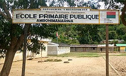 a school in Ambhimanarina Maroambihy | |
 Maroambiny Location in Madagascar | |
| Coordinates: 14°28′S49°46′E / 14.467°S 49.767°E | |
| Country | |
| Region | Sava |
| District | Sambava |
| Elevation | 695 m (2,280 ft) |
| Population (2001) [2] | |
• Total | 11,000 |
| Time zone | UTC3 (EAT) |
Maroambiny or Maroambihy is a town and commune (Malagasy : kaominina) in northern Madagascar. It belongs to the district of Sambava, which is a part of Sava Region. The population of the commune was estimated to be approximately 11,000 in 2001 commune census. [2]
Primary and junior level secondary education are available in town. The majority 93% of the population in the commune are farmers, while an additional 1% receives their livelihood from raising livestock. The most important crop is vanilla, while other important products are coffee, cloves and rice. Industry and services provide employment for 1% and 5% of the population, respectively. [2]
