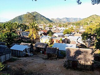
Analamaho

Last updated
Analamaho
Madagascar location map.svg
Red pog.svg
Analamaho
Location in Madagascar
Coordinates: 14°12′S49°57′E / 14.200°S 49.950°E / -14.200; 49.950
CountryFlag of Madagascar.svg  Madagascar
Region Sava
District Sambava
Elevation [1] 112 m (367 ft)
Population (2001) [2]
  Total 6,000
Time zone EAT (UTC3)

Analamaho is a town and commune (Malagasy : kaominina) in northern Madagascar. It belongs to the district of Sambava, which is a part of Sava Region. The population of the commune was estimated to be approximately 6,000 in 2001 commune census. [2]

Malagasy is an Austronesian language and the national language of Madagascar. Most people in Madagascar speak it as a first language as do some people of Malagasy descent elsewhere.

Madagascar island nation off the coast of Southeast Africa, in the Indian Ocean

Madagascar, officially the Republic of Madagascar, and previously known as the Malagasy Republic, is an island country in the Indian Ocean, approximately 400 kilometres off the coast of East Africa. The nation comprises the island of Madagascar and numerous smaller peripheral islands. Following the prehistoric breakup of the supercontinent Gondwana, Madagascar split from the Indian subcontinent around 88 million years ago, allowing native plants and animals to evolve in relative isolation. Consequently, Madagascar is a biodiversity hotspot; over 90% of its wildlife is found nowhere else on Earth. The island's diverse ecosystems and unique wildlife are threatened by the encroachment of the rapidly growing human population and other environmental threats.

Districts of Madagascar

Districts are second-level administrative divisions of Madagascar below the regions. There are 114 districts in Madagascar. Districts are in their turn divided into communes; while some of the districts in urban areas and offshore islands each consist of only one commune, most of the districts are divided typically into 5–20 communes.

Only primary schooling is available in town. The majority 90% of the population in the commune are farmers. The most important crop is vanilla, while other important products are coffee and rice. Services provide employment for 10% of the population. [2]

Vanilla A flavoring extracted from orchids of the genus Vanilla

Vanilla is a flavoring derived from orchids of the genus Vanilla, primarily from the Mexican species, flat-leaved vanilla (V. planifolia). The word vanilla, derived from vainilla, the diminutive of the Spanish word vaina, is translated simply as "little pod". Pre-Columbian Mesoamerican people cultivated the vine of the vanilla orchid, called tlīlxochitl by the Aztecs. Spanish conquistador Hernán Cortés is credited with introducing both vanilla and chocolate to Europe in the 1520s.

Coffee Brewed beverage

Coffee is a brewed drink prepared from roasted coffee beans, the seeds of berries from certain Coffea species. The genus Coffea is native to tropical Africa and Madagascar, the Comoros, Mauritius, and Réunion in the Indian Ocean. Coffee plants are now cultivated in over 70 countries, primarily in the equatorial regions of the Americas, Southeast Asia, Indian subcontinent, and Africa. The two most commonly grown are C. arabica and C. robusta. Once ripe, coffee berries are picked, processed, and dried. Dried coffee seeds are roasted to varying degrees, depending on the desired flavor. Roasted beans are ground and then brewed with near-boiling water to produce the beverage known as coffee.

Rice cereal grain and seed of Oryza sativa

Rice is the seed of the grass species Oryza sativa or Oryza glaberrima. As a cereal grain, it is the most widely consumed staple food for a large part of the world's human population, especially in Asia. It is the agricultural commodity with the third-highest worldwide production, after sugarcane and maize.

References and notes

  1. Estimated based on DEM data from Shuttle Radar Topography Mission
  2. 1 2 3 "ILO census data". Cornell University. 2002. Retrieved 2008-02-23.

Coordinates: 14°12′S49°57′E / 14.200°S 49.950°E / -14.200; 49.950

Geographic coordinate system Coordinate system

A geographic coordinate system is a coordinate system that enables every location on Earth to be specified by a set of numbers, letters or symbols. The coordinates are often chosen such that one of the numbers represents a vertical position and two or three of the numbers represent a horizontal position; alternatively, a geographic position may be expressed in a combined three-dimensional Cartesian vector. A common choice of coordinates is latitude, longitude and elevation. To specify a location on a plane requires a map projection.


Related Research Articles

Andrahanjo Place in Sava, Madagascar

Andrahanjo is a town and commune in northern Madagascar. It belongs to the district of Sambava, which is a part of Sava Region. The population of the commune was estimated to be approximately 8,000 in 2001 commune census.

Ambodivoara Place in Sava, Madagascar

Ambodivoara is a town and commune in northern Madagascar. It belongs to the district of Sambava, which is a part of Sava Region. The population of the commune was estimated to be approximately 10,000 in 2001 commune census.

Antsahambaharo Place in Sava, Madagascar

Antsahambaharo or Antsambaharo is a town and commune in northern Madagascar. It belongs to the district of Sambava, which is a part of Sava Region. The population of the commune was estimated to be approximately 11,000 in 2001 commune census.

Ampondra Place in Sava, Madagascar

Ampondra is a town and commune in northern Madagascar. It belongs to the district of Vohemar, which is a part of Sava Region. The population of the commune was estimated to be approximately 12,000 in 2001 commune census.

Daraina Place in Sava, Madagascar

Daraina is a town and commune in northern Madagascar. It belongs to the district of Vohemar, which is a part of Sava Region. The city is located at the unpaved part of the Route Nationale 5a between Vohemar and Ambilobe.

Tsarabaria Place in Sava, Madagascar

Tsarabaria is a town and commune in northern Madagascar. It belongs to the district of Vohemar, which is a part of Sava Region. The population of the commune was estimated to be approximately 20,000 in 2001 commune census.

Maromokotra Place in Sava, Madagascar

Maromokotra is a town and commune in northern Madagascar. It is situated at the unpaved Route Nationale 5a halfway between Ambilobe and Daraina, near the Saharenana River. It belongs to the district of Vohemar, which is a part of the Sava Region. The population of the commune was estimated to be approximately 4,000 in the 2001 commune census.

Belambo, Vohemar Place in Sava, Madagascar

Belambo is a town and commune in northern Madagascar. It belongs to Vohemar District, which is a part of Sava Region. The population of the commune was estimated to be approximately 6,000 in 2001 commune census.

Antsirabe Afovoany Place in Sofia, Madagascar

Antsirabe Afovoany is a town and commune in Madagascar. It belongs to the district of Mandritsara, which is a part of Sofia Region. The population of the commune was estimated to be approximately 13,000 in 2001 commune census.

Tsaratanana, Mandritsara Place in Sofia, Madagascar

Tsaratanana is a town and commune in Madagascar. It belongs to the district of Mandritsara, which is a part of Sofia Region. The population of the commune was estimated to be approximately 6,000 in 2001 commune census.

Ambatoriha Place in Sofia, Madagascar

Ambatoriha or Ambatoria is a town and commune in Madagascar. It belongs to the district of Bealanana, which is a part of Sofia Region. The population of the commune was estimated to be approximately 9,000 in 2001 commune census.

Antsiatsiaka Place in Analanjirofo, Madagascar

Antsiatsiaka is a town and commune in Madagascar. It belongs to the district of Fenerive Est, which is a part of Analanjirofo Region. The population of the commune was estimated to be approximately 27,000 in 2001 commune census.

Miorimivalana Place in Analanjirofo, Madagascar

Miorimivalana is a town and commune in Madagascar. It belongs to the district of Fenerive Est, which is a part of Analanjirofo Region. The population of the commune was estimated to be approximately 21,000 in 2001 commune census.

Vavatenina Place in Analanjirofo, Madagascar

Vavatenina is a town and commune in Madagascar. It belongs to the district of Vavatenina, which is a part of Analanjirofo Region. The population of the commune was estimated to be approximately 30,000 in 2001 commune census.

Antanandava, Moramanga Place in Alaotra-Mangoro, Madagascar

Antanandava is a town and commune in Madagascar. It belongs to the district of Moramanga, which is a part of Alaotra-Mangoro Region. The population of the commune was estimated to be approximately 9,000 in 2001 commune census.

Vinaninony-Atsimo Place in Vakinankaratra, Madagascar

Vinaninony - Atsimo is a town and commune in Madagascar. It belongs to the district of Faratsiho, which is a part of Vakinankaratra Region. The population of the commune was estimated to be approximately 32,000 in 2001 commune census.

Ambohimandroso, Ambalavao Place in Haute Matsiatra, Madagascar

Ambohimandroso is a town and commune in Madagascar. It belongs to the district of Ambalavao, which is a part of Haute Matsiatra Region. The population of the commune was estimated to be approximately 12,000 in 2001 commune census.

Ampasipotsy, Manakara Place in Vatovavy-Fitovinany, Madagascar

Ampasipotsy is a town and commune in Madagascar. It belongs to the district of Manakara, which is a part of Vatovavy-Fitovinany Region. The population of the commune was estimated to be approximately 6,000 in 2001 commune census.

Ambolomadinika Place in Vatovavy-Fitovinany, Madagascar

Ambolomadinika is a town and commune in Madagascar. It belongs to the district of Ikongo, which is a part of Vatovavy-Fitovinany Region. The population of the commune was estimated to be approximately 13,000 in 2001 commune census.

Amparihy Est Place in Atsimo-Atsinanana, Madagascar

Amparihy Est is a town and commune in Madagascar. It belongs to the district of Vangaindrano, which is a part of Atsimo-Atsinanana Region. The population of the commune was estimated to be approximately 14,000 in 2001 commune census.