Ambohitralanana is a town and commune (Malagasy: kaominina) in northern Madagascar. It belongs to the district of Antalaha, which is a part of Sava Region. In 2001, the population was 17,850.[1]
Ambohitralanana has a riverine harbour and schools for primary and junior high education.
As of 2001, the majority of townspeople (80%) are farmers, but only 0.6% raise livestock. The most important crops are rice and vanilla, followed by cloves and cassava. Industry and service sectors employ 1% and 0.4% of the population, respectively, while fishing employs 18%.[1]
The Arctic Archipelago, also known as the Canadian Arctic Archipelago, is an archipelago lying to the north of the Canadian continental mainland, excluding Greenland and Iceland.
The Java Sea is an extensive shallow sea on the Sunda Shelf, between the Indonesian islands of Borneo to the north, Java to the south, Sumatra to the west, and Sulawesi to the east. Karimata Strait to its northwest links it to the South China Sea. It is a part of the western Pacific Ocean.
Nor Lípez is a province in the Bolivian department of Potosí. Its seat is Colcha "K", also called Villa Martín. The majority of the area of the province was titled as the Nor Lípez Native Community Land on 19 April 2011. One of the largest mines of Bolivia, the San Cristóbal Mine, is located near San Cristóbal in Colcha "K" municipality.
Tomás Barrón is a province in the northern parts of the Bolivian department of Oruro.
Basarabeasca is a district in the south of Moldova, with the administrative center at Basarabeasca.
Marosakoa is a municipality in western Madagascar over the Mozambique Channel. It is approximately 35 kilometres south of Mahajanga. It belongs to the district of Marovoay, which is a part of Boeny Region. The population of the commune was estimated to be approximately 10,000 in 2001 commune census.
Antalaha District is a district in northeastern Madagascar. The district contains the Masoala Peninsula, and is limited by Antongil Bay in south-west and the Indian Ocean on east. It is a part of Sava Region and borders the districts of Sambava into the north, Andapa to the north-west and Maroantsetra to the west. The area is 6,795 km2 (2,624 sq mi) and the population was estimated to be 222,203 in 2009 and 282,921 in 2018. At the time of the last Madagascar census in 1993 149,684 inhabitants lived in this district.
Tsiningia is a town and commune in Madagascar. It belongs to the district of Boriziny, which is a part of Sofia Region. The population of the commune was estimated to be approximately 16,000 in 2001 commune census.
Katsepy is a municipality in Madagascar. It belongs to the district of Mitsinjo, which is a part of Boeny Region. The population of the commune was estimated to be approximately 10,000 in 2001 commune census.
Sarobaratra is a town and commune in Madagascar. It belongs to the district of Tsaratanana, which is a part of Betsiboka Region. The population of the commune was estimated to be approximately 6,000 in 2001 commune census.
Bejofo is a town and commune in Madagascar. It belongs to the district of Ambatondrazaka, which is a part of Alaotra-Mangoro Region. The population of the commune was estimated to be approximately 13,000 in 2001 commune census.
Ambalamahasoa is a town and commune in Madagascar. It belongs to the district of Fianarantsoa II, which is a part of Haute Matsiatra Region. The population of the commune was estimated to be approximately 8,000 in 2001 commune census.
Beteza is a town and commune in Madagascar. It belongs to the district of Bekily, which is a part of Androy Region. The population of the commune was estimated to be approximately 7,000 in 2001 commune census.
Ivahona is a town and commune in Madagascar. It belongs to the district of Betroka, which is a part of Anosy Region. The population of the commune was estimated to be approximately 7,000 in 2001 commune census.
Ambongo is a town and commune in Madagascar. It belongs to the district of Vangaindrano, which is a part of Atsimo-Atsinanana Region. The population of the commune was estimated to be approximately 18,000 in 2001 commune census.
Chã Grande is a city located in the state of Pernambuco, Brazil. It is 80 km away from Recife, the capital of the state of Pernambuco. It has an estimated population of 21,815 inhabitants.
Azurduy Municipality is the first municipal section of Azurduy Province in the Chuquisaca Department of Bolivia. Its seat is Villa Azurduy. In 2012 the population was 10,594 persons. The municipality is very poor; in 2010 93% were below the poverty line, and 75% were in extreme poverty. In 2001 there were seven automobiles in the municipality.
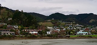
Atawhai is a suburb of Nelson, New Zealand. It lies north of Nelson and is the location of Wakapuaka Cemetery, a burial place since 1861. It also has a coastline on Nelson Haven and access to Boulder Bank from State Highway 6.
This page is based on this Wikipedia article Text is available under the CC BY-SA 4.0 license; additional terms may apply. Images, videos and audio are available under their respective licenses.