
Miranda is a suburb in southern Sydney, in the state of New South Wales, Australia. The suburb is known as a commercial centre for the southern suburbs. Miranda is 24 kilometres south of the Sydney central business district, in the Sutherland Shire.

Birdwood is a town near Adelaide, South Australia. It is located in the local government areas of the Adelaide Hills Council and the Mid Murray Council.

Landsborough is a town and a locality in the Sunshine Coast Region, Queensland, Australia. In the 2016 census, Landsborough had a population of 3,812 people.

Ariah Park is a small town in the Riverina region of New South Wales, Australia, 35 kilometres (22 mi) west of Temora and 65 kilometres (40 mi) south of West Wyalong. The town is within the Temora Shire near Burley Griffin Way. On Census night 2011, Ariah Park had a population of 268 people. The town is listed by the National Trust as a Conservation Area.

Killarney is a rural town and locality in the Southern Downs Region, Queensland, Australia. It borders New South Wales. In the 2016 census, the locality of Killarney had a population of 954 people.

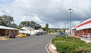
Ardlethan is a small service town in the Coolamon Shire in New South Wales, Australia. Ardlethan is at the intersection of the Burley Griffin Way and Newell Highway.
Proston is a rural town and locality in the South Burnett Region, Queensland, Australia. In the 2016 census, Proston had a population of 379 people.

Bethungra is a locality in Junee Shire in the South West Slopes region of New South Wales, Australia situated on the Olympic Highway about 13 kilometres northeast of Illabo and 24 kilometres southwest of Cootamundra.
Boinka is a locality situated on the section of the Mallee Highway and Pinnaroo railway line between Ouyen and the South Australian border in the Sunraysia region of Victoria, Australia. Boinka is situated approximately 4 kilometres east from Tutye and 8 kilometres west from Linga.

Carina is a locality situated in the Sunraysia region on the Mallee Highway and Pinnaroo railway line. It is situated about 10 kilometres east from Panitya and 14 kilometres west from Murrayville.

Jambin is a rural town and locality in the Shire of Banana, Queensland, Australia.

Kooloonong is a locality in Victoria, Australia, located approximately 147 km from Mildura, Victoria and was on the Yungera railway line.
Mundoo is a rural town and locality in the Cassowary Coast Region, Queensland, Australia. In the 2016 census the locality of Mundoo had a population of 224 people.

Bromelton is a rural locality in the Scenic Rim Region, Queensland, Australia. In the 2016 census, Bromelton had a population of 155 people.

Bonegilla is a bounded rural locality of the City of Wodonga local government area in north-east Victoria, Australia, 10 kilometres (6.2 mi) east of Wodonga, and around 300 kilometres (190 mi) north-east of Melbourne. In the 2016 census, Bonegilla and surrounding area had a population of 693.

Rollingstone is a town and coastal locality in the City of Townsville, Queensland, Australia. As of the 2016 census, the population of Rollingstone was 125.
Barraba is a town in the New England region of northern New South Wales, Australia. It was formerly the centre of Barraba Shire local government area, but most of this, including Barraba, was absorbed into Tamworth Regional Council in 2004. On Census night 2016, Barraba had a population of approximately 1,400 people. It is part of the Bundarra-Barraba Important Bird Area which is important for the conservation of the endangered regent honeyeater.

Maxwelton is a small rural town and locality in the Shire of Richmond in central north Queensland, Australia. At the 2016 Census the population of the state suburb of Maxwelton was 22.

Aubigny is a rural town and locality in the Toowoomba Region, Queensland, Australia. In the 2016 census, Aubigny had a population of 254 people.

