
Markham is a city in York Region, Ontario, Canada. It is approximately 30 km (19 mi) northeast of Downtown Toronto. In the 2021 Census, Markham had a population of 338,503, which ranked it the largest in York Region, fourth largest in the Greater Toronto Area (GTA), and 16th largest in Canada.

Kanata is a suburb and former city within Ottawa, Ontario, Canada. It is located about 22 km (14 mi) west of the city's downtown core. As of 2021, the former City of Kanata had a population of 98,938, with the population centre having a population of 137,118. Before it was amalgamated into Ottawa in 2001, it was one of the fastest-growing cities in Canada and the fastest-growing community in Eastern Ontario. Located just to the west of the National Capital Commission Greenbelt, it is one of the largest of several communities that surround central Ottawa.

The Rouge River is a river in Markham, Pickering, Richmond Hill and Toronto in the Greater Toronto Area of Ontario, Canada. The river flows from the Oak Ridges Moraine to Lake Ontario at the eastern border of Toronto, and is the location of Rouge Park, the only national park in Canada within a municipality. At its southern end, the Rouge River is the boundary between Toronto and southwestern Pickering in the Regional Municipality of Durham.

Scarborough Village is a neighbourhood in Toronto, Ontario, Canada, located in the larger namesake Scarborough district. It was one of the earliest settlements in the former township of Scarborough with the distinction of being the site of the township's first post office. Despite this, it was not the town centre from where the later City of Scarborough grew, with mass urbanization of the former municipality actually having began as spillover growth from the old City of Toronto at Birch Cliff in the district's southwestern extremity. Today, the neighbourhood is composed of private and public housing, apartment complexes, schools, a few condominiums, and strip mall plazas. The neighbourhood lies along the Scarborough Bluffs escarpment.

Barrhaven is a suburb of Ottawa, Ontario, Canada. It is located about 17 km (11 mi) southwest of the city's downtown core. Prior to amalgamation with Ottawa in 2001, Barrhaven was part of the City of Nepean. Its population as of the Canada 2021 Census was 103,234.

Major Mackenzie Drive, often shortened to Major Mac, is a major east-west arterial road in southern York Region, Ontario, Canada, just north of Toronto. It is a York regional road, numbered as York Regional Road 25, and passes through the three cities of southern York Region: Vaughan, Ontario, Richmond Hill, and Markham. It does not continue outside of York Region as an east-west road, but does cross into Brampton as Coleraine Drive which immediately curves sharply at the boundary to head north towards Bolton.

McCowan Road is a major north-south thoroughfare in the Greater Toronto Area, Canada. It runs through the city of Toronto and into the Regional Municipality of York where it ends at the Town of Georgina.

Kennedy Road is a north-south street in Toronto and York Region, Ontario, Canada. It is one of three major streets in Scarborough, and is home to the business district of Scarborough because of the many hundreds of stores along Kennedy Road. The Toronto section of the road is mainly residential with high rise apartment buildings, but there is a large section of commercial activity from Lawrence Avenue East to just north of Sheppard Avenue East. North of Steeles Avenue, it is also known as York Regional Road 3, and traverses Markham, Whitchurch-Stouffville, East Gwillimbury, and Georgina, where it terminates at Lake Drive East.

Buttonville is a suburban neighbourhood and former hamlet in the city of Markham, Ontario, Canada, bordering the larger Unionville district. The hamlet was named after its founder, John Button.

Unionville is a suburban district and former village in Markham, Ontario, Canada, 2 km (2.5 mi) northeast of Downtown Markham, 2 km (2.5 mi) west of Markham Village, and 33 km (20.5 mi) northeast of Downtown Toronto, centred around the intersection of Highway 7 and Kennedy Road. The boundaries of Unionville are not well-defined. Several nearby neighbourhoods are claimed to be part of it however, this has been disputed between the various wards. The Unionville Ratepayers Association designates Rodick Road as its western boundary.

The history of Markham, Ontario dates back several millennia. What would become Markham, Ontario was home to First Nations long before European settlement. Seasonal settlements were found from 900 BC to 1650, but traces of these first residence were buried before the area was farmed.
Cachet is a neighbourhood within northwestern Markham, Ontario, Canada. It is bounded by 16th Avenue to the south, Major Mackenzie Drive East to the north, Warden Avenue to the east and Woodbine Avenue or Highway 404, to the west.

Milliken and Milliken Mills are neighbourhoods in the cities of Toronto and Markham. Milliken is situated in the north west section of Scarborough, whereas Milliken Mills is situated in the south-central portions of Markham. The neighbourhoods are centered on Kennedy Road and Steeles Avenue, the latter street serving as the boundary between the cities of Markham and Toronto.
Quantztown is an unincorporated community located in the city of Markham, Ontario, Canada, near McCowan Road and 16th Avenue. It is named for German settler Melchior Quantz (1749-1827), who arrived in 1794 along with William Berczy and other settlers.

Berczy Village is a residential neighbourhood in Markham, Ontario, Canada. It is bounded to the north by Major Mackenzie Drive, to the east by McCowan Road, to the south by 16th Avenue, and to the west by Kennedy Road. This area is north of Unionville. The community is named after William Berczy, Markham's founder. The name is shown on limestone plaques throughout the community's arterial road entrances.

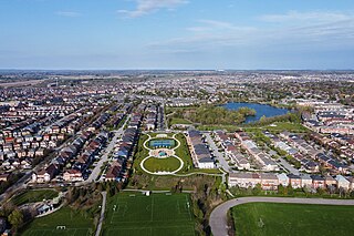
Downtown Markham is the main downtown of Markham, Ontario, Canada. Currently under development, it is located near the historic Unionville district and serves as the new heart of Markham. Businesses in the district are expected to employ up to 16,000 individuals, and it may house as many as 10,000 residents. The development plans will have a high density of residential, retail, commercial and mixed-use structures. The community is being developed, built and wholly financed by The Remington Group Inc.
Greensborough(Census Tract Number 5350403.03) is a community in the city of Markham in the Regional Municipality of York in the Canadian province of Ontario.

Raymerville - Markville East(Census Tract No. 5350400.03 and 5350400.12) is a community in Markham, Ontario, Canada. The name "Raymerville" came from the community's major collector road, Raymerville Drive. The name "Markville" came from the local major shopping mall, Markville Shopping Centre. The community is referred to as "Markville East" because it is located immediately east of Markville Shopping Centre.

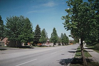
Markham Village is the historic town centre of Markham, Ontario, Canada. Originally settled in 1825, the village, which was originally named Reesorville sometime after 1804 and also known as Mannheim, was founded by Mennonites from Upstate New York and Pennsylvania. Eventually, as Upper Canada started to experience immigration from the British Isles, Markham would experience significant growth. By 1825, the name "Markham" was established as the permanent name. In 1850, it was established as a police village, and in 1873 was fully incorporated as a village within York County. Markham was amalgamated with the surrounding Markham Township, which included the villages of Unionville and Thornhill in 1971, and incorporated as a town.


