Arimo, Idaho

Last updated

Arimo, Idaho
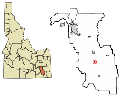
Bannock County Idaho Incorporated and Unincorporated areas Arimo Highlighted 1603340.svg
Location of Arimo in Bannock County, Idaho.
Coordinates: 42°33′34″N112°10′17″W / 42.55944°N 112.17139°W / 42.55944; -112.17139
Country United States
State Idaho
County Bannock
Government
  MayorLonnie Gunter
Area
[1]
  Total0.41 sq mi (1.07 km2)
  Land0.41 sq mi (1.07 km2)
  Water0.00 sq mi (0.00 km2)
Elevation
4,744 ft (1,446 m)
Population
 (2020) [2]
  Total354
  Estimate 
(2019) [3]
364
  Density863.4/sq mi (339.31/km2)
Time zone UTC-7 (Mountain (MST))
  Summer (DST) UTC-6 (MDT)
ZIP code
83214
Area codes 208, 986
FIPS code 16-03340
GNIS feature ID2409729

Arimo is a city in the Marsh Valley in central Bannock County, Idaho, United States, [4] that is part of the 'Pocatello Metropolitan Statistical Area'. The population was 354 at the 2020 census.

Contents

Geography

Arimo is located at 42°33′34″N112°10′17″W / 42.55944°N 112.17139°W / 42.55944; -112.17139 (42.559460, -112.171399). [5]

According to the United States Census Bureau, the city has a total area of 0.44 square miles (1.14 km2), all of it land. [6]

Demographics

Historical population
CensusPop.Note
1930 290
1940 2910.3%
1950 33715.8%
1960 303−10.1%
1970 252−16.8%
1980 33834.1%
1990 311−8.0%
2000 34811.9%
2010 3552.0%
2019 (est.)364 [3] 2.5%
U.S. Decennial Census [7]

2010 census

As of the census [2] of 2010, there were 355 people, 108 households, and 89 families living in the city. The population density was 806.8 inhabitants per square mile (311.5/km2). There were 121 housing units at an average density of 275.0 per square mile (106.2/km2). The racial makeup of the city was 91.3% White, 0.3% Asian, 1.7% Pacific Islander, 2.0% from other races, and 4.8% from two or more races. Hispanic or Latino of any race were 3.1% of the population.

There were 108 households, of which 44.4% had children under the age of 18 living with them, 74.1% were married couples living together, 5.6% had a female householder with no husband present, 2.8% had a male householder with no wife present, and 17.6% were non-families. 13.9% of all households were made up of individuals, and 7.5% had someone living alone who was 65 years of age or older. The average household size was 3.29 and the average family size was 3.67.

The median age in the city was 28.9 years. 35.8% of residents were under the age of 18; 10.4% were between the ages of 18 and 24; 17.5% were from 25 to 44; 25.3% were from 45 to 64; and 11% were 65 years of age or older. The gender makeup of the city was 50.1% male and 49.9% female.

2000 census

As of the census [8] of 2000, there were 348 people, 108 households, and 78 families living in the city. The population density was 854.1 inhabitants per square mile (329.8/km2). There were 118 housing units at an average density of 289.6 per square mile (111.8/km2). The racial makeup of the city was 96.55% White, 0.57% Asian, 0.29% from other races, and 2.59% from two or more races. Hispanic or Latino of any race were 1.44% of the population.

There were 108 households, out of which 46.3% had children under the age of 18 living with them, 65.7% were married couples living together, 5.6% had a female householder with no husband present, and 26.9% were non-families. 25.0% of all households were made up of individuals, and 17.6% had someone living alone who was 65 years of age or older. The average household size was 3.22 and the average family size was 4.00.

In the city, the population was spread out, with 39.4% under the age of 18, 8.3% from 18 to 24, 21.8% from 25 to 44, 17.0% from 45 to 64, and 13.5% who were 65 years of age or older. The median age was 28 years. For every 100 females, there were 93.3 males. For every 100 females age 18 and over, there were 102.9 males.

The median income for a household in the city was $33,500, and the median income for a family was $41,944. Males had a median income of $31,406 versus $19,688 for females. The per capita income for the city was $10,312. About 7.9% of families and 12.6% of the population were below the poverty line, including 16.0% of those under age 18 and 6.3% of those age 65 or over.
Education

Downey is part of the March Valley School Joint District#21 and is served by three schools:

Transportation

Downey is served by one Interstate Highway and one U.S. Highway:

See also

Related Research Articles

<span class="mw-page-title-main">Bannock County, Idaho</span> County in Idaho, United States

Bannock County is a county in the southeastern part of Idaho. As of the 2020 Census, the population was 87,018, making it the sixth-most populous county in Idaho. The county seat and largest city is Pocatello. The county was established in 1893 and named after the local Bannock tribe. It is one of the counties with territories included in the Fort Hall Indian Reservation of the federally recognized Shoshone-Bannock Tribes.

<span class="mw-page-title-main">Honalo, Hawaii</span> Census-designated place in Hawaii, U.S.

Honalo is a census-designated place (CDP) in Hawaiʻi County, Hawaiʻi, United States. The population was 2,423 at the 2010 census, up from 1,987 at the 2000 census.

<span class="mw-page-title-main">Downey, Idaho</span> City in Bannock County, Idaho, United States

Downey is a city in the Marsh Valley in southern Bannock County, Idaho, United States. It is part of the Pocatello Metropolitan Statistical Area. The population was 625 at the 2010 census.

<span class="mw-page-title-main">Basalt, Idaho</span> City in Idaho, United States

Basalt is a city in Bingham County, Idaho, United States. The population was 394 at the 2010 census.

<span class="mw-page-title-main">Greeley, Iowa</span> City in Iowa, United States

Greeley is a city in Delaware County, Iowa, United States. The population was 217 at the time of the 2020 census.

<span class="mw-page-title-main">Little Sioux, Iowa</span> City in Iowa, United States

Little Sioux is a city in Harrison County, Iowa, United States. The population was 166 at the time of the 2020 census. The city is most known for Little Sioux Scout Ranch of the Boy Scouts of America.

<span class="mw-page-title-main">Ollie, Iowa</span> City in Iowa, United States

Ollie is a city in Keokuk County, Iowa, United States. The population was 201 at the time of the 2020 census. Originally known as Hemingford, the town voted to change the name to Ollie in 1892.

<span class="mw-page-title-main">Delphos, Iowa</span> City in Iowa, United States

Delphos is a city in Ringgold County, Iowa, United States. The population was 26 at the 2020 census.

<span class="mw-page-title-main">Columbus, Kansas</span> City in Cherokee County, Kansas

Columbus is the second largest city and county seat of Cherokee County, Kansas, United States. As of the 2020 census, the population of the city was 2,929. It is located approximately 15 miles south-southwest of Pittsburg.

Preston Township is a township in Fillmore County, Minnesota, United States. The population was 374 at the 2000 census.

<span class="mw-page-title-main">Eitzen, Minnesota</span> City in Minnesota, United States

Eitzen is a city in Houston County, Minnesota, United States. The population was 243 at the 2010 census.

<span class="mw-page-title-main">Ceylon, Minnesota</span> City in Minnesota, United States

Ceylon is a city in Martin County, Minnesota, United States. The population was 369 at the 2010 census.

<span class="mw-page-title-main">Climax, Minnesota</span> City in Minnesota, United States

Climax is a city in Polk County, Minnesota, United States. It is part of the Grand Forks, ND-MN Metropolitan Statistical Area. The population was 243 at the 2020 census.

<span class="mw-page-title-main">Cedar Rapids, Nebraska</span> Village in Nebraska, United States

Cedar Rapids is a village in Boone County, Nebraska, United States. The population was 382 at the 2010 census.

Scio is a town in Allegany County, New York, United States. The population was 1,625 at the 2020 census. The town is in the southern half of the county and north of the village of Wellsville.

<span class="mw-page-title-main">Everetts, North Carolina</span> Town in North Carolina, United States

Everetts is a town in Martin County, North Carolina, United States. The population was 164 at the 2010 census.

<span class="mw-page-title-main">Oxbow, North Dakota</span> City in North Dakota, United States

Oxbow is a city in Cass County, North Dakota, United States. The population was 381 at the 2020 census. It is an upscale bedroom community located 15 miles (24 km) south of Fargo. It was incorporated as a city October 25, 1988.

Rocky Ford is a census-designated place (CDP) in Delaware and Cherokee counties, Oklahoma, United States. The population was 61 at the 2010 census.

<span class="mw-page-title-main">Hickory, Oklahoma</span> Town in Oklahoma, United States

Hickory is a town in Murray County, Oklahoma, United States. The population was 87 at the 2000 census.

<span class="mw-page-title-main">Pike Township, Bradford County, Pennsylvania</span> Township in Pennsylvania, United States

Pike Township is a township in Bradford County, Pennsylvania, United States. It is part of Northeastern Pennsylvania. The population was 671 at the 2010 census.

References

  1. "2019 U.S. Gazetteer Files". United States Census Bureau. Retrieved July 9, 2020.
  2. 1 2 "U.S. Census website". United States Census Bureau . Retrieved December 18, 2012.
  3. 1 2 "Population and Housing Unit Estimates". United States Census Bureau. May 24, 2020. Retrieved May 27, 2020.
  4. U.S. Geological Survey Geographic Names Information System: Arimo
  5. "US Gazetteer files: 2010, 2000, and 1990". United States Census Bureau. February 12, 2011. Retrieved April 23, 2011.
  6. "US Gazetteer files 2010". United States Census Bureau. Archived from the original on January 25, 2012. Retrieved December 18, 2012.
  7. "Census of Population and Housing". Census.gov. Retrieved June 4, 2015.
  8. "U.S. Census website". United States Census Bureau . Retrieved January 31, 2008.

Commons-logo.svg Media related to Arimo, Idaho at Wikimedia Commons