
Inyo County is a county in the eastern central part of the U.S. state of California, located between the Sierra Nevada mountains and the state of Nevada. In the 2020 census, the population was 19,016. The county seat is Independence. Inyo County is on the east side of the Sierra Nevada and southeast of Yosemite National Park in Central California. It contains the Owens River Valley; it is flanked to the west by the Sierra Nevada and to the east by the White Mountains and the Inyo Mountains. With an area of 10,192 square miles (26,397 km2), Inyo County is the second-largest county by area in California, after San Bernardino County. Almost one-half of that area is within Death Valley National Park. However, with a population density of 1.8 people per square mile, it also has the second-lowest population density in California, after Alpine County.
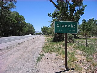
Olancha is a census designated place in Inyo County of the U.S. state of California. Olancha is located on U.S. Route 395 in California, 37 miles (60 km) south-southeast of Independence, at an elevation of 3658 feet. As of the 2010 census, the population was 192, up from 134 at the 2000 census.

Mill Valley is a city in Marin County, California, United States, located about 14 miles (23 km) north of San Francisco via the Golden Gate Bridge and 52 miles (84 km) from Napa Valley. The population was 14,231 at the 2020 census.

Skidoo was an unincorporated community in Inyo County, California. The geographical location of the old town site lies at an elevation of 5,689 feet. Skidoo is a ghost town located in Death Valley National Park. It is on the National Register of Historic Places.

Badwater is a locale in Inyo County, California. It is located in Death Valley 7 miles (11 km) northeast of Bennetts Well, at an elevation of −266 feet (−81 m).

Gualala is an unincorporated community in Mendocino County in the U.S. state of California. It is located north of The Sea Ranch and south of Point Arena, California. Gualala shares its southern border with the southern border of Mendocino County. It is located on the Pacific coast at the mouth of the Gualala River, on State Route 1. It serves as a commercial center for the surrounding area. Gualala was once a logging town, but tourism is now its central economic activity.

Panamint City is a ghost town in the Panamint Range, near Death Valley, in Inyo County, California, US. It is also known by the official Board of Geographic Names as Panamint. Panamint was a boom town founded after silver and copper were found there in 1872. By 1874, the town had a population of about 2,000. Its main street was one mile (1.6 km) long. Panamint had its own newspaper, the Panamint News. Silver was the principal product mined in the area. The town is located about three miles northwest of Sentinel Peak. According to the National Geographic Names Database, NAD27 latitude and longitude for the locale are 36°07′06″N117°05′43″W, and the feature ID number is 1661185. The elevation of this location is identified as being 6,280 feet AMSL. The similar-sounding Panamint Springs, California, is located about 25.8 miles at 306.4 degrees off true north near Panamint Junction.
Branscomb is an unincorporated community in Mendocino County in the U.S. state California. It is located 8 miles (13 km) west-southwest of Laytonville, at an elevation of 1565 feet, on a river terrace to the east of the South Fork Eel River.
Chloride City is a ghost town in Inyo County, California, United States. It is located 8.5 miles (14 km) north-northeast of Beatty Junction, at an elevation of 4,770 ft (1,450 m). The former settlement is now in Death Valley National Park.

Arroyo Corte Madera del Presidio is a 4.1-mile-long (6.6 km) year-round stream in southern Marin County, California, United States. This watercourse is also known as Corte Madera Creek, although the actual stream of that name flows into San Francisco Bay further north at Point San Quentin. This watercourse has a catchment basin of about 8 square miles (21 km2) and drains the south-eastern slopes of Mount Tamalpais and much of the area in and around the town of Mill Valley; this stream discharges to Richardson Bay.
Caldor was a company town in El Dorado County, California. Caldor was linked to Diamond Springs by the Diamond and Caldor Railway. The community was named for the California Door Company, which owned and operated the town.
Crater was an unincorporated community in Inyo County, California. It is located in the Last Chance Range 19 miles (31 km) northwest of Ubehebe Crater, at an elevation of 5305 feet.
Reilly is a former settlement in Inyo County, California. It was located on the west side of the Panamint Valley, at an elevation of 2582 feet. Reilly was a silver mining community in the late 19th century.
Gypsite was a small community at the site of a mill in Kern County, California.

Burnt Wagons is a former settlement in Inyo County, California, near Stovepipe Wells. It was located in Death Valley 7 miles (11 km) northwest of Death Valley Junction. The name recalls the emigrants of 1849 who abandoned and burnt their wagons at the site. The site is now registered as California Historical Landmark #441. The monument's plaque reads:
BURNED WAGONS POINT Near this monument, the Jayhawker group of Death Valley Forty-Niners, gold seekers from Middle West, who entered Death Valley in 1849 seeking short route to the mines of central California, burned their wagons, dried the meat of some oxen and, with surviving animals, struggled westward on foot.
STATE REGISTERED LANDMARK NO.441
Marker placed by California Centennials Commission.
Base furnished by Death Valley '49ers, Inc.
Dedicated December 3rd, 1949
Boston Ravine is a former settlement in Nevada County, California. Boston Ravine is located 1 mile (1.6 km) south-southwest of Grass Valley. Its elevation is 2,339 ft (713 m) above sea level.
Union Hill is a former settlement in Nevada County, California, 1.5 mi (2.4 km) from Grass Valley. Its elevation is 2,700 ft (820 m) above sea level.
Navarro is an unincorporated community in Mendocino County in the U.S. state of California. It is located 18 miles (29 km) west of Ukiah, at an elevation of 269 feet (82 m). It may be reached via the east–west California State Route 128, which connects it to the Pacific coast to the west and to the Anderson Valley to the southeast.

Bonnie Claire is a ghost town located in Nye County, Nevada. The settlement is located on the edge of Sarcobatus Flat adjacent to Nevada State Route 267. The mines of Slate Ridge lie to the northwest and the northernmost spur of the Amargosa Range, the Grapevine Mountains, is just to the south of the townsite. Bonnie Claire Flat extends to the southwest between the Slate Ridge and the Grapevines to the California border.
Round Valley is a former settlement in Plumas County, California, at an elevation of 4521 feet. Round Valley is located northwest of the Round Valley Reservoir, 3 miles (4.8 km) south of Greenville, and 3.5 miles (5.6 km) west-northwest of Crescent Mills.


