
Shipton Lee is a hamlet and former civil parish, now in the parish of Quainton, in the county of Buckinghamshire, England. In 1881 the parish had a population of 61. From 1866 to 1886 Shipton Lee was a civil parish in its own right. On 25 March 1886 the parish was abolished and merged with Quainton.

Teeton is a village and former civil parish, now in the parish of Hollowell, in the West Northamptonshire district, in the ceremonial county of Northamptonshire, England. In 1931 the parish had a population of 55. In 1866 Teeton became a civil parish, on 1 April 1935 the parish was abolished and merged with Hollowell.
Hanging Houghton is a small village and former civil parish, now in the parish of Lamport, in the West Northamptonshire district, in the ceremonial county of Northamptonshire, England. It is on the A508 road between Brixworth and Lamport. In 1931 the parish had a population of 84.

Stanground is a residential area of Peterborough, in the ceremonial county of Cambridgeshire, England. For electoral purposes, it comprises the Stanground South and Fletton & Stanground wards in the North West Cambridgeshire constituency.

A civil parish is a country subdivision, forming the lowest unit of local government in England. There are 264 civil parishes in the ceremonial county of Cambridgeshire, most of the county being parished; Cambridge is completely unparished; Fenland, East Cambridgeshire, South Cambridgeshire and Huntingdonshire are entirely parished. At the 2001 census, there were 497,820 people living in the parishes, accounting for 70.2 per cent of the county's population.

Westwick is a hamlet and former civil parish, now in the parish of Oakington and Westwick, in the South Cambridgeshire district, in the county of Cambridgeshire, England. It is situated to the north-west of Cambridge. Earthworks suggest that it is a shrunken medieval village. In 1961 the parish had a population of 37.

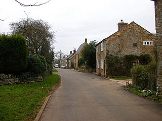
Alstone is a village and former civil parish, now in the parish of Teddington, in the Tewkesbury district, in the county of Gloucestershire, England, situated between the towns of Tewkesbury and Winchcombe. In 1931 the parish had a population of 50.

Bainton is a village and civil parish in the Peterborough unitary authority area of Cambridgeshire, England. Bainton is on the southern edge of the Welland valley and lies 7.4 miles (11.9 km) north-west of Peterborough and 4 miles (6.4 km) east of Stamford. Ashton is a neighbouring hamlet and lies approximately 1 mile (1.6 km) south-east of Bainton within the same civil parish. At the time of the 2001 census, the parish's population was 305 people and by the 2011 census the parish's population was 290 people.

Coton is a hamlet and former civil parish, now in the parish of Ravensthorpe, in the West Northamptonshire district, in the ceremonial county of Northamptonshire, England. It is located between Guilsborough and Ravensthorpe. Coton Manor is a popular visitor attraction for its gardens and bluebell woods. In 1931 the parish had a population of 83.
Gunthorpe is a residential area of the city of Peterborough, in the ceremonial county of Cambridgeshire, England. Since 2015 Gunthorpe has its own ward within Peterborough City Council that also encompasses parts of South Werrington.

Woodston is a largely residential and industrial area of the city of Peterborough, in the ceremonial county of Cambridgeshire, England. For electoral purposes, it forms part of Fletton ward in North West Cambridgeshire constituency. Oundle Road runs through most of Woodston into the Ortons.

Armston is a hamlet and former civil parish, now in the parish of Polebrook, in the North Northamptonshire district, in the ceremonial county of Northamptonshire, England. In 1931 the parish had a population of 22.

Atterton is a hamlet and former civil parish, now in the parish of Witherley, in the Hinckley and Bosworth district, in the county of Leicestershire, England. It has a population of approximately 40 people. In 1931 the parish had a population of 43.
Aunby is a village in the civil parish of Careby Aunby and Holywell, in the South Kesteven district of Lincolnshire, England. It is situated north from Stamford on the B1176 road, and just south of Careby. In 1921 the parish had a population of 42. Aunby was formerly in the parish of Castle Bytham, in 1866 Aunby became a separate civil parish, on 1 April 1931 the parish was abolished to form "Careby, Aunby and Holywell".

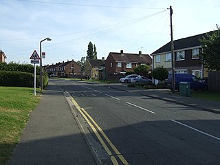
Walton is a residential area and electoral ward of the city of Peterborough in the ceremonial county of Cambridgeshire, England. Manufacturers of industrial machinery, Peter Brotherhood, relocated here from London in 1906.

Woodthorpe is a hamlet just south of Loughborough and former civil parish in the Charnwood district, in Leicestershire, England. In 1931 the parish had a population of 53.

Denton is a hamlet and former civil parish, now in the parish of Cuddesdon and Denton, in the South Oxfordshire district, in Oxfordshire, England. Denton's toponym is derived from the Old English den-tun meaning "valley farmstead". Denton is in a fold of the landscape, between the two hills on which Cuddesdon and Garsington stand. Denton is an ancient manor and had its own civil parish, but it was merged with neighbouring Cuddesdon in the 20th century.
Pilsgate is a hamlet and former civil parish, now in the parish of Barnack, in the Peterborough district, in the ceremonial county of Cambridgeshire, England. Pilsgate is close to the county boundary and 3 miles (5 km) south-east of Stamford, Lincolnshire. In 1881 the parish had a population of 125.

Manthorpe is a village in the civil parish of Toft with Lound and Manthorpe, in the South Kesteven district of Lincolnshire, England. It lies 0.5 miles (0.8 km) east from the A6121, 3 miles (5 km) south-west from Bourne and 6 miles (10 km) north-east from Stamford. Manthorpe was formerly in the parish of Witham on-the-Hill, in 1866 Manthorpe became a separate civil parish, on 1 April 1931 the parish was abolished to form "Toft with Lound and Manthorpe". In 1921 the parish had a population of 74.

Oldbury is a hamlet and former civil parish about 2 miles from Atherstone, now in the parish of Hartshill, in the North Warwickshire district, in the county of Warwickshire, England. In 1961 the parish had a population of 82.

