The name Astley derives from the Old Englishēastlēah meaning 'east wood/clearing'.[3]
There is evidence in the village of Norman heritage. The house Astley Towne has a Norman cellar.
Near St Peter's Church are the remains of a priory built in 1088. The priory was founded by Ralph de Todeni who was given the manor of Eastlie (Astley) following the Norman conquest of England. It was an alien Benedictine House, belonging to a parent monastery in Normandy. The prior's well remains, but is overgrown. To the East of the priory, well-defined earthworks of a medieval village have been found.[4]
St Peter's church is of possible c12 century origins[8] although its origins may have been based on an existing priory.[9]
There are several memorials within the church to the Winford family.[8]
Education
Astley Primary School is a small, rural CoEVoluntary Aided school with about eighty pupils between 4 and 11 years old. A free school was first established in Astley in 1729, endowed by the will of Mercy Pope. The present school was built in 1893.[10]
Although the school is isolated, it is popular with children travelling some distance each day. On leaving Astley school the 11 to 16s go on to The Chantry School at Martley.[11]
Facilities
Astley Burf contains an Outdoor Education centre, owned by Dudley Council, and used by Dudley schools during the spring and summer
Glasshampton was a separate manor from Astley, but like Astley, was in the lower division of Doddingtree Hundred.[5]
The manor of Glasshampton and its associated estate was held by the Winford family.
The house was said to contain 365 windows but was burnt down in 1917. The stable block survived and was converted in 1918 to accommodate a monastery for the Anglican Franciscan order.[12]
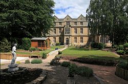
Former Prime Minister, Stanley Baldwin lived at Astley Hall in his later years. His home has now become a nursing home. There is also a monument dedicated to him on the main road between Holt and Stourport. After Baldwin's death, a national appeal failed to raise sufficient money for this memorial. Winston Churchill personally made up the shortfall and attended the dedication of the memorial.[4]
This page is based on this Wikipedia article Text is available under the CC BY-SA 4.0 license; additional terms may apply. Images, videos and audio are available under their respective licenses.