
The M1 motorway connects London to Leeds, where it joins the A1(M) near Aberford, to connect to Newcastle. It was the first inter-urban motorway to be completed in the UK; the first motorway in the country was the Preston Bypass, which later became part of the M6.

The M4, originally the London-South Wales Motorway, is a motorway in the United Kingdom running from west London to southwest Wales. The English section to the Severn Bridge was constructed between 1961 and 1971; the Welsh element was largely complete by 1980, though a non-motorway section around Briton Ferry bridge remained until 1993. On the opening of the Second Severn Crossing in 1996, the M4 was rerouted over it.

The M40 motorway links London, Oxford, and Birmingham in England, a distance of approximately 89 miles (143 km).

The M3 is a motorway in England, from Sunbury-on-Thames, Surrey, to Eastleigh, Hampshire; a distance of approximately 59 miles (95 km). The route includes the Aldershot Urban Area, Basingstoke, Winchester, and Southampton.

The A34 is a major road in England. It runs from the A33 and M3 at Winchester in Hampshire, to the A6 and A6042 in Salford, close to Manchester City Centre. It forms a large part of the major trunk route from Southampton, via Oxford, to Birmingham, The Potteries and Manchester. For most of its length, it forms part of the former Winchester–Preston Trunk Road. Improvements to the section of road forming the Newbury Bypass around Newbury were the scene of significant direct action environmental protests in the 1990s. It is 151 miles (243 km) long.

The M27 is a motorway in Hampshire, England. It is 27.9 miles (44.9 km) long and runs between Cadnam and Portsmouth. It was opened in stages between 1975 and 1983, providing the largest two urban areas in Hampshire with a direct motorway link. An extension into the county of West Sussex was planned but never constructed. A number of smaller motorways were proposed, connecting the city centres of Southampton and Portsmouth to the motorway; of these only the M271 and M275 were built. Three sections of the M27 have since been widened to four lanes each way, the first between junctions 7 and 8, the second between junctions 3 and 4, and the third begins at the slip road where junction 11 joins until mid-way to junction 12.

A dual carriageway (BrE) or a divided highway (AmE) is a class of highway with carriageways for traffic travelling in opposite directions separated by a central reservation (BrE) or median (AmE). Roads with two or more carriageways which are designed to higher standards with controlled access are generally classed as motorways, freeways, etc., rather than dual carriageways.
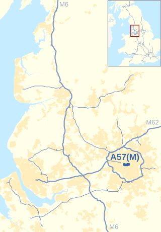
The Mancunian Way is a two mile long grade separated elevated motorway in Manchester, England. It is officially made up of the A57(M) and A635(M) motorways, although the latter does not appear on road signs for practical reasons. It is also part of two other roads: the A57 to the west, which runs east–west through Greater Manchester linking the M602 and M67 motorways, and a short section of non-motorway A635 to the east. Part of this non-motorway section collapsed on 14 August 2015 due to a sinkhole.

The A500 is a major primary A road in Staffordshire and Cheshire, England. It is dual carriageway for most of its length and connects Nantwich, junctions 16 and 15 of the M6 motorway with the city of Stoke-on-Trent. It is 19 miles (31 km) long.

A limited-access road, known by various terms worldwide, including limited-access highway, dual-carriageway, expressway, and partial controlled-access highway, is a highway or arterial road for high-speed traffic which has many or most characteristics of a controlled-access highway, including limited or no access to adjacent property, some degree of separation of opposing traffic flow, use of grade separated interchanges to some extent, prohibition of slow modes of transport, such as bicycles, (draught) horses, or self-propelled agricultural machines; and very few or no intersecting cross-streets or level crossings. The degree of isolation from local traffic allowed varies between countries and regions. The precise definition of these terms varies by jurisdiction.

The Autostrade are roads forming the Italian national system of motorways. The total length of the system is about 7,016 kilometres (4,360 mi), as of 30 July 2022. In North and Central Italy, the Autostrade mainly consists of tollways managed by Autostrade per l'Italia, a holding company controlled by Cassa Depositi e Prestiti. Other operators include ASTM, ATP, and Autostrade Lombarde in the north-west; Autostrada del Brennero, A4 Holding, Concessioni Autostradali Venete, and Autovie Venete in the north-east; Strada dei Parchi, SALT, SAT, and Autocisa in the center; and CAS in the south.

A controlled-access highway is a type of highway that has been designed for high-speed vehicular traffic, with all traffic flow—ingress and egress—regulated. Common English terms are freeway, motorway and expressway. Other similar terms include throughway and parkway. Some of these may be limited-access highways, although this term can also refer to a class of highways with somewhat less isolation from other traffic.

The Moscow Automobile Ring Road, or MKAD (МКАД), is a ring road running predominantly on the city border of Moscow with a length of 108.9 km (67.7 mi) and 35 exits. It was completed in 1962. The speed limit is 100 km/h.

The GRA or Grande Raccordo Anulare is a toll-free, ring-shaped 68.2 kilometres (42.4 mi) long orbital motorway that encircles Rome. GRA is one of the most important roads in Rome, and traffic reaches 160,000 vehicles per day as of 2011.

The A538 is a road in England linking Macclesfield, Cheshire to Altrincham in Greater Manchester, through Prestbury, Wilmslow and Hale and providing access to Manchester Airport and the M56 motorway. The road is a Primary route between the A34 Junction in Wilmslow and Manchester Airport / M56 motorway.

The Autostrada A91, also called Autostrada Roma-Fiumicino, is an Italian motorway which connects Rome to the Fiumicino Airport.

In Ireland, the highest category of road is a motorway, indicated by the prefix M followed by a one- or two-digit number. The motorway network consists entirely of motorway-grade dual carriageways and is largely focused upon Dublin. There are also several three-lane motorways, while Ireland's busiest road, the M50, incorporates four-lane, five-lane, and six-lane stretches.

The Raccordo autostradale 2, or Raccordo autostradale di Avellino, literally "Motorway connection to Avellino", is an Italian motorway that connects the city of Avellino with the motorways A2 and A30 at the Fisciano junction.
It is a part of the European route E841.

Raccordo autostradale 14 , also referred to as RA-Diramazione per Fernetti, is a motorway which connects the Raccordo autostradale RA13 near Opicina with the border of Fernetti. At the border, the junction engages seamlessly with the Slovenian A3 motorway, which passes close to Sesana and engages, at Divaccia, with the Slovenian A1 Motorway, which ends in Ljubljana.

Raccordo autostradale 10 is a motorway that connects the city of Turin with its international airport located in Caselle Torinese 11 km north of the capital of Piedmont.


