Autostrada A6 (Italy)

Last updated
Autostrada A6 Italia.svg
Autostrada A6
La Verdemare
Italia - mappa autostrada A6.svg
Route information
Maintained by ANAS
Length124.3 km (77.2 mi)
Existed1960–present
Major junctions
From Turin
To Savona
Location
Country Italy
Regions Piedmont, Liguria
Highway system

The Autostrada A6 is an Italian motorway opened in 1960 which connects Turin, the southernmost area of Piedmont, especially the Cuneo province, to the west coast of Liguria and the city of Savona. Its construction finished in 2001, when it was completely overhauled into a two-road motorway

Contents

History

Construction

The motorway was built in stages starting in 1956. It began with the Savona – Ceva stretch being inaugurated on 27 January 1960. Work began shortly after in 1961 on the Ceva – Fossano stretch, including a connection to the city of Fossano and to the SS 28 for Turin. In May 1970, the Moncalieri – La Rotta section opened, followed by the Marene – Fossano stretch in July of the same year. Finally, in 1972, the initial Turin – Moncalieri – La Rotta section was built, with a separate roadway to Carmagnola.

The Fiat track

In 1972, a second roadway was put into operation in direction to Savona. This roadway was located in the stretch between Carmagnola and the Rio Coloré West service area. This roadway was used exclusively by FIAT as a test track for higher speeds. The track began three kilometers (approximately 1.86 miles) from the Carmagnola junction, with the terminal square being just before the service area. There is also a square that was used as a technical track at overpass number 33, just 25.400 km in. Claudio Maglioli was known to have used the track to try to bring a Lancia LC2 to the record speed of 387 km/h in preparation for the Le Mans race.

Dangers and safety concerns

The single roadway of the highway was considered very dangerous from marker 13 to 110 km, as the middle lane was used regularly for passing by both directions. Head-on collisions were common, with 91 incidents and three deaths in 1971 alone. For this, the highway was dubbed the "highway of death". At one point in 1980, the number of fatal accidents was so high, judicial authorities ordered the closure of the highway in the Ceva – Altare section towards Savona. This was ordered on 17 July 1980; not long after, on 1 October that year, the highway was reopened. The central passing lane was removed, and the speed limit was lowered to 70 km/h.

Doubling

In 1973, the doubling of Savona – Altare began, with the inauguration being in 1976. Later on in 1989, plans to double the stretch from Priero to Altare began. Work began in December 1993 and ended in July 1995. Four exits ceased use: Moncalieri "La Rotta" at the 3 km marker, the Vicoforte sanctuary at 67 km, Montezemolo at 92 km, and Carcare.

Sections of the plain were affected by works starting from Carmagnola using the sediment from the FIAT track. This began in 1991 and ended in 2001, which was also the end of the entire doubling plan.

The highway today

The bridge over the Stura seen from Fossano Ponte stura a6 da fossano.jpg
The bridge over the Stura seen from Fossano

Since 2001, the A6, known as "La Verdemare", has safety regulations similar to main Italian roadways. The system develops through landscapes and open territories, such as the border between Piedmont and Liguria, most notably the Savona – Altare Apennine stretch. The A6 also passes the Colle di Cadibona at 435m, a watershed between the Ligurian Apennines and the Po Valley in 14 km with an uninterrupted route of tunnels and viaducts and, exclusive to Italy, a helical curve in the south roadway.

The A6 is also connected to the new Autostrada A33 Asti – Cuneo. The Asti East tollgate of the A21 Torino – Piacenza – Brescia will take you through Alba to the tollgate of the A6.

The concessionary company is Autostrada dei Fiori, which is controlled by SIAS (Gavio group).

The entire route coincides with the European road E717 and, at the junction for Fossano, branches off to a link that leads to the SS28.

Electronic speed control

In two sections of each roadway, the average speed is monitored by the Tutor system, implemented between the Carmagnola and Marene stations (both roadways), near Priero (north roadway only), and Quiliano (south roadway only). The effectiveness of the system in the Carmagnola – Marene section is considered limited due to the presence of the Rio Coloré Service Area in the section.

South Roadway
From kmAt kmLimit (km/h)Average Travel TimeService Areas / Parking Areas / Exits
14+48833+4871308' 46"Rio Coloré Service Area (30+000)
118+524122+555902' 41"None
North Roadway
From kmAt kmLimit (km/h)Average Travel TimeService Areas / Parking Areas / Exits
91+10385+079904' 01"None
33+48714+4881308' 46"Rio Coloré Service Area (30+000)

Route table

Autostrada A6 Italia.svg Torino – Savona
La Verdemare
TypeExitkm [1] AreaEuropean Route
Italian traffic signs - autostrada.svg Italian traffic signs - strada europea 70.svg Autostrada A55 Italia.svg Tangenziale Sud di Torino
Autostrada A55 Italia.svg Torino – C.so Unità d'Italia
0 TO Italian traffic signs - strada europea 717.svg
AB-AS-grun.svg Italian traffic signs - divieto di transito.svg La Rotta
Villastellone
Ceased use
2.9
Italian traffic signs - divieto di transito.svg
AB-Tank.svg "Rio dei Cocchi" Service Area10.8
Italian traffic signs - stazione.svg Torino Sud Barrier13.0
AB-AS-grun.svg Carmagnola
Poirino
13.1
AB-Tank.svg "Rio Coloré" Service Area29.8
AB-Kreuz-grun.svg Marene
Autostrada A33 Italia.svg Asti
AB-AS-grun.svg Cherasco
34.6 CN
AB-Tank.svg "Rio Ghidone" Service Area47.8
AB-Kreuz-grun.svg Fossano Italian traffic signs - autostrada.svg Fossano Junction49.3
AB-Kreuz-grun.svg Autostrada A33 Italia.svg Cuneo 54.0
AB-AS-grun.svg Carrù
Dogliani
57.8
AB-Tank.svg Area Servizio "Mondovì est"
North lanes only
61.6
AB-AS-grun.svg Mondovì 62.7
AB-Tank.svg Area Servizio "Mondovì ovest"
South lanes only
63.0
AB-AS-grun.svg Italian traffic signs - divieto di transito.svg Santuario di Vicoforte
Ceased use after highway doubled
Italian traffic signs - divieto di transito.svg
67.1
AB-AS-grun.svg Niella Tanaro
Italian traffic signs - icona chiesa.svg Santuario di Vicoforte
70.6
AB-AS-grun.svg Ceva
Strada Statale 28 Italia.svg del Colle di Nava Imperia
81.0
AB-Tank.svg "Priero" Service Area84.3
AB-AS-grun.svg Italian traffic signs - divieto di transito.svg Montezemolo
Exit only in direction of Torino
Ceased use after highway doubled
Italian traffic signs - divieto di transito.svg
92.3
AB-AS-grun.svg Millesimo 97.1 SV
AB-Tank.svg "Cà Lidora Ovest" Service Area
South lanes only
103.3
AB-Tank.svg "Carcare Est" Service Area
North lanes only
107.6
AB-AS-grun.svg AltareCarcare
Cairo Montenotte
109.6
AB-Kreuz-grun.svg Italian traffic signs - strada europea 80.svg Autostrada A10 Italia.svg Genova – Ventimiglia 124.3
The bridge of the junction on the Stura di Demonte Raccordo a6 fossano ponte stura.jpg
The bridge of the junction on the Stura di Demonte

Fossano Junction

Autostrada A6 Italia.svg

Fossano Junction

LocationA6 to Fossano
Length6.624 km (4.116 mi)
Existed1965–present

The Fossano Junction, which is only a single roadway, have signs indicating the beginning and end of the highway. Signs indicate the overpass as being a part of the A6 highway. According to the internal numbering of Autostrade per l'Italia, the link is classified as a D06 branch.

Legislative Decree 461 of 29 October 1999 included the link as national interest and classified it as part of the A6.

The junction extends for 6.1 km from the start of the junction.

Fossano Junction - A6
TypeExit↓km↓↑km↑ProvinceEuropean Road
AB-Kreuz-grun.svg Autostrada A6 Italia.svg Torino-Savona06.1 CN
Italian traffic signs - stazione.svg Fossano Barrier
AB-AZ-grun.svg Bene Vagienna
AB-AZ-grun.svg Trinità
Italian traffic signs - strada a viabilita ordinaria.svg Strada Statale 28 Italia.svg del Colle di Nava 6.10

Related Research Articles

<span class="mw-page-title-main">Dual carriageway</span> Type of road

A dual carriageway (BrE) or a divided highway (AmE) is a class of highway with carriageways for traffic travelling in opposite directions separated by a central reservation (BrE) or median (AmE). Roads with two or more carriageways which are designed to higher standards with controlled access are generally classed as motorways, freeways, etc., rather than dual carriageways.

<span class="mw-page-title-main">Mancunian Way</span> Elevated motorway in England

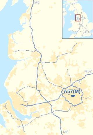
The Mancunian Way is a two mile long grade separated elevated motorway in Manchester, England. It is officially made up of the A57(M) and A635(M) motorways, although the latter does not appear on road signs for practical reasons. It is also part of two other roads: the A57 to the west, which runs east–west through Greater Manchester linking the M602 and M67 motorways, and a short section of non-motorway A635 to the east. Part of this non-motorway section collapsed on 14 August 2015 due to a sinkhole.

<span class="mw-page-title-main">A1 highway (Lithuania)</span> Highway in Lithuania

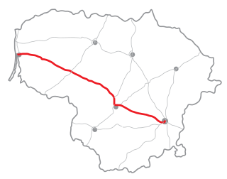
The A1 highway is a highway in Lithuania, connecting the three largest cities in the country: Vilnius, Kaunas, and Klaipėda. The highway is 311.4 kilometres (193.5 mi) long, making it the longest highway route in Lithuania.

<span class="mw-page-title-main">Autostrade of Italy</span> National motorway system of Italy

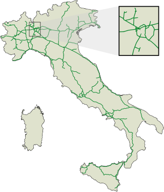
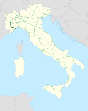
The autostrade are roads forming the Italian national system of motorways. The total length of the system is about 7,016 kilometres (4,360 mi), as of 30 July 2022. To these data are added 13 motorway spur routes, which extend for 355 kilometres (221 mi).

<span class="mw-page-title-main">Controlled-access highway</span> Highway designed for high-speed, regulated traffic flow

A controlled-access highway is a type of highway that has been designed for high-speed vehicular traffic, with all traffic flow—ingress and egress—regulated. Common English terms are freeway, motorway, and expressway. Other similar terms include throughway or thruway and parkway. Some of these may be limited-access highways, although this term can also refer to a class of highways with somewhat less isolation from other traffic.

<span class="mw-page-title-main">Bundesautobahn 10</span> Federal motorway in Germany

Bundesautobahn 10 is an orbital motorway around the German capital city of Berlin. Colloquially called Berliner Ring , it is predominantly located in the state of Brandenburg, with a short stretch of 5 km in Berlin itself. It should not be confused with the Berliner Stadtring around Berlin's inner city.

<span class="mw-page-title-main">A2 autostrada (Poland)</span> Motorway in Poland connecting Poznań, Łódź and Warsaw with Germany and Belarus

The autostrada A2 in Poland, officially named the Motorway of Freedom, is a motorway which runs from the Polish-German border, through Poznań and Łódź to Warsaw and, in the future, to the Polish-Belarusian border. It is a part of European route E30.

<span class="mw-page-title-main">A1 autostrada (Poland)</span> North–south motorway in Poland

The autostrada A1, officially named Amber Highway in Poland is a north–south motorway that runs through central Poland, from Gdańsk through Łódź and the Upper Silesian Industry Area to the Polish-Czech border in Gorzyczki/Věřňovice, where it is connected with the Czech motorway D1. Its total length is 566.6 km (352.1 mi). Except for its southernmost section, A1 is a part of European route E75.

<span class="mw-page-title-main">A6 autostrada (Poland)</span> Motorway in Poland

The autostrada A6 in Poland is a short motorway that starts at the Polish/German border at Kołbaskowo/Pomellen connecting to the German A11 autobahn. It forms a southern bypass of the Szczecin metropolitan area and terminates at Rzęśnica interchange to the east of the city, from where it continues in an expressway standard as S3 towards Świnoujście and S6 towards Gdańsk. Its length is 29.2 km (18.1 mi). The motorway is part of the European route E28.

<span class="mw-page-title-main">Autostrada A1 (Italy)</span> Motorway in Italy

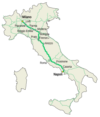
The Autostrada A1, nicknamed Autostrada del Sole, is the longest autostrada in Italy, linking some of the largest cities of the country: Milan, Bologna, Florence, Rome and Naples. It is a part of the E35 and E45 European routes.

<span class="mw-page-title-main">Autostrada A10 (Italy)</span> Controlled-access highway in Italy

The Autostrada A10, also known as the Autostrada dei Fiori or the AutoFiori, is an Italian motorway, passing through Liguria and connecting Genoa with Ventimiglia. It connects to the French A8 autoroute, which finishes in Aix-en-Provence, and forms part of European route E80. It is 158.7 kilometres (98.6 mi) long.

<span class="mw-page-title-main">Autostrada A13 (Italy)</span>

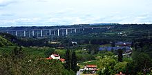
Autostrada A13 is an Italian motorway which connects Bologna to Padua, passing through Ferrara and Rovigo. It is 116.7 kilometres (72.5 mi) long. Near the two extremities of the track are situated two of the biggest Italian freight villages, in Bologna and Padua. Snow tyres are compulsory from 15 November to 15 April on the whole highway track, according to the Italian directives.

<span class="mw-page-title-main">Autostrada A91 (Italy)</span>

The Autostrada A91, also called Autostrada Roma-Fiumicino, is an Italian motorway which connects Rome to the Fiumicino Airport.

<span class="mw-page-title-main">Expressway S3 (Poland)</span> Expressway in Poland connecting Baltic Sea with Czech Republic

Expressway S3 or express road S3 is a Polish highway, which is planned to run from Świnoujście on the Baltic Sea through Szczecin, Gorzów Wielkopolski, Zielona Góra and Legnica, to the border with the Czech Republic, where it will connect to the planned D11 motorway. The total intended length is 470.6 km (292.4 mi), of which 404.7 km (251.5 mi) is open to traffic and 65.9 km (40.9 mi) is under construction as of March 2024.

<span class="mw-page-title-main">Adriatic–Ionian motorway</span> Future road in Europe

Adriatic–Ionian motorway or Trieste-Kalamata Highway or the Blue Corridor, is a future motorway that will stretch along the entire eastern shore of the Adriatic and Ionian seas, spanning the western coast of the Balkan peninsula from Italy in the north through Slovenia, Croatia, Montenegro, Albania to Greece in the south.

<span class="mw-page-title-main">Torino Lingotto railway station</span> Railway station in Turin, Italy

Torino Lingotto railway station is one of the main stations serving the city and comune of Turin, capital of the region of Piedmont, northwestern Italy. The Torino Lingotto metro station is located nearby, and opened on March 6, 2011.

<span class="mw-page-title-main">Roads in Italy</span> Overview of the various types of roads in Italy

Roads in Italy are an important mode of transport in Italy. The classification of the roads of Italy is regulated by the Italian traffic code, both from a technical and administrative point of view. The street nomenclature largely reflects the administrative classification. Italy is one of the countries with the most vehicles per capita, with 690 per 1000 people in 2010.

<span class="mw-page-title-main">Highways in Romania</span>

Controlled-access highways in Romania are dual carriageways, grade separated with controlled-access, designed for high speeds. There are two types of highways, motorways and expressways, with the main difference being that motorways have emergency lanes and slightly wider lanes. The maximum allowed speed limit for motorways is 130 km/h (81 mph), while for expressways the limit is 120 km/h (75 mph). There are no toll roads, but a road vignette is required.

<span class="mw-page-title-main">Mondovì railway station</span>

Mondovì railway station is the railway station serving the comune of Mondovì, in the Piedmont region of northwestern Italy. It is the junction of the Turin–Savona and Cuneo–Mondovì railways.

References