History
The first section of the motorway, from Bologna to Ferrara South, was opened to traffic on 22 December 1966.
On 10 August 1968 the segment from Ferrara South to Ferrara North was opened. On 7 August 1969 was inaugurated the section from Boara to Padua.
Furthermore, it was the first highway on which has been experimented foggy signage.
In 1964 it was proposed to lengthen the motorway from Padua to Treviso (another city in Veneto, Italy), and then up to Tarvisio (a small village along the borders between Italy, Austria, and Slovenia), but this was never done.
The highway today
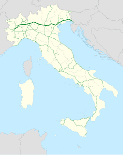
The track begins from the orbital road around Bologna, that connects the three important highways in Bologna: A13 towards Padua, A1 (Milan-Naples), A14 (Bologna-Taranto). The highway ends in Padua, at the junction with A4 (Turin-Trieste).
The whole way winds in the Pianura Padana and passes through Emilia-Romagna and Veneto. The only uplands in the surroundings are Colli Euganei, famous thermal area with Abano Terme in the middle. In fact, due to this kind of morphological features of the territory the highway crosses, during the winter-like seasons it is often present a great deal of fog, leading to a bad and reduced view.
Its management is assigned to the Italian society Autostrade per l'Italia.
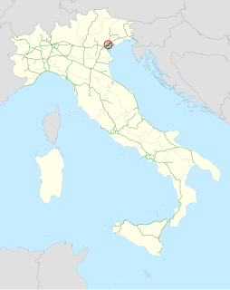
By the exit Ferrara South there is a beltway leading to Porto Garibaldi, a town on the Adriatic Sea, whose first segment (between Ferrara South and the junction with state road SS16) is owned by Autostrade per l'Italia, while from this junction up to SS309 "Romea" it is owned by ANAS. The entire beltway is called Beltway 8 and it is about 49 km long, and nowadays it is free, without any highway toll to be paid, even if in future the Government would be going to build toll booths in order to be accessible only after paying an amount.

An exit number is a number assigned to a road junction, usually an exit from a freeway. It is usually marked on the same sign as the destinations of the exit. In some countries, such as the United States, it is also marked on a sign in the gore.

The autoroute system is a network of freeways within the province of Quebec, Canada, operating under the same principle of controlled access as the Interstate Highway System in the United States and the 400-series highways in neighbouring Ontario. The Autoroutes are the backbone of Quebec's highway system, spanning almost 2,400 km (1,491 mi). The speed limit on the Autoroutes is generally 100 km/h (62 mph) in rural areas and 70–90 km/h (43–56 mph) in urban areas; most roads are made of asphalt concrete.

The National Roads and Motorways in Greece constitute the main road network of the country. These two types of roads are distinct in terms of their construction specifications. Their main difference is that motorways adhere to higher quality construction standards than National Roads.
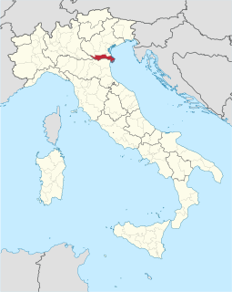
The Province of Rovigo is a province in the Veneto region of Italy. Its capital is the city of Rovigo. It borders on the north with the provinces of Verona, Padua and Venice, on the south with the province of Ferrara, on the west with the province of Mantua, and on the east with the Adriatic Sea.

The Autostrada A3 is a motorway in Southern Italy, which runs from Naples to Salerno, in the region Campania.
Until 2017 the route was much longer, going after Salerno further south until Reggio Calabria; on this year, this section became part of the new A2 motorway and of its two spur routes.

The Autostrade are roads forming the Italian national system of motorways. The total length of the system is about 6,758 kilometres (4,199 mi). In North and Central Italy, the Autostrade mainly consists of tollways managed by Autostrade per l'Italia, a holding company controlled by Cassa Depositi e Prestiti. Other operators include ASTM, ATP, and Autostrade Lombarde in the north-west; Autostrada del Brennero, A4 Holding, Concessioni Autostradali Venete, and Autovie Venete in the north-east; Strada dei Parchi, SALT, SAT, and Autocisa in the center; and CAS in the south.

The Autostrada A56, more commonly known as the Tangenziale di Napoli, is a controlled access toll road bypassing the urban center and suburban developments of Naples, Italy — connecting the SS7 near Arco Felice/Pozzuoli at the west to the A1 Autostrade at the east, with a total length of 20.2 km. The most eastward section, from Junction 3 at Doganella to the A1, is toll-free.
A toll road is a road over which users may travel over on payment of a toll, or fee. Tolls are a form of use tax that pays for the cost of road construction and maintenance, without raising taxes on non-users. Investor's bonds necessary for the construction of the roads are issued and sold with the expectation that the bonds will be paid back with user tolls. The toll roads may be run by government agencies that have bond issuing authority and/or private companies that sell bonds or have other sources of finance. Toll roads are usually a government guaranteed road monopoly that guarantees limited or no competing roads will be built by government agencies for the duration of the bonds. Private toll roads built with money raised from private investors in expectation of making money from the tolls probably dominated early toll roads. Government sponsored toll roads often guarantee a minimum payment to the bond holders if traffic volume and toll collections are less than predicted. If the toll authority is a private company there is often a maximum amount of fees that they may extract from users. Toll road operators are typically responsible for maintaining the roads. After the bonds are paid off the road typically reverts to the government agency that authorized the road and owns the land it was built on. Like most government taxes it is not unusual for tolls to continue to be charged after the bonds have been paid off.

The Autostrada A26 is a motorway in the northwestern Italian regions of Liguria and Piedmont. It is named the Autostrada dei Trafori after the numerous tunnels through which it passes, both Apennine and Subalpine. It runs northwards from Genoa on the Ligurian coast, over the Apennines, and across the wide plain of the Po valley to the environs of Lake Maggiore and the mouth of the Val d’Ossola. In addition to this ‘main trunk’ of the road, there are three side branches, also of motorway class which function as link roads between the A26 and the A7, the A4 and the A8. The A26, together with these link roads, is managed by Autostrade per l'Italia S.p.A.
The Autostrada A4, or Serenissima, is a motorway which connects Turin and Trieste via Milan and Venice. The city of Venice originally formed a bottleneck on the A4, but is now bypassed by the Passante di Mestre. The A4 passes just north of the city of Milan, where it is toll-free.

The Autostrada A6 is an Italian motorway opened in 1960 which connects Turin, the southernmost area of Piedmont, especially the Cuneo province, to the west coast of Liguria and the city of Savona. Its construction finished in 2001, when it was completely overhauled into a two-road motorway

The A15 is an Italian autostrada (motorway) connecting Parma and La Spezia through the valleys of the Taro and Magra Rivers. The road is also known as Autostrada della Cisa because it crosses the Northern Apennines at the Cisa pass. The main 101-km expanse of the motorway connects the A1 with the A12, thus directly linking the Po Valley with the Italian Riviera and the Versilia region.
The Autostrada A91, also called Autostrada Roma-Fiumicino, is an Italian motorway which connects Rome to the Fiumicino Airport.

The Milan–Bologna high-speed railway is a railway line that links the cities of Milan and Bologna, part of the Italian high-speed rail network. It runs parallel to the historical north–south railway between Milan and Bologna, which itself follows the ancient Roman Road, the Via Aemilia. The new railway follows the Autostrada A1 closely for much of its length. The new line allows faster traffic to run separated and increase the overall railway capacity between the two cities.
The GRAP is the orbital motorway surrounding Padua, northern Italy. It is also called Tangenziale di Padova.
The Tangenziale di Mestre, or Autostrada A57, was opened to traffic on 3 September 1972 in northern Italy.

Adriatic–Ionian motorway or the Blue Corridor, is a future motorway that will stretch along the entire eastern shore of the Adriatic and Ionian seas, spanning the western coast of the Balkan peninsula from Italy in the north through Croatia, Montenegro, Albania to Greece in the south.

The A1, also commonly Rruga e Kombit or SH10, is the longest and only toll motorway in Albania, stretching 114 kilometres (71 mi) in the counties of Lezhë and Kukës. It consists for the most part of two traffic lanes and an emergency lane in each driving direction separated by a central reservation.

The Autostrada A22 is one of the most important motorways in Italy, as it connects Pianura padana, the city of Modena and the A1 motorway to Austria through the Brenner Pass, located in the municipality of Brenner.

The Highways in Albania are the central state and main transport network in Albania. The motorways and expressways are both part of the national road network. The motorways are primary roads with a speed limit of 110 kilometres per hour (68 mph). They have white on green road signs such as in Italy and other countries nearby. The expressways are the secondary roads, also dual carriageways, but without an emergency lane. They have a speed limit of 90 kilometres per hour (56 mph). They have white on blue road signs.


