Italy has a well developed transport infrastructure. The Italian rail network is extensive, especially in the north, and it includes a high-speed rail network that joins the major cities of Italy from Naples through northern cities such as Milan and Turin. The Florence–Rome high-speed railway was the first high-speed line opened in Europe when more than half of it opened in 1977. Italy has 2,507 people and 12.46 km2 per kilometer of rail track, giving Italy the world's 13th largest rail network. The Italian rail network is operated by state-owned Ferrovie dello Stato, while the rail tracks and infrastructure are managed by Rete Ferroviaria Italiana.
A highway is any public or private road or other public way on land. It is used for major roads, but also includes other public roads and public tracks. In the United States, it is used as an equivalent term to controlled-access highway, or a translation for Autobahn, autostrada, autoroute, etc.
Varese is a city and comune in north-western Lombardy, northern Italy, 55 km (34 mi) north-west of Milan. The population of Varese in 2018 was 80,559.

The road hierarchy categorizes roads according to their functions and capacities. While sources differ on the exact nomenclature, the basic hierarchy comprises freeways, arterials, collectors, and local roads. Generally, the functional hierarchy can more or less correspond to the hierarchy of roads by their owner or administrator.
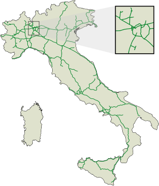
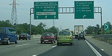
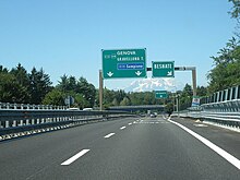
The autostrade are roads forming the Italian national system of motorways. The total length of the system is about 7,016 kilometres (4,360 mi), as of 30 July 2022. To these data are added 13 motorway spur routes, which extend for 355 kilometres (221 mi).

The Autostrada A56, more commonly known as the Tangenziale di Napoli, is a controlled access toll road bypassing the urban center and suburban developments of Naples, Italy — connecting the SS7 near Arco Felice/Pozzuoli at the west to the A1 Autostrade at the east, with a total length of 20.2 km. The most eastward section, from Junction 3 at Doganella to the A1, is toll-free.

The Autostrada A9 or Autostrada dei Laghi is an autostrada in northern Italy. It connects to the Autostrada A8 at Lainate, near Milan, and it reaches Como, on the Lake Como, and Chiasso, on the Italy–Switzerland border, where it connects to the Swiss road network.
Rescaldina is a comune (municipality) that is part of the Metropolitan City of Milan, in the Province of Milan in the Italian region Lombardy, with a population of 14,211 distributed over about 8 km2, and located about 25 kilometres (16 mi) northwest of Milan.

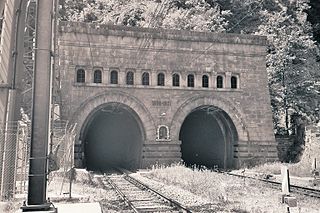
The Autostrada A26 is a motorway in the northwestern Italian regions of Liguria and Piedmont. It is named the Autostrada dei Trafori after the numerous tunnels through which it passes, both Apennine and Subalpine. It runs northwards from Genoa on the Ligurian coast, over the Apennines, and across the wide plain of the Po valley to the environs of Lake Maggiore and the mouth of the Val d’Ossola. In addition to this ‘main trunk’ of the road, there are three side branches, also of motorway class which function as link roads between the A26 and the A7, the A4 and the A8. The A26, together with these link roads, is managed by Autostrade per l'Italia S.p.A.

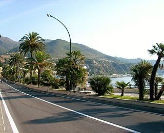
The Autostrada A10, also known as the Autostrada dei Fiori or the AutoFiori, is an Italian motorway, passing through Liguria and connecting Genoa with Ventimiglia. It connects to the French A8 autoroute, which finishes in Aix-en-Provence, and forms part of European route E80. It is 158.7 kilometres (98.6 mi) long.
The Domodossola–Milan railway line is a major Italian railway route and an important part of the European rail network. It is one of Italy's busiest lines for both passenger and freight trains. The line connects Milan and Domodossola with Brig, an important Swiss railway junction, via the Simplon Tunnel. Direct passenger trains ran from Brig to Paris and Brussels and Luxembourg via Basel. The line runs through lower Varese Province, the valley of Ossola and along the shore of Lake Maggiore.
The Strade Statali, abbreviated SS, is the Italian national network of state highways. The total length for the network is about 25,000 km (16,000 mi).

The classification of roads in Italy is regulated by the Italian traffic code, both from a technical and administrative point of view. The street nomenclature largely reflects the administrative classification. Italy is one of the countries with the most vehicles per capita, with 690 per 1000 people in 2010.

The evolution of motorways construction in European countries by total number of kilometers existing in that year. This is a list of the total number of Motorways by country in Europe. It includes motorways, classified as such by the Eurostat and includes countries that are not members of the European Union but geographically are situated in Europe.
Infrastructure before 1700 consisted mainly of roads and canals. Canals were used for transportation or for irrigation. Sea navigation was aided by ports and lighthouses. A few advanced cities had aqueducts that serviced public fountains and baths, while fewer had sewers.
The evolution of motorways construction in European Union member states by total number of kilometres existing in that year. This is a list of the total number of Motorways by country, member of the European Union. It includes motorways, classified as such by the Eurostat.

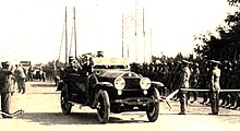
Piero Puricelli, Count of Lomnago, was an Italian engineer and politician in the first half of the 20th century who was responsible for the construction, in Italy, of the first motorways in the world. He became a senator of Italy in 1929.
The Alto Milanese is a highly populated and industrialized area of Lombardy, comprising the northwestern part of the Metropolitan City of Milan, the southern part of the province of Varese and a few municipalities of the southeastern part of the province of Como. It has an area of 235 square kilometres and a population of some 700,000 people, making it one of the most densely populated areas of Italy. Its main cities are Busto Arsizio, Legnano, Gallarate and Saronno; its main rivers are the Olona and the Ticino.