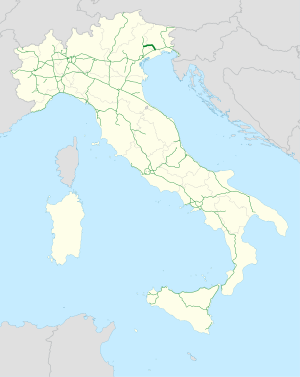
Autostrada A28 (Italy)

Last updated
Autostrada A28 Italia.svg
Autostrada A28
Italia - mappa autostrada A28.svg
Route information
Maintained by Autovie Venete S.p.A.
Length48.7 km (30.3 mi)
Existed1974–present
Major junctions
From Portogruaro
To Conegliano
Location
Country Italy
Regions Veneto, Friuli Venezia Giulia
Highway system
  • Roads in Italy

The Autostrada A28 is an Italian motorway which connects Portogruaro to Conegliano and pass through Pordenone.

Route

Autostrada A28 Italia.svg PORTOGRUARO - PORDENONE - CONEGLIANO
TipoIndicazione↓km↓Area
AB-Kreuz-grun.svg Italian traffic signs - strada europea 55.svg Italian traffic signs - strada europea 70.svg Autostrada A4 Italia.svg Torino - Trieste 0 VE
Italian traffic signs - stazione.svg Toll gate of Portogruaro 0,658
AB-AS-grun.svg Portogruaro 1,08
AB-Tank.svg Rest area Gruaro east/Gruaro west
AB-AS-grun.svg Sesto al Reghena 4,692 PN
AB-AS-grun.svg Villotta 8,672
AB-AS-grun.svg Azzano Decimo 13,951
AB-AS-grun.svg Cimpello 17,225
AB-AS-grun.svg Pordenone Centro Commerciale 20,449
AB-AS-grun.svg Pordenone 21,510
AB-AS-grun.svg Porcia 24,364
AB-Tank.svg Rest area Porcia north/Brugnera
AB-AS-grun.svg Fontanafredda 28,059
AB-AS-grun.svg Sacile East 31,129
AB-AS-grun.svg Sacile west 35,05
Italian traffic signs - stazione.svg Toll gate of Cordignano36,428 TV
AB-AS-grun.svg Godega di Sant'Urbano 43,790
AB-AS-grun.svg AB-Kreuz-grun.svg Conegliano
Autostrada A27 Italia.svg Mestre-Pian di Vedoia
48,75
A28 motorway L'A28 al km 41 in direzione A4.JPG
A28 motorway

References