
Thirunellai is a residential area in Palakkad city, Kerala, India. It is located on the banks of the Kannadi River and is about four kilometers from the district headquarters. Thirunellayi is famous for Agraharam .Thirunellayi is wards 35 and 36 of Palakkad Municipality.
Alathur is a town, taluk and gram panchayat in Palakkad District, Kerala, India. It is the administrative headquarters of the Alathur Taluk and is situated about 24 km from the district headquarters Palakkad through National Highway 544.Gayathripuzha River ,one of the tributary of Bharathapuzha,flows through Alathur. Alathur is also one among the 29 Parliamentary Constituencies in Kerala.

Attappady (HQ:Agali) is a tribal taluk in Kerala state covering an area of 735 km2 (284 sq mi). It is carved out from Mannarkkad taluk in Palakkad district on February 2021. Attappady Reserve Forest is a protected area comprising 249 km2 of land area in the western parts of Attappady. It is one among the reserved forests and protected forests of India. Attappadi valley in Palakkad district along with the neighbouring Chaliyar valley of the Nilambur region in Malappuram district, is known for natural Gold fields, which is also seen in the other regions of Nilgiri Biosphere Reserve.

Kuthiran is a mountainous terrain in Thrissur district of Kerala state, south India. It is located on the banks of Manali river, which has its source in the nearby mountains. It is in between Thrissur and Palakkad. There is a famous Ayyappan Temple located here by the side of the highway. It is in the NH544 highway. Kuthiran Tunnel is an under construction tunnel at Kuthiran.

Palakkad, also known as Palghat, is a city and municipality in the Indian state of Kerala. It is the administrative headquarters of the Palakkad District.Palakkad is one of the oldest cities in Kerala and is famous for the ancient Palakkad Fort which is situated in the heart of the city.The city is situated about 347 kilometres (216 mi) northeast of the state capital Trivandrum.

Cherpulassery is a town and municipality in the Palakkad district, of Kerala, India.. Cherpulassery is often called the Sabarimala of Malabar as the famous Ayyappankavu temple is located here. The Puthanalakkal Bhagavathi temple and the Kalavela and Pooram associated with it is one of the largest festivals in the region. The town is located about 43 km (27 mi) west of the district headquarters at Palakkad on State Highway 53. Cherpulassery is known among the football enthusiasts all across the state thanks to the football team AL Madeena,Cherpulassery.

Chengannur is a Municipality in the Alappuzha district of Kerala State, India. It is located in the extreme eastern part of the Alappuzha district, on the banks of Pamba River.

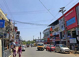
Chittur-Tattamangalam is a town,taluk and municipality in Palakkad district of Kerala State, India. It is the headquarters of Chittur taluk, 13 km (8.1 mi) away from Palakkad towards the south-east, on the banks of Kannadipuzha, a major headstream of Bharathapuzha, the second longest river in Kerala. It was once part of the erstwhile Kingdom of Cochin.

Kottiyoor is a village and Grama Panchayat situated in eastern hilly area of Kannur district in Kerala state. Kottiyoor is the 23rd Wildlife Sanctuary of Kerala, located in the serene hills of Western Ghats. The ancient pilgrimage conducted here yearly, called 'Kottiyoor Vysakha Mahotsavam' attracts thousands of devotees every year. The Vavali river flows through Kottiyoor.

Killikkurussimangalam is a village around 8 km from nearby town Ottappalam in Palakkad district of Kerala, south India. The river Nila (Bharatapuzha) flows through the southern border of Lakkidi.
Vengad is a gram panchayat situated in Thalassery taluk, Kannur district, Kerala, India, on the banks of the Anjarakandi River. Vengad is famous for its black pepper and handloom. One state seed farm is located in Vengad. Vengad gram panchayat consists of 21 wards; viz Pattathari (1), Kallayi (2), Vengad Angadi (3), Vengad Metta (4), Vengad Theru (5), Oorppalli (6), Kaitheripoyil (7), Valankichal (8), Pathiriyad (9), Pachapoika (10), Parambayi (11), Kelalur (12), Mambaram (13), Poyanad (14), Keezhathur Balavadi (15), Keezhathur Vayanasala (16), Kuzhiyil Peedika (17), Mailulli (18), Kunnirikka (19), Paduvilayi (20) and Thattari (21).
Nurani is a commercial and residential area in Palakkad city in the state of Kerala,India.It is located along Palakkad Ponnani road which connects to NH 66.Nurani contains a heritage village populated mainly by Tamil Brahmins (Iyers). This village is famous for its culture and religious fervour. About five centuries ago, Brahmins – mostly scholars, pandits, vaidikas, priests and cooks – from Thiruvannamalai in North Arcot district and other parts of Tamil Nadu came to Nurani in search of new pastures and established their dwelling in the present Agraharam (village). They brought in their Tamil culture and over years, became part and parcel of Palakkad population and their identity got merged in the new culture. Their Tamil accent and cultural milieu, in the present generation of people, can be seen distinctly different from that of the people of Tamil Nadu.

Shekharipuram is a residential area in Palakkad city,Kerala, India. Sekharipuram is famous for its agraharam or also known as heritage village. A road which starts from Sekharipuram usually known as Calicut bye pass road is a 4 lane bypass road constructed for the vehicles coming from other parts of Kerala going towards Tamil Nadu side by bypassing Palakkad city.

Wadakkancherry is a major town in Thrissur, Kerala. Up until 1860, this area was part of Chelakkara Taluk. Now, it is the headquarters of Talappilly Taluk.
Vadakkanthara is an area in Palakkad city, Kerala, India. It is located about 3 km from centre of city.Vadakkanthara is wards 43 and 50 of Palakkad Municipality.
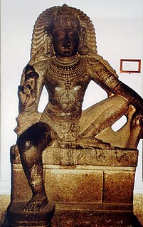
Shasta is a Hindu deity of Dravidian origin, usually associated with Shiva and Vishnu. In Hindu mythology, Shasta is considered to be another name of Ayyappan, described as the offspring of Shiva and Mohini. His principal function is to act as a kuladevata of a given clan, as well as act as a guardian of a village's boundaries. In South India, he is identified with the Ayyanar in Tamil Nadu and the Ayyappan in Kerala.
Puthur is a residential area in the city of Palakkad, in the Palakkad district in the state of Kerala, India. Puthur is wards 12 and 13 of Palakkad Municipality.
Kanjikode or Kanchikode is an industrial town located 11 km (6.8 mi) east of Palakkad. Kanjikode is a growing suburb of Palakkad city. The town is in the gram panchayat of Pudusseri within the Palakkad district of the Kerala state. It is the second largest industrial area in Kerala after Kochi .First and the only Indian Institute of Technology in Kerala, IIT Palakkad was established in Kanjikode.

Anthoor is a municipality in the Kannur district of the North Malabar region in the Indian state of Kerala. Anthoor is located roughly 15 km from the Kannur City, and 7 km from Taliparamba town.
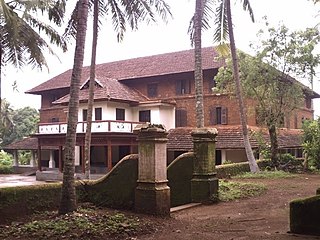
Varikkasseri Mana, alternatively known as Varikkumanchery Mana, is one of the oldest traditional aristocratic Namboothiri family houses (illam) in Kerala. Built in Kerala architectural style on a plot of land measuring approximately 4 acres, the building is located at Manissery, a village in Ottapalam in Palakkad. It is a popular shooting location for Malayalam films and several commercially successful films such as Devasuram, Aaraam Thampuran, Rappakal were filmed on its premises.


