
Brackaghlislea is a townland lying within the civil parish of Kilcronaghan, County Londonderry, Northern Ireland. It lies to the south-west of the parish and is bounded to the south and west by the civil parish of Ballinascreen. It is bounded by the following townlands: Drumard, Gortahurk, Mormeal, Tamnyaskey and Tullyroan. It was apportioned to the Drapers company and freeholds.
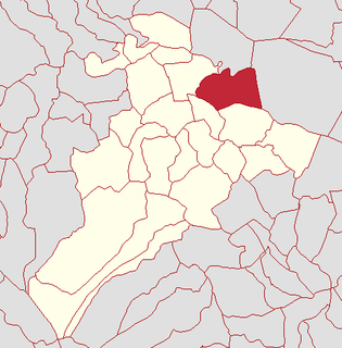
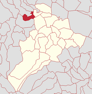
Clooney is a townland lying within the civil parish of Kilcronaghan, County Londonderry, Northern Ireland. It lies in north-east of the parish and is bounded in the north by the Moyola River as well as the parish of Termoneeny. It is bounded by the following townlands; Ballynahone Beg, Ballynahone More, Gortamney, Moyesset, and Tobermore. It was apportioned to the Drapers company as well as freeholds.
Coolsaragh is a townland lying within the civil parish of Kilcronaghan, County Londonderry, Northern Ireland. It lies in the south of the parish on the boundary with the civil parish of Desertmartin, and it is bounded by the townlands of: Annagh & Moneysterlinn, Cloughfin, Gortahurk, Keenaght, Killynumber, Killytoney, Longfield, and Tullyroan. It was apportioned to the Drapers company.
Drumballyhagan and Drumballyhagan Clark are two townlands lying within the civil parish of Kilcronaghan, County Londonderry, Northern Ireland. Situated in the north of the parish, the two townlands are separated by the Moyola River, of which the southern portion was held by a person surnamed "Clark". Together they are bounded by the townlands of; Ballynahone Beg, Bracaghreilly, Drumcrow, Fallagloon, Lisnamuck, Moneyshanere, and Tobermore. It was apportioned to the Vintners company.

Drumcrow is a townland lying within the civil parish of Kilcronaghan, County Londonderry, Northern Ireland. It lies in the north of the parish with the Moyola River running along its northern boundary. It is bounded by the townlands of; Drumballyhagan, Drumballyhagan Clark, Drumconready, Kirley Lisnamuck, Moneyshanere, and Moybeg Kirley. It was apportioned to the Vintners company.

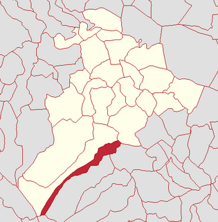
Drumsamney is a townland lying within the civil parish of Kilcronaghan, County Londonderry, Northern Ireland. It lies in the south-east of the parish on the boundary of the civil parish of Desertmartin, and is bounded by the townlands of; Annagh & Moneysterlin, Ballinderry, Killynumber, Dromore, and Gortamney. In the Plantation of Ulster it was given as a glebe to the Drapers Company.
Tobermore is a townland lying within the civil parish of Kilcronaghan, County Londonderry, Northern Ireland. It lies in the north-east of the parish, and is bounded by the townlands of; Ballynahone Beg, Calmore, Clooney, Drumballyhagan Clark, Moneyshanere, and Moyesset. It was apportioned to the Drapers company as well as freeholds.

Gortahurk is a townland lying within the civil parish of Kilcronaghan, County Londonderry, Northern Ireland. It lies on the extreme south-west of the parish on the boundary with the parish of Ballynascreen. It is bounded by the townlands of Brackaghlislea, Coolsaragh, Drumard, Keenaght, Letteran, Straw Mountain, Tintagh, and Tullyroan. It was apportioned to the Drapers company.

Cloughfin is a townland lying within the civil parish of Kilcronaghan, County Londonderry, Northern Ireland. It lies in the center of the parish, and is bounded by the following townlands: Calmore, Coolsaragh, Killytoney, and Tullyroan. It was apportioned to the Drapers company and freeholds.

Gortamney is a townland lying within the civil parish of Kilcronaghan, County Londonderry, Northern Ireland. It lies in the east of the parish alongside the boundary of the civil parish of Termoneeny, and is bounded by the townlands of Ballinderry, Ballynahone More, Clooney, Drumsamney, Killynumber, Killytoney, and Moyesset. It was apportioned to the Drapers company and Crown freeholds.

Granny is a townland lying within the civil parish of Kilcronaghan, County Londonderry, Northern Ireland. It lies in the west of the parish on the boundary of the civil parish of Ballynascreen, and is bounded by the townlands of; Calmore, Duntribryan, Moneyshanere, Mormeal, and Tamnyaskey. It wasn't apportioned to any of the London livery companies, being kept as church lands.

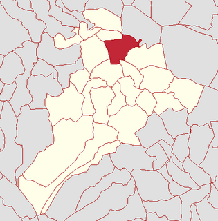
Moneyshanere is a townland lying within the civil parish of Kilcronaghan, County Londonderry, Northern Ireland. It lies in the north-west of the parish on the boundary with the civil parish of Ballynascreen, and it is bounded by the townlands of: Calmore, Drumcrow, Drumballyhagan Clark, Duntibryan, Granny, Moneyguiggy, Moybeg Kirley, and Tobermore. It was apportioned to the Drapers company and Crown freeholds.

Tullyroan is a townland lying within the civil parish of Kilcronaghan, County Londonderry, Northern Ireland. It lies in the centre of the parish and is bounded by the townlands of: Brackaghlislea, Calmore, Cloughfin, Coolsaragh, Gortahurk, Tamnyaskey. It wasn't apportioned to any of the London livery companies, being kept as church lands.

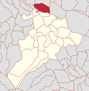
Mormeal is a townland lying within the civil parish of Kilcronaghan, County Londonderry, Northern Ireland. It lies in the west of the parish with the Altagoan river to its west forming the parish boundary with Ballynascreen. It is bounded by the townlands of: Brackaghlislea, Drumard, Duntibryan, Gortnaskey, Granny, Tamnyaskey. It wasn't apportioned to any of the London livery companies, being kept as church lands.
Moybeg Kirley is a townland lying within the civil parish of Kilcronaghan, County Londonderry, Northern Ireland. It lies in the north-west of the parish, with the Moyola River forming its northern boundary. It is bounded by the townlands of Drumconready, Drumcrow, Kirley, Moneyguiggy, and Moneyshanere. It was apportioned to the Drapers company.

Moyesset is a townland lying within the civil parish of Kilcronaghan, County Londonderry, Northern Ireland. It lies in the centre of the parish, and is bounded by the townlands of; Calmore, Clooney, Gortamney, Killytoney, and Tobermore. It was apportioned to the Drapers company and Crown freeholds.

Tamnyaskey is a townland lying within the civil parish of Kilcronaghan, County Londonderry, Northern Ireland. It lies in the west of the parish, and is bounded by the townlands of; Brackaghlislea, Calmore, Granny, Mormeal, and Tullyroan. It wasn't apportioned to any of the London livery companies, being kept as church lands.
Keenaght is a townland lying within the civil parish of Kilcronaghan, County Londonderry, Northern Ireland. It lies in the south of the parish on the boundary with the civil parish of Desertmartin, and it is bounded by the townlands of: Coolsaragh, Cullion, Gortahurk, Longfield, and Tintagh. It was apportioned to the Drapers company.

Killynumber is a townland lying within the civil parish of Kilcronaghan, County Londonderry, Northern Ireland. It lies in the south-east with the civil parish of Desertmartin, and it is bounded by the townlands of Annagh & Moneysterlin, Coolsaragh, Drumsamney, Gortamney, and Killytoney. It was apportioned to the Drapers company as well as freeholds.

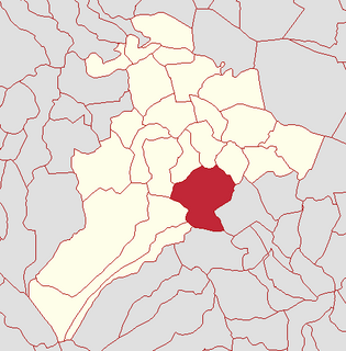
Killytoney is a townland lying within the civil parish of Kilcronaghan, County Londonderry, Northern Ireland. It lies in the center of the parish, and is bounded by the townlands of Calmore, Cloughfin, Coolsaragh, Gortamney, Killynumber, and Moyesset. It was apportioned to the Drapers company.


