Bashahr

Last updated

Bushahr State
Princely State of British India
1412–1948 Flag of India.svg
Location of Bushahr Bashar 1911.png
Location of Bushahr
1911 map of Bashahr State
History
  Established1412
   Independence of India 1948
Area
  19418,907 km2(3,439 sq mi)
Population
  1941115,000 
Density 12.9 /km2  (33.4 /sq mi)
Wikisource-logo.svg This article incorporates text from a publication now in the public domain: Chisholm, Hugh, ed. (1911). "Bushahr"  . Encyclopædia Britannica (11th ed.). Cambridge University Press.

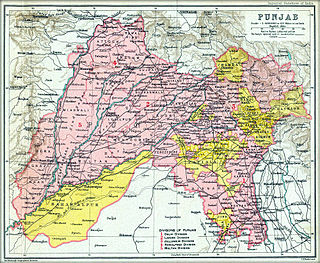
Bushahr, also spelt as 'Bashahr' and 'Bussahir' or 'Bushair' was a princely state in India during the British Raj. It was located in the hilly western Himalaya promontory in the northern part of colonial Punjab.

Princely state Type of vassal state

A princely state, also called native state, feudatory state or Indian state, was a vassal state under a local or regional ruler in a subsidiary alliance with the British Raj. Though the history of the princely states of the subcontinent dates from at least the classical period of Indian history, the predominant usage of the term princely state specifically refers to a semi-sovereign principality on the Indian subcontinent during the British Raj that was not directly governed by the British, but rather by a local ruler, subject to a form of indirect rule on some matters. In actual fact, the imprecise doctrine of paramountcy allowed the government of British India to interfere in the internal affairs of princely states individually or collectively and issue edicts that applied to all of India when it deemed it necessary.

India Country in South Asia

India, also known as the Republic of India, is a country in South Asia. It is the seventh largest country by area and with more than 1.3 billion people, it is the second most populous country as well as the most populous democracy in the world. Bounded by the Indian Ocean on the south, the Arabian Sea on the southwest, and the Bay of Bengal on the southeast, it shares land borders with Pakistan to the west; China, Nepal, and Bhutan to the northeast; and Bangladesh and Myanmar to the east. In the Indian Ocean, India is in the vicinity of Sri Lanka and the Maldives, while its Andaman and Nicobar Islands share a maritime border with Thailand and Indonesia.

British Raj British rule in the Indian subcontinent, 1858–1947

The British Raj was the rule by the British Crown in the Indian subcontinent from 1858 to 1947. The rule is also called Crown rule in India, or direct rule in India. The region under British control was commonly called British India or simply India in contemporaneous usage, and included areas directly administered by the United Kingdom, which were collectively called British India, and those ruled by indigenous rulers, but under British tutelage or paramountcy, and called the princely states. The whole was also informally called the Indian Empire. As India, it was a founding member of the League of Nations, a participating nation in the Summer Olympics in 1900, 1920, 1928, 1932, and 1936, and a founding member of the United Nations in San Francisco in 1945.

Contents

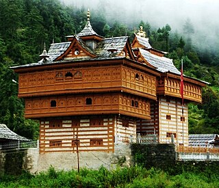
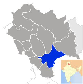
The territory of this former state is now part of Kinnaur and Shimla district of the Indian republic's state of Himachal Pradesh. The erstwhile Bushahr state was traversed by the Sutlej river. It had an area of 8,907 km².

Shimla district District in Himachal Pradesh, India

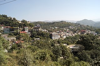
Shimla district of Himachal Pradesh lies between longitude 77.00" and 78.19" east and latitude 30.45" and 31.44" north, with its headquarters in Shimla. It is surrounded by Mandi and Kullu in the north, Kinnaur in the east, Uttarakhand in the southeast, Solan to the southwest and Sirmaur in the south. The elevation of the district ranges from 300 metres (984 ft) to 6,000 metres (19,685 ft).

Himachal Pradesh State in Northern India

Himachal Pradesh is a state in the northern part of India. Situated in the Western Himalayas, it is bordered by states of Jammu and Kashmir on the north, Punjab on the west, Haryana on the southwest, Uttarakhand on the southeast, and Tibet on the east. At its southernmost point, it also touches the state of Uttar Pradesh. The state's name was coined by acharya Diwakar Datt Sharma, one of the state's eminent Sanskrit scholars.

Sutlej river in India

The Sutlej River (Punjabi: ਸਤਲੁਜ, Sanskrit: शतद्रुम, , is the longest of the five rivers that flow through the historic crossroads region of Punjab in northern India and Pakistan. The Sutlej River is also known as Satadree It is addressed as Shatarudra by the Gorkhalis. It is the easternmost tributary of the Indus River.

History

The erstwhile Bushahr state was occupied by a Gorkha king from central Nepal from 1803 to 1815. Ranjit Singh, the ruler of the Sikh state in the Punjab, intervened in 1809 and drove the Nepalese army east of the Satluj river. A rivalry between Nepal and the British East India Company over the annexation of minor states bordering Nepal eventually led to the Anglo-Nepalese War (1815–16) or the Gurkha War. Both parties eventually signed the Treaty of Sugauli, following which the Gurkhas were expelled from Kamru, the capital of Bushahr.

Gurkha Nepalese National Soldiers

The Gurkhas or Gorkhas with endonym Gorkhali are soldiers native to the Indian subcontinent of Nepalese nationality and ethnic Nepalis of Indian nationality recruited for the British Army, Nepalese Army, Indian Army, Gurkha Contingent Singapore, Gurkha Reserve Unit Brunei, UN peacekeeping force and war zones around the world. Historically, the terms "Gurkha" and "Gorkhali" were synonymous with "Nepali", which originates from the hill principality Gorkha Kingdom, from which the Kingdom of Nepal expanded under Prithivi Narayan Shah. The name may be traced to the medieval Hindu warrior-saint Guru Gorakhnath who has a historic shrine in Gorkha. The word itself derived from "Go-Raksha", "raksha" becoming "rakha" (रखा). "Rakhawala" means "protector" and is derived from "raksha" as well.

Nepal Country in South Asia

Nepal, officially the Federal Democratic Republic of Nepal, is a landlocked country in South Asia. It is located mainly in the Himalayas but also includes parts of the Indo-Gangetic Plain. With an estimated population of 26.4 million, it is 48th largest country by population and 93rd largest country by area. It borders China in the north and India in the south, east, and west while Bangladesh is located within only 27 km (17 mi) of its southeastern tip and Bhutan is separated from it by the Indian state of Sikkim. Nepal has a diverse geography, including fertile plains, subalpine forested hills, and eight of the world's ten tallest mountains, including Mount Everest, the highest point on Earth. Kathmandu is the nation's capital and largest city. Nepal is a multiethnic nation with Nepali as the official language.

Ranjit Singh founder of Sikh Empire (early 19th century)

Maharaja Ranjit Singh was the leader of the Sikh Empire, which ruled the northwest Indian subcontinent in the early half of the 19th century. He survived smallpox in infancy but lost sight in his left eye. He fought his first battle alongside his father at age 10. After his father died, he fought several wars to expel the Afghans in his teenage years and was proclaimed as the "Maharaja of Punjab" at age 21. His empire grew in the Punjab region under his leadership through 1839.

In 1898, Bushahr state was taken over by the British administration, although the Râja remained nominally in charge. After British occupation, the Bushahr state was by far the largest of the 28 Simla Hills States. There was a tax revolt by Bushahr's peasants in 1906.

Heads of State

The original seat of the rulers of the erstwhile Bushahr state was at the Kamru Fort, in the village of Kamru at the banks of the Baspa River. The fort is currently abandoned and houses an idol of Kamakhya Devi (Kamakshi Dev), which is believed to have been brought several centuries ago from Kamakhya temple in Guwahati. The rulers subsequently moved to Sarahan. The Palace of the "Raja of Bushahr state" at Sarahan ("The Srikhand view") was built by order of Raja Padam Singh for his lodging in September 1917. The current residence of the "Raja of Bushahr state" is at the Padam Palace at Rampur, Shimla district. The town of Rampur may have been founded by Raja Kehri Singh in the 17th century or by Raja Ram Singh in the 18th. The rulers moved down from their traditional seat in Sarahan to the banks of the river Sutlej. Bushair was one of the richest princely states in the hills and was an important center for trade between Tibet, Kinnaur and the lower areas.

Baspa River

Baspa River rises near the Indo-Tibetan border and forms the Baspa Valley - one of the most scenic in Himalayas. The Chung Sakhago Pass lies at the head of the valley. It is fed by the perennial glaciers and shares the catchment area with the Ganges.

Sarahan temple and town in Himachal Pradesh, India

Sarahan is a small village in Himachal Pradesh of India. It is the site of the Bhimakali Temple, originally known as Bhimadevi Temple, dedicated to the mother goddess Bhimakali, presiding deity of the rulers of the former Bushahr State. The temple is situated about 170 kilometres from Shimla and is one of 51 Shakti Peethas. The village is known as the "gateway of Kinnaur" it being near the old Indo-Tibetan Road. Seven kilometers below Sarahan is the river Satluj. Sarahan is identified with the Shonitpur mentioned in Puranas. Sarahan Bushahr has been the summer capital of Bushahr kingdom, with Rampur Bushahr considered the winter capital. The former Chief Minister of Himachal Pradesh Shree Virbhadra Singh is a member of royal family and is popularly known as "Raja Sahab" at Sarahan. He has been member of the Assembly/Parliament since 1962 and has held the post of Chief Minister six times. His wife Rani Pratibha Devi is also a member of Assembly.

The ruling princes of Bashahr were styled as Râna before the Nepalese occupation and titled Râja afterwards. [1]

With a personal gun salute of 9 guns, the ruler of Bashahr was the only Hills "Raja" amongst India's upper class of princely salute states, but was not entitled to the style of His Highness until independence in 1947.

Rânas

  • ????: Kehri Singh
  • ????: Ram Singh
  • ???? - 1803 : Ugar Singh
  • 1803 - 1815 : Nepalese occupation

Râjas

  • 1816 - 1850 : Mahendra Singh
  • 1850 - 1887 : Shamsher Singh
  • 1887 - 1898 : Raghunath Singh
  • 1898 - 1914 : Shamsher Singh (return to power)
  • 1914 - 1947 : Padam Singh
  • 1947 - till date: Virbhadra Singh

See also

Related Research Articles

Kinnaur district District of Himachal Pradesh in India

Kinnaur is one of twelve administrative districts in the Indian state of Himachal Pradesh, India. The district is divided into three administrative areas – Pooh, Kalpa, and Nichar(Bhabanagar)– and has six tehsils (counties). The administrative headquarters of Kinnaur district is at Reckong Peo. From here Kinnaur Kailash, considered to be the abode of Lord Shiva, can be seen. As of 2011, it is the second least populous district of Himachal Pradesh, after Lahaul and Spiti, in spite of that nine vital languages are spoken in the district.

Bhajji State was a princely state in India during the period of the British Raj. Its capital was Suni. The former princely state is now part of the Indian state of Himachal Pradesh.

Kangra-Lambagraon Historical princely estate in India

Kangra-Lambagraon was a historical princely estate (jagir) located in the Punjab region. In 1947, the estate comprised 437 villages, encompassing an area of 324 km2. It had with a Privy Purse of Rs 70,000/- and enjoyed a revenue of approx. Rs.1,76,000/-.

The Hill States of India were princely states lying in the northern border regions of the British Indian Empire.

Punjab States Agency

The Punjab States Agency was a political office of the British Indian Empire. The agency was created in the 1930s, on the model of the Central India Agency and Rajputana Agency, and dealt with forty princely states in northwest India formerly dealt with by the British province of the Punjab.

Arki, India Town in Himachal Pradesh, India

Arki is a town,and a Nagar panchayat in Solan district of Himachal Pradesh, India. The town is famous for its fort built in the late 18th century when Arki was the capital of the erstwhile hill state of Baghal.

Rampur, Himachal Pradesh Town in Himachal Pradesh, India

Rampur Bushahr is a town and a municipal council in Shimla district in the Indian state of Himachal Pradesh. It is 130 km from Shimla and is well connected with National Highway 5 which passes through Narkanda.

Preneet Kaur Indian politician

Preneet Kaur is an Indian politician who served in the Government of India as a Minister of State in the Ministry of External Affairs from 2009 to 2014. She is the wife of Amarinder Singh, who is now, 26th Chief Minister of Punjab. She joined the Congress party, to which her husband also belongs, and contested parliamentary elections repeatedly from the Patiala constituency. She won the elections of 1999, 2004 and 2009, but lost her seat in the elections of 2014.

Himachal Pradesh was established in 1948 as a Chief Commissioner's Province within the Union of India. The Himachal History The province comprised the hill districts around Shimla and southern hill areas of the former Punjab region. Himachal became a part C state on 26 January 1950 with the implementation of the Constitution of India. Himachal Pradesh became a Union Territory on 1 November 1956. On 18 December 1970 the State of Himachal Pradesh Act was passed by Parliament and the new state came into being on 25 January 1971. Thus Himachal emerged as the eighteenth state of the Indian Union.

Bhimakali Temple temple at Sarahan in Himachal Pradesh in India

Shri Bhima Kali Temple is a temple at Sarahan in Himachal Pradesh in India, dedicated to the mother goddess Bhimakali, presiding deity of the rulers of former Bushahr State. The temple is situated about 180 km from Shimla and is one of 51 Shakti Peethass. The town Sarahan is known as the gate way of Kinnaur. Down below at a distance of 7 km from Sarahan is the River Satluj. Sarahan is identified with the then Sonitpur mentioned in Puranas.

Dhami princely state of the British Raj

Dhami was a Princely State situated 26 kilometres (16 mi) west of Shimla, India. Its capital was Halog and the state formed a part of the region known as the Punjab Hill States Agency during the British Raj period. In 1941 it had an area of 73 square kilometres (28 sq mi) and a population of 5,114 people. In 1948 Dhami was made a part of Himachal Pradesh.

Sirmur State

Sirmur was an independent kingdom in India, founded in 1616, located in the region that is now the Sirmaur district of Himachal Pradesh. The state was also known as Nahan, after its main city, Nahan. Sirmur was ruled by the chiefs of Rajput lineage, who used the title "Raja", later "Maharaja", granted by the British. The Rajputs of Sirmur were fierce warriors who maintained their independence before becoming a protectorate of British India. The state ranked predominant amongst the Punjab hill States. It had an area of 1198 square miles and a revenue of 300,000 rupees in 1891.

Kunihar

Kunihar is a valley town in the Solan district, which is also known as "Hatkot" and "Choti Vilayat." Kunihar is situated, alongside Kuni Rivulet,a small river or Khad in shape of garland or Har so is the name.

Mehlog or Mah(i)log was a princely state of India before and during the colonial British Raj. In 1940 it had a population of 8,631 and an area of 49 square miles (130 km2). The capital city was Patta.. Presently ruled my Rana Lalitender Chand married to Rani Krishna Kumari have two issue, Tikka Jitendra Chand married to Tikka Rani Ragini Kumari and have daughters, Baisa Shreya Sisodia and Baisa Yashshwani Sisodia.

Darkoti State was one of the Princely states of India during the period of the British Raj. Its last ruler signed the accession to the Dominion of India on 15 April 1948. Currently, it is part of the Indian state of Himachal Pradesh.

Kutlehar State

Kutlehar State, covering an area of 482 km², was one of the Princely states of India. It was reigned by Rana Amrat Pal until its occupation by Nepal from 1803 to 1815. After the annexation by Punjab in 1825 the state ceased to exist. The territory was then annexed by the British Raj and reduced to an estate (jagir). Kutlehar Estate acceded to India in 1957. Its main town was Bangana, in present-day Una district. Currently the area of the former estate is part of the Indian state of Himachal Pradesh.

Suket State

Suket State was one of the Princely states of India during the period of the British Raj. The capital of the state was Sundar Nagar. Its last ruler signed the accession to the Indian Union on 15 April 1948. Formerly it belonged to the States of the Punjab Hills and currently, it is part of the Indian state of Himachal Pradesh. The present-day Mandi district was formed with the merger of the two princely states of Mandi and Suket.

Kumharsain Town in Himachal Pradesh, India

Kumharsain better known as Kumarsain or Kumarsan was a princely state of the British Raj, located in modern day Indian state of Himachal Pradesh. It was one of the several states of Punjab States Agency. Kumarsain was a Tehsil until 2017 when it was made a sub-division of Shimla District.

Mangal is a former princely state in north India.

References

Coordinates: 31°31′12″N77°48′00″E / 31.52000°N 77.80000°E / 31.52000; 77.80000