Beitou

Last updated
Beitou
北投區
District
Beitou District

Beitou Hot Spring Valley.jpg

Hot Spring Valley in Beitou
Taipei-Beitou.svg
Country Republic of China (Taiwan)
Region Northern Taipei
Divisions
Area
  Total 56.8216 km2 (21.9389 sq mi)
Area rank Ranked 2nd of 12
Population
  Total 257,922
  Rank Ranked 5th of 12
  Density 4,500/km2 (12,000/sq mi)
Postal code112
Website www.btdo.taipei.gov.tw (in Chinese)
Beitou
Traditional Chinese 北投區
Beitou District office Beitou District Office, Taipei City 20050702.jpg
Beitou District office
Kuang Ming Road Beitou Park bus stop boards on Kuang Ming Road 20060221.jpg
Kuang Ming Road

Beitou District is the northernmost of the twelve districts of Taipei City, Taiwan. The historical spelling of the district is Peitou. The name originates from the Ketagalan word Kipatauw, meaning witch. Beitou is the most mountainous and highest of Taipei's districts, encompassing a meadow with rivers running through the valley which have abundant steam rising from them; the result of geothermal warming. The valley is often surrounded by mist shrouding the trees and grass. Beitou is famous for its hot springs. [1] In March 2012, it was named one of the Top 10 Small Tourist Towns by the Tourism Bureau of Taiwan. [2]

Districts are administrative subdivisions of Special municipalities and provincial cities of Taiwan. There are two types of district in the administrative scheme.

Taiwan is part of the collision zone between the Yangtze Plate and Philippine Sea Plate. Eastern and southern Taiwan are the northern end of the Philippine Mobile Belt.

Contents

History

In the early Japanese era, Hokuto (Pak-tau) was a village at the entrance of the well-known North Formosa sulfur district. [3] Three Japanese extracting plants in this district produced about 200 short tons (180,000 kg) of sulfur monthly. The Japanese had already recognized the value of the village as a sanitary resort and constructed a Japanese inn with hot mineral baths provided by the sulfur springs. The hot springs have been developed to include aroma therapy, massage, acupuncture, hydrotherapy, and excellent cuisine which complement the entire spa experience. The mineral waters stream from the numerous geothermal vents that occur naturally in the region and are famous for their health benefits.

Taiwan under Japanese rule Period of Taiwanese history

Taiwan was under Japanese rule between 1895 and 1945 in which the island of Taiwan was a dependency of the Empire of Japan, after Qing dynasty of China lost the First Sino-Japanese War to Japan and ceded Taiwan Province in the Treaty of Shimonoseki. The short-lived Republic of Formosa resistance movement ended to no avail when it was suppressed by Japanese troops. The fall of Tainan ended organized resistance to Japanese occupation, and inaugurated five decades of Japanese rule.

Between 1920 and 1941, Hokutō Village(北投庄) was governed under Shichisei District, Taihoku Prefecture. It was upgraded to a Hokutō Town in 1941.

Taihoku Prefecture prefecture of Taiwan under Japanese rule

Taihoku Prefecture was an administrative division of Taiwan created in 1920, during Japanese rule. The prefecture consisted of modern-day Keelung, New Taipei City, Taipei and Yilan County. Its government office, which is now occupied by the Control Yuan of Taiwan, was in Taihoku City.

Republic of China

After the handover of Taiwan from Japan to the Republic of China in 1945, it was renamed as Peitou urban township (北投鎮), belonging to Taipei County. Beginning in 1949, Peitou and Shilin were administered by the newly formed Yangmingshan Administrative Bureau. Both of them were merged into Taipei City on 1 July 1968 as districts. In 1974, Yangmingshan Administrative Bureau underwent restructuring and Beitou District was placed under direct jurisdiction of Taipei City. [4]

Retrocession Day day marking the anniversary of the end of Japanese rule over Taiwan on 25 October 1945

Taiwan Retrocession Day is an annual observance and unofficial holiday in the Republic of China to commemorate the end of 50 years of Japanese rule of Taiwan and Penghu, and their claimed handover to the Republic of China on 25 October 1945. However, the idea of "Taiwan retrocession" is in dispute.

Townships are the third-level administrative subdivisions of counties of Taiwan, along with county-controlled cities. After World War II, the townships were established from the following conversions on the Japanese administrative divisions:

Shilin District District in Northern Taipei, Republic of China

Shilin District is a district of Taipei and home to a large foreign population, mainly concentrated in the Tianmu area. It has long been a top choice for expatriates from Europe, the United States, and Japan to live, run businesses, and establish embassies and offices due mainly to the natural environment—sitting at the foot of Yangmingshan—and because the international schools are all located here. The central command of the Republic of China Navy is located in Shilin.

Economy

Asus has its headquarters in Beitou. [5]

Institutions

Education

National Yang Ming University Yang Ming University's Campus 20100905a.jpg
National Yang Ming University

Universities and colleges:

Fu Hsing Kang College

The Political Warfare Cadres Academy, also known as Fu Hsing Kang College, is a military academy in Beitou District, Taipei, Republic of China.

National Defense University (Republic of China) military university in Taiwan

National Defense University is a military academy located in Bade District, Taoyuan City, Taiwan.

National Taipei University of Nursing and Health Science

The National Taipei University of Nursing and Health Sciences is a public Medical School located in Beitou District, Taipei, Taiwan.

Junior and Senior High Schools:

Infrastructure

Tourism

Puji Temple Fusaitera01.JPG
Puji Temple

Beitou is one of the largest concentrations of hot springs and spas in the world. Once a small park where locals used to relax in the hot springs, the Beitou Valley has evolved today to include over thirty resorts; A 20-minute train ride north of Taipei takes you to Beitou. The resorts and spas are regarded by many locals and international tourists as among the most relaxing and rejuvenating places in the country. The spas consist of different degree pools (from cool to very hot) and minerals. However, residents of this district note that sulfuric fumes from the hot springs do ruin their electric appliances in the long term.

Tourist attractions

Transportation

Beitou Station Beitou Station.jpg
Beitou Station

The district is served by Beitou Station, Xinbeitou Station, Zhongyi Station, Qiyan Station, Fuxinggang Station, Guandu Station, Qilian Station, Mingde Station and Shipai Station of the Taipei Metro.

See also

Related Research Articles

Yangmingshan National park in northern Taiwan

Yangmingshan National Park is one of the nine national parks in Taiwan, located between Taipei and New Taipei City. The districts that house parts of the park grounds include Taipei's Beitou and Shilin Districts; and New Taipei's Wanli, Jinshan and Sanzhi Districts. The National Park is famous for its cherry blossoms, hot springs, sulfur deposits, fumaroles, venomous snakes, and hiking trails, including Taiwan's tallest dormant volcano, Seven Star Mountain (1,120 m).

Yangmingshan Administrative Bureau was a county level administrative body in Taiwan between 1949 and 1973.

The Beitou Cable Car Link Project (北投空中纜車) is the second cable car line in Taipei after the Maokong Gondola. It is one of the major campaign platforms of Ma Ying-jeou, the former Taipei mayor. The proposed 4.9km Beitou cable car line to ferry tourists between Xinbeitou Station and the Yangmingshan National Park would have four stops, the first of which would be built near the skating rink at Chingshui Park. It would continue to Lungfeng Valley on Yangmingshan, the first parking lot in Yangmingshan National Park, and terminate at the second parking lot.

Beitou metro station Taipei Metro Tamsui/Xinbeitou line interchange station

The Taipei Metro Beitou station is a station on Red Line, located in Beitou District, Taipei, Taiwan. The location of station can be traced back the same name station of the now-defunct TRA Tamsui Line and Xinbeitou Line.

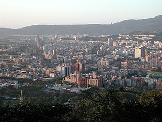
Shipai, Shihpai or Ziohbai is a region in Beitou District, Taipei, Taiwan, it includes seven villages (里): Shipai (石牌), Wenlin (文林), Ronghua (榮華), Zhenhua (振華), Yumin (裕民), Fuxing (福興), and Jianmin (建民).

Grass Mountain Chateau

The Grass Mountain Chateau is a former residence of late President of the Republic of China Chiang Kai-shek located in Beitou District, Taipei, Taiwan in Yangmingshan National Park.

Guandu metro station Taipei Metro Tamsui line station

The Taipei Metro Guandu station is located in Beitou District, Taipei, Taiwan. It is a station on the Tamsui Line. In the past, the station belonged to the now-defunct TRA Tamsui Line.

Mingde metro station Taipei Metro Tamsui line station

The Taipei Metro Mingde station is located in the Beitou District (北投區) of Taipei, Taiwan. The station is on the Tamsui Line, otherwise known as "the red line" by locals. It is also a minor bus transfer point for connections to Tianmu (天母) and Yangmingshan National Park (陽明山).

Xinbeitou metro station Taipei Metro Xinbeitou branch line station

The Taipei Metro Xinbeitou station is the terminal station on the Xinbeitou Branch Line located in Beitou District, Taipei, Taiwan. The location of the station used to be the terminal station for the now-defunct TRA Xinbeitou Line.

Jinshan District, New Taipei District in Northern Taiwan, Republic of China

Jinshan District is a rural district on the coast in northern New Taipei, Taiwan. The district draws many visitors each year because of its hot springs and its proximity to Chin Pao San and the Ju Ming Museum. The district is home to the Dharma Drum Buddhist College, an institution of higher learning founded by Dharma Drum Mountain monastics devoted to the principles of Zen Buddhism.

Beitou Hot Spring Museum Museum in Taipei, Taiwan

The Beitou Hot Spring Museum is a museum about hot spring in Beitou Park, Beitou District, Taipei, Taiwan.

Beitou Museum Museum in Taipei, Taiwan

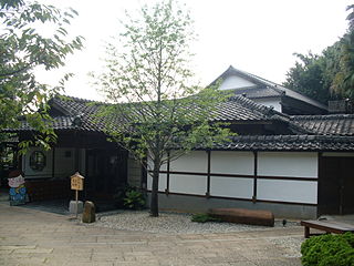
The Beitou Museum or sometimes called Taiwan Folk Arts Museum is a museum in Beitou District, Taipei, Taiwan.

Ketagalan Culture Center Cultural center in Taipei, Taiwan

The Ketagalan Culture Center is a cultural center in Beitou District, Taipei, Taiwan. The cultural center is dedicated to introduce the various Taiwanese Plains Aborigines cultures, including the Ketagalan tribes cultures.

Beitou Refuse Incineration Plant An incinerator in Taipei

The Beitou Refuse Incineration Plant is an incinerator in Zhoumei Borough, Beitou District, Taipei, Taiwan.

Thermal Valley

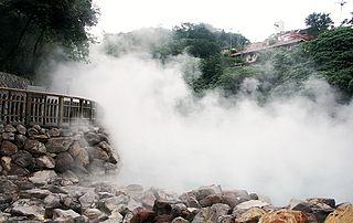
The Thermal Valley is a valley located on the foothill of Yangmingshan National Park in Beitou District, Taipei, Taiwan. This makes Thermal Valley one of the sources of acidic sulfur hot spring in the area. Locals call it as Hell Valley as well. The formula of this mineral water contains Plaster, Alunite, Jarosite, Realgar, Sulfur, and Radium. pH value is between 1.4~1.6, the highest temperature could be reached to 90 Celsius. It was one of the eight attractions and twelve scenic spots in Taiwan during the Japanese colonial period.

Beitou Park

The Beitou Park is a park in Beitou District, Taipei, Taiwan.

References

  1. Jacobs, Andrew (2010-03-21). "Taiwan's Steaming Pools of Paradise". The New York Times. Retrieved 2010-07-12.
  2. Wong, Maggie Hiufu (2012-03-30). "Taiwan names its 10 top small tourist towns". CNN Go. Retrieved 2012-03-31.
  3. Davidson, James W. (1903). The Island of Formosa, Past and Present : history, people, resources, and commercial prospects : tea, camphor, sugar, gold, coal, sulphur, economical plants, and other productions. London and New York: Macmillan. p. 621. OCLC   1887893. OL   6931635M.
  4. http://w2.dbas.taipei.gov.tw/NEWS_WEEKLY/summeng/3E.pdf
  5. "2007 Corporate Sustainability Report Archived May 21, 2009, at the Wayback Machine .." Asus. 10 of 67. Retrieved on March 15, 2010. "ASUS has its headquarters located in No. 15, Li-Te Rd., Beitou, Taipei 11259, Taiwan."

Coordinates: 25°07′00″N121°30′00″E / 25.1167°N 121.5°E / 25.1167; 121.5