
Alberto Gerchunoff, was an Argentine writer born in the Russian Empire, in the city of Proskuriv, now Khmelnytskyi, Ukraine.

Fort Garry, also known as Upper Fort Garry, was a Hudson's Bay Company trading post at the confluence of the Red and Assiniboine rivers in what is now downtown Winnipeg. It was established in 1822 on or near the site of the North West Company's Fort Gibraltar established by John Wills in 1810 and destroyed by Governor Semple's men in 1816 during the Pemmican War. Fort Garry was named after Nicholas Garry, deputy governor of the Hudson's Bay Company. It served as the centre of fur trade within the Red River Colony. In 1826, a severe flood destroyed the fort. It was rebuilt in 1835 by the HBC and named Upper Fort Garry to differentiate it from "the Lower Fort," or Lower Fort Garry, 32 km downriver, which was established in 1831. Throughout the mid-to-late 19th century, Upper Fort Garry played a minor role in the actual trading of furs, but was central to the administration of the HBC and the surrounding settlement. The Council of Assiniboia, the administrative and judicial body of the Red River Colony mainly run by Hudson's Bay Company officials, met at Upper Fort Garry.

The Red River Colony was a colonization project set up in 1811 by Thomas Douglas, 5th Earl of Selkirk, on 300,000 square kilometres (120,000 sq mi) of land. This land was granted to Douglas by the Hudson's Bay Company in the Selkirk Concession. It included portions of Rupert's Land, or the watershed of Hudson Bay, bounded on the north by the line of 52° N latitude roughly from the Assiniboine River east to Lake Winnipegosis. It then formed a line of 52° 30′ N latitude from Lake Winnipegosis to Lake Winnipeg, and by the Winnipeg River, Lake of the Woods and Rainy River.

The Battle of Seven Oaks was a violent confrontation in the Pemmican War between the Hudson's Bay Company (HBC) and the North West Company (NWC), rivals in the fur trade, that took place on 19 June 1816, the climax of a long dispute in western Canada. The Métis people fought for the North West Company, and they called it "the Victory of Frog Plain".
Thomas Douglas, 5th Earl of Selkirk FRS FRSE was a Scottish peer. He was noteworthy as a Scottish philanthropist who sponsored immigrant settlements in Canada at the Red River Colony.

St. Boniface is a city ward and neighbourhood in Winnipeg. Along with being the centre of the Franco-Manitoban community, it ranks as the largest francophone community in Western Canada.

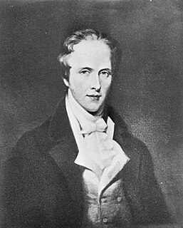
Moritz (Zvi) von Hirsch, commonly known as Maurice de Hirsch, was a German Jewish financier and philanthropist who set up charitable foundations to promote Jewish education and improve the lot of oppressed European Jewry. He was the founder of the Jewish Colonization Association, which sponsored large-scale Jewish immigration to Argentina.

Moisés Ville is a small town (comuna) in the province of Santa Fe, Argentina, founded on 23 October 1889 by Eastern European and Russian Jews escaping pogroms and persecution. The original name intended for the town was Kiryat Moshe honoring Baron Maurice Moshe Hirsch, but the land agent who registered the settlement translated it to the French-like Moïsesville which was later hispanized to the current Moisés Ville. The town is located about 177 km (110 mi) from the provincial capital, in the San Cristóbal Department and 616 km (383 mi) from Buenos Aires. It had 2,572 inhabitants at the 2001 census [INDEC].
Jewish gauchos were Jewish immigrants who settled in fertile regions of Argentina in agricultural colonies established by the Jewish Colonization Association. The association was established by Baron Maurice de Hirsch, a Jewish-French industrialist who amassed a fortune building railroads in Russia. After the death of his son, Hirsch resolved to help Russia's Jews and bought more than 80,000 hectares of land in Argentina. Among these colonies are Colonia Lapin and Rivera in the Province of Buenos Aires and Basavilbaso in Entre Ríos. Most of these immigrants were from Podolia and Bessarabia, in Imperial Russia.
Colonia Lapin is a settlement located near the town of Rivera in the southwest region of the Province of Buenos Aires, Argentina, in the Municipality of Adolfo Alsina.
A block settlement is a particular type of land distribution which allows settlers with the same ethnicity to form small colonies.

Agricultural colonies in Argentina were a demographically and economically important part of the evolution of the country. The Argentine government, faced with large areas of fertile land that were unpopulated or settled by aboriginal tribes, encouraged European immigration, welcoming settling agreements with countries, regions and associations abroad.

The West End is a mostly residential area of Winnipeg, Manitoba, Canada. It includes the neighbourhoods of Armstrong's Point, Colony, Daniel McIntyre, Minto, Sargent Park, Spence, St. Matthews, West Broadway, and Wolseley.

The Jewish Colonisation Association, in America spelled Jewish Colonization Association, is an organisation created on September 11, 1891, by Baron Maurice de Hirsch. Its aim was to facilitate the mass emigration of Jews from Russia and other Eastern European countries, by settling them in agricultural colonies on lands purchased by the committee in North America, South America and Ottoman Palestine. Today ICA is still active in Israel in supporting specific development projects under the name Jewish Charitable Association (ICA).
Rivera is a settlement located near the town of Carhué in the southwest region of the Province of Buenos Aires, Argentina, in Adolfo Alsina Partido. Rivera was founded by Jewish immigrants who came from Russia, Poland and other parts of Eastern Europe at the beginning of 20th century.

Bellegarde is a French-speaking hamlet in the rural municipality of Storthoaks No. 31, in the Canadian province of Saskatchewan, established in 1898. Bellegarde is located just south of Highway 13 or Red Coat Trail near the Manitoba border and in south eastern Saskatchewan. Cannington Manor Provincial Historic park and Moose Mountain Provincial park are near Bellegarde. This hamlet is just south of the Canadian Pacific Railway. Being a hamlet with fewer than 100 people, the population is counted within the population count of the rural municipality.

Spruce Woods Provincial Park is located in south-central Manitoba, Canada where the Assiniboine River passes through the delta of sediment left by the last glaciation. An area of open and stabilized sand dunes within the park provides habitat to species of plants and animals not found elsewhere in Manitoba. In descending order of land area contained, the park lies within the Rural Municipalities of South Cypress, Victoria, and North Cypress.

Armstrong is a rural municipality in the province of Manitoba in Western Canada. It lies in the southern area of the Interlake and was named after James William Armstrong, a Manitoba politician.
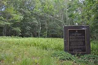
The New England Hebrew Farmers of the Emanuel Society Synagogue and Creamery Site is a complex of historic archaeological sites near the junction of Connecticut Routes 161 and 85 in Montville, Connecticut. The sites include that of a late 19th-century synagogue, and the remains of a creamery complex operated by local Jewish dairy farmers that was located nearby. It was one of the first rural Jewish settlements in the state, supported financially by the Baron de Hirsch. The site was listed on the National Register of Historic Places in 2012.
Hirsch is a hamlet in the RM of Coalfields in the Canadian province of Saskatchewan and is located about 18 miles east of the city of Estevan along Highway 18. The post office originally opened on 1 December 1893 with the town misspelled as "Hirsh". It closed on 31 March 1970.

