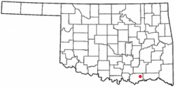
Bennington, Oklahoma | |
---|---|
[[Incorporated Town [1] ]] | |
Coordinates: 34°00′19″N96°02′18″W / 34.00528°N 96.03833°W | |
Country | United States |
State | Oklahoma |
County | Bryan |
Area | |
• Total | 0.73 sq mi (1.90 km2) |
• Land | 0.73 sq mi (1.90 km2) |
• Water | 0.00 sq mi (0.00 km2) |
Elevation | 623 ft (190 m) |
Population (2020) | |
• Total | 282 |
• Density | 384.72/sq mi (148.55/km2) |
Time zone | UTC-6 (Central (CST)) |
• Summer (DST) | UTC-5 (CDT) |
ZIP code | 74723 |
Area code | 580 |
FIPS code | 40-05400 [4] |
GNIS feature ID | 2411677 [3] |
Bennington is an incorporated town [5] in Bryan County, Oklahoma, United States. The population was 334 at the 2010 census.
In 1853, a Presbyterian minister named A. G. Lansing established Mount Pleasant Mission Station near present-day Matoy in the Choctaw Nation, Indian Territory. Lansing turned the mission operation over to Rev. Charles C. Copeland, who moved the mission a few miles farther south because the original site was in a boggy and remote location that was unhealthy. Copeland renamed the mission Bennington Mission Station, honoring his home town of Bennington, Vermont. A post office was established in 1873, but closed in 1878. It was reestablished in 1884. The peak population during this period was 45 people. [6]
At the time of its founding, Bennington was located in Blue County of the Choctaw Nation. In 1886 that portion of the county, along with portions of Atoka County and Kiamitia County, joined to form Jackson County, with its county seat at Pigeon Roost, near present-day Boswell.
The Arkansas and Choctaw Railway built through the area in 1902, and missed Bennington by two miles. Some of the buildings were dragged down to the railroad line, where a new town was established in 1903 and grew quickly to 250 people in that year. The 1910 census showed the population had about doubled to 513, then peaked at 915 in 1920, before falling to 492 in 1930. [6]
Bennington is located 20 miles (32 km) east of Durant on County Road E2075. [6]
According to the United States Census Bureau, the town has a total area of 0.6 square miles (1.6 km2), all land.
Census | Pop. | Note | %± |
---|---|---|---|
1910 | 513 | — | |
1920 | 951 | 85.4% | |
1930 | 492 | −48.3% | |
1940 | 513 | 4.3% | |
1950 | 361 | −29.6% | |
1960 | 226 | −37.4% | |
1970 | 288 | 27.4% | |
1980 | 302 | 4.9% | |
1990 | 251 | −16.9% | |
2000 | 289 | 15.1% | |
2010 | 334 | 15.6% | |
2020 | 282 | −15.6% | |
U.S. Decennial Census [7] |
As of the census [4] of 2000, there were 289 people, 100 households, and 78 families residing in the town. The population density was 514.1 inhabitants per square mile (198.5/km2). There were 124 housing units at an average density of 220.6 per square mile (85.2/km2). The racial makeup of the town was 59.52% White, 36.68% Native American, 0.69% from other races, and 3.11% from two or more races. Hispanic or Latino of any race were 1.04% of the population.
There were 100 households, out of which 42.0% had children under the age of 18 living with them, 53.0% were married couples living together, 22.0% had a female householder with no husband present, and 22.0% were non-families. 20.0% of all households were made up of individuals, and 11.0% had someone living alone who was 65 years of age or older. The average household size was 2.89 and the average family size was 3.27.
In the town, the population was spread out, with 34.3% under the age of 18, 8.7% from 18 to 24, 28.0% from 25 to 44, 16.3% from 45 to 64, and 12.8% who were 65 years of age or older. The median age was 30 years. For every 100 females, there were 90.1 males. For every 100 females age 18 and over, there were 88.1 males.
The median income for a household in the town was $17,500, and the median income for a family was $21,667. Males had a median income of $23,750 versus $18,750 for females. The per capita income for the town was $7,414. About 35.3% of families and 37.9% of the population were below the poverty line, including 34.8% of those under the age of eighteen and 29.4% of those 65 or over.
Johnston County is a county located in the U.S. state of Oklahoma. As of the 2020 census, the population was 10,272. Its county seat is Tishomingo. It was established at statehood on November 16, 1907, and named for Douglas H. Johnston, a governor of the Chickasaw Nation.
Choctaw County is a county located in the U.S. state of Oklahoma. As of the 2020 census, the population was 14,204. Its county seat is Hugo.
Bryan County is a county in the U.S. state of Oklahoma. As of the 2020 census, the population was 46,067. Its county seat is Durant. It is the only county in the United States named for Democratic politician William Jennings Bryan.
Tushka is a town in Atoka County, Oklahoma, United States. The population was 413 as of the 2020 Census, a 32.4% increase over the 312 reported at the 2010 census.
Armstrong is a town in Bryan County, Oklahoma, United States, along the Blue River. The population was 105 at the 2010 census, a 25.2 percent decrease from the figure of 141 recorded in 2000. The town was named for Frank C. Armstrong, a member of the Dawes Commission.
Bokchito is a town in Bryan County, Oklahoma, United States. The population was 632 at the 2010 census, an increase of 12.1 percent over the figure of 564 recorded in 2000. In the Choctaw language, "bok" means river, and "chito" means big or large, literally translating into "big creek".
Caddo is a town in Bryan County, Oklahoma, United States. The population was 997 at the 2010 census, a 5.6 percent gain over the figure of 944 recorded in 2000. The name is derived from a Caddo word, ka do hada’ cho, meaning "real chief" in English. According to Encyclopedia of Oklahoma History and Culture, the town was named for the nearby Caddo Hills.
Kenefic is a town in Bryan County, Oklahoma, United States. The population was 196 at the 2010 census, a 2 percent increase from the total of 192 recorded in 2000. The town was named for William Kenefick, president of the Missouri, Oklahoma and Gulf Railroad (MO&G), which had constructed a rail line through the region. The town name has been spelled both Kenefic and Kenefick throughout its history.
Boswell is a town in Choctaw County, Oklahoma, United States. The population was 709 at the 2010 census.
Fort Towson is a town in Choctaw County, Oklahoma, United States. The population was 510 at the 2010 census, a 15.1 percent decline from the figure of 611 recorded in 2000. It was named for nearby Fort Towson, which had been established in May 1824 and named for General Nathan Towson, a hero of the War of 1812. The town of Fort Towson was established in 1902, after the Arkansas and Choctaw Railway reached eastern Choctaw County.
Sawyer is a town in Choctaw County, Oklahoma, United States. The population was 321 at the 2010 census.
Kinta is a town in Haskell County, Oklahoma, United States. The population was 297 at the 2010 census, an increase of 22.2 percent over the figure of 243 recorded in 2000.
Calvin is a town in Hughes County, Oklahoma, United States. The population was 294 at the 2010 census.
Wapanucka is a town in northeastern Johnston County, Oklahoma, United States. The population was 386 as of the 2020 Census. It is about 20 miles (32 km) northeast of Tishomingo. The town name refers to the Delaware Nation and means "Eastern Land People."
Fort Coffee is a town in Le Flore County, Oklahoma, United States. Originally constructed as a U. S. Army fort in 1834, it was named for U. S. General John Coffee, a veteran of the Seminole Wars. It is part of the Fort Smith, Arkansas-Oklahoma Metropolitan Statistical Area. The population was 424 at the 2010 census, a gain of 2.9 percent over the figure of 412 in 2000.
Talihina is a town in LeFlore County, Oklahoma, United States, its name originating from two Choctaw words, tully and hena, meaning "iron road," a reference to the railroad around which the town was built. It is part of the Fort Smith, Arkansas–Oklahoma Metropolitan Statistical Area. The population was 925 at the time of the 2020 Census.
Alderson is a town in Pittsburg County, Oklahoma, United States. The population was 304 at the 2010 census.
Crowder is a town in Pittsburg County, Oklahoma, United States. The population was 430 at the 2010 census.
Quinton is a town in Pittsburg County, Oklahoma, United States. The population was 1,051 at the 2010 census. The town was named for Elizabeth Quinton, who lived to be 116 years old. Her family still resides in and around the town of Quinton. Web address https://townofquinton.com/
Fanshawe is a town in Latimer and Le Flore counties in the U.S. state of Oklahoma. As of the 2020 Census, the town had a total population of 317. The Le Flore County portion of Fanshawe is part of the Fort Smith, Arkansas-Oklahoma Metropolitan Statistical Area.