Hyde is a town in Tameside, Greater Manchester, England, which had a population of 35,890 in 2021. Within the boundaries of the historic county of Cheshire, it is 5 miles (8 km) north-east of Stockport, 6 miles (10 km) west of Glossop and 6.5 miles (10 km) east of Manchester.
North Manchester was, from 1896 to 1916, a township within the Poor Law Union of Manchester, England. North Manchester was a local government sub-district used for the administration of Poor Law legislation; it was an inter-parish unit for social security. Although abolished in 1916, the name North Manchester endured for the area, and is still applied to the northern parts of the city, for instance as a registration district up until 1974.

Haydock is a village within the Metropolitan Borough of St Helens, in Merseyside, England. At the 2011 Census, it had a population of 11,416 Haydock's historic area covers the Haydock electoral ward and a section of the Blackbrook ward.

Beswick is an inner city area in Manchester, England. It consists of the ancient township of Beswick, Manchester, which is in the ancient parish of Manchester and hundred of Salford.

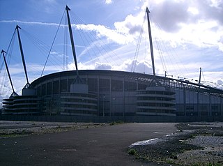
Bradford is a district of east Manchester, in Greater Manchester, England, two miles north east of the city centre. The population at the 2011 census was 15,784. Historically in Lancashire, after the closure of its heavy industries Bradford was for many years an economically deprived area but has undergone regeneration with the building of the City of Manchester Stadium which hosted the 2002 Commonwealth Games and is now home to Manchester City F.C. Bradford is neighboured by Beswick to the south and the two areas are sometimes referred to as Bradford-with-Beswick. The River Medlock and the Ashton Canal run through Bradford.

Breightmet is a neighbourhood of Bolton, in Greater Manchester, England. The population of the ward taken at the 2011 census was 13,584. Historically a township of the civil and ecclesiastical parish of Bolton le Moors in the Salford hundred of Lancashire, it lies 2 miles (3.2 km) north-east of Bolton and 4 miles (6.4 km) north-west of Bury.

Bardsley is a suburban area of Oldham, in Greater Manchester, England.

Sportcity in Manchester is a multipurpose sports and leisure facility. Originally built to host the 2002 Commonwealth Games, it is in east Manchester, North West England, a mile from Manchester city centre, and was developed on former industrial land including the site of Bradford Colliery.

Ribbleton is a suburb and ward of the city of Preston, Lancashire, England. It is located to the east of the city centre, between the A59 New Hall Lane and the B6243 Longridge Road. The M6 motorway also runs through the area. The ward had a population of 7,351 recorded in the 2001 census increasing to 8,548 at the 2011 Census.

The Municipal Borough of Farnworth was a local government district centred on the town of Farnworth in the administrative county of Lancashire, England. A local board of health had been established for Farnworth in 1863, which was reconstituted as an urban district in 1899, before being granted a charter of incorporation to become a municipal borough in 1939. Following abolition of the local authority in 1974, Farnworth became an unparished area of the Metropolitan Borough of Bolton in Greater Manchester.

Kenyon is a village and former civil parish, now in the parish of Croft, in the Warrington district, in the ceremonial county of Cheshire, England. In 1931 the parish had a population of 259.
Great Bolton was a township of the civil and ecclesiastical parish of Bolton le Moors in the Salford hundred of Lancashire, England. Despite its name, Great Bolton had a smaller acreage than its northern neighbour Little Bolton from which it was separated by the River Croal.

Little Bolton was a township of the civil and ecclesiastical parish of Bolton le Moors in the Salford hundred of Lancashire, England. Besides the main part of Little Bolton, it had three detached parts which were separated by areas of Lower Sharples and Higher Sharples. Despite its name, Little Bolton had a larger acreage than its southern neighbour Great Bolton, from which it was separated by the River Croal.
Tonge with Haulgh was a township of the civil and ecclesiastical parish of Bolton le Moors in the Salford hundred of Lancashire, England.

Longworth was a township of the civil and ecclesiastical parish of Bolton le Moors in the Salford hundred of Lancashire, England. In 1891 it had a population of 102.
Blackrod was, from 1872 to 1974, a local government district centred on the village of Blackrod in the administrative county of Lancashire, England.
Horwich was, from 1872 to 1974, a local government district centred on the town of Horwich in the administrative county of Lancashire, England.
Kearsley was, from 1865 to 1974, a local government district centred on the town of Kearsley in the administrative county of Lancashire, England.
Little Lever was, from 1872 to 1974, a local government district centred on the large village of Little Lever in the administrative county of Lancashire, England.

Westhoughton was, from 1872 to 1974, a local government district centred on the town of Westhoughton in the administrative county of Lancashire, England.


