Bharoli

Last updated

Bharoli
Village
India Punjab location map.svg
Red pog.svg
Bharoli
Location in Punjab, India
India location map.svg
Red pog.svg
Bharoli
Bharoli (India)
Coordinates: 31°14′25″N75°52′55″E / 31.2403431°N 75.8819353°E / 31.2403431; 75.8819353 Coordinates: 31°14′25″N75°52′55″E / 31.2403431°N 75.8819353°E / 31.2403431; 75.8819353
CountryFlag of India.svg  India
State Punjab
District Shaheed Bhagat Singh Nagar
Government
  Type Panchayat raj
  Body Gram panchayat
Elevation 254 m (833 ft)
Population (2011)
  Total 2,202 [1]
  Sex ratio / 1132/1070
Languages
  Official Punjabi
Time zone IST (UTC+5:30)
PIN 144503
Telephone code 01823
ISO 3166 code IN-PB
Post office Pharala [2]
Website nawanshahr.nic.in

Bharoli is a village in Shaheed Bhagat Singh Nagar district of Punjab State, India. It is located 3.5 kilometres (2.2 mi) away from postal head office Pharala, 15.5 kilometres (9.6 mi) from Banga, 29.4 kilometres (18.3 mi) from district headquarter Shaheed Bhagat Singh Nagar and 119 kilometres (74 mi) from state capital Chandigarh. The village is administrated by Sarpanch an elected representative of the village. [3]

Shaheed Bhagat Singh Nagar district District in Punjab, India

Shaheed Bhagat Singh Nagar district is one of the districts in Doaba region of the state of Punjab in North-West Republic of India. It consists of three Sub -Divisions Nawanshahr, Banga and Balachaur. There are three legislative seats in the district, Nawanshahr, Balachaur and Banga. They fall under the Anandpur Sahib Lok Sabha Constituency.

Punjab, India State in Northern India

Punjab is a state in northern India. Forming part of the larger Punjab region of the Indian subcontinent, the state is bordered by the Indian states of Jammu and Kashmir to the north, Himachal Pradesh to the east, Haryana to the south and southeast, Rajasthan to the southwest, and the Pakistani province of Punjab to the west. The state covers an area of 50,362 square kilometres, 1.53% of India's total geographical area. It is the 20th-largest Indian state by area. With 27,704,236 inhabitants at the 2011 census, Punjab is the 16th-largest state by population, comprising 22 districts. Punjabi is the most widely spoken and official language of the state. The main ethnic group are the Punjabis, with Sikhs (58%) forming the demographic majority. The state capital is Chandigarh, a Union Territory and also the capital of the neighbouring state of Haryana. The five rivers from which the region took its name were Sutlej, Ravi, Beas, Chenab and Jhelum; Sutlej, Ravi and Beas are part of the Indian Punjab.

Banga, India c in Punjab, India

Banga is a town and Municipal council in the Shahid Bhagat Singh Nagar district of Punjab, India. Banga is also one of the sub-division (tehsil) headquarters of the district. Banga located on Phagwara-Rupnagar section of National Highway 344A. It is currently estimated to have a population of about 23,000 and is classified as a class 2 Municipality. The town also incorporates the former village of Jindowal apart from Banga town.

Contents

Demography

As of 2011, Bharoli has a total number of 470 houses and population of 2202 of which include 1132 are males while 1070 are females according to the report published by Census India in 2011. The literacy rate of Bharoli is 82.87%, higher than the state average of 75.84%. The population of children under the age of 6 years is 211 which is 9.58% of total population of Bharoli, and child sex ratio is approximately 1049 as compared to Punjab state average of 846. [1] [4]

The 15th Indian Census was conducted in two phases, house listing and population enumeration. House listing phase began on 1 April 2010 and involved collection of information about all buildings. Information for National Population Register was also collected in the first phase, which will be used to issue a 12-digit unique identification number to all registered Indian residents by Unique Identification Authority of India (UIDAI). The second population enumeration phase was conducted between 9 and 28 February 2011. Census has been conducted in India since 1872 and 2011 marks the first time biometric information was collected. According to the provisional reports released on 31 March 2011, the Indian population increased to 1.21 billion with a decadal growth of 17.70%. Adult literacy rate increased to 74.04% with a decadal growth of 9.21%. The motto of the census was 'Our Census, Our future'.

Literacy ability to read for knowledge, write coherently, and think critically about the written word; ability to read, write, and use arithmetic

Dictionaries traditionally define literacy as the ability to read and write. In the modern world, this is one way of interpreting literacy. One more broad interpretation sees literacy as knowledge and competence in a specific area. The concept of literacy has evolved in meaning. The modern term's meaning has been expanded to include the ability to use language, numbers, images, computers, and other basic means to understand, communicate, gain useful knowledge, solve mathematical problems and use the dominant symbol systems of a culture. The concept of literacy is expanding across OECD countries to include skills to access knowledge through technology and ability to assess complex contexts. A person who travels and resides in a foreign country but is unable to read or write in the language of the host country would be regarded by the locals as illiterate.

In India, the Child Sex Ratio is defined as the number of females per thousand males in the age group 0–6 years in a human population. Thus it is equal to 1000 x the reciprocal of the sex ratio in the same age group, i.e. under age seven. An imbalance in this age group will extend to older age groups in future years. Currently, the ratio of males to females is generally significantly greater than 1, i.e. there are more boys than girls.

Most of the people are from Schedule Caste which constitutes 48.77% of total population in Bharoli. The town does not have any Schedule Tribe population so far. [1]

Scheduled Castes and Scheduled Tribes official designations given to various groups indigenous people in India

The Scheduled Castes (SCs) and Scheduled Tribes (STs) are officially designated groups of historically disadvantaged people in India. The terms are recognised in the Constitution of India and the groups are designated in one or other of the categories. For much of the period of British rule in the Indian subcontinent, they were known as the Depressed Classes. The people in scheduled castes are essentially the lowest part of Hindu society.

As per the report published by Census India in 2011, 696 people were engaged in work activities out of the total population of Bharoli which includes 619 males and 77 females. According to census survey report 2011, 90.52% workers describe their work as main work and 9.48% workers are involved in Marginal activity providing livelihood for less than 6 months. [1] [5]

A person's livelihood refers to their "means of securing the basic necessities -food, water, shelter and clothing- of life". Livelihood is defined as a set of activities performed to live for a given life span , involving securing water, food, fodder, medicine, shelter, clothing and the capacity to acquire above necessities working either individually or as a group by using endowments for meeting the requirements of the self and his/her household on a sustainable basis with dignity. The activities are usually carried out repeatedly. For instance, a fisherman's livelihood depends on the availability and accessibility of fish.

Education

The village has a Punjabi medium, co-ed upper primary school founded in 1978. [6] [7] The schools provide mid-day meal as per Indian Midday Meal Scheme. [8] The school provide free education to children between the ages of 6 and 14 as per Right of Children to Free and Compulsory Education Act.

Midday Meal Scheme

The Midday Meal Scheme is a school meal programme of the Government of India designed to better the nutritional standing of school-age children nationwide. The programme supplies free lunches on working days for children in primary and upper primary classes in government, government aided, local body, Education Guarantee Scheme, and alternate innovative education centres, Madarsa and Maqtabs supported under Sarva Shiksha Abhiyan, and National Child Labour Project schools run by the ministry of labour. Serving 120,000,000 children in over 1,265,000 schools and Education Guarantee Scheme centres, it is the largest of its kind in the world.

Amardeep Singh Shergill Memorial college Mukandpur and Sikh National College Banga are the nearest colleges. [6] Lovely Professional University is 22 kilometres (14 mi) away from the village.

Lovely Professional University

Lovely Professional University (LPU) is a private university situated in Jalandhar, Punjab, India. The university was established in 2005 by Lovely International Trust, under The Lovely Professional University Act, 2005 and started operation in 2006. With 24,000 students in 2010, it claims to be the largest single-campus private university in India.

Transport

Banga railway station is the nearest train station however, Nawanshahr railway station is 29 kilometres (18 mi) away from the village. Sahnewal Airport is the nearest domestic airport which located 68 kilometres (42 mi) away in Ludhiana and the nearest international airport is located in Chandigarh also Sri Guru Ram Dass Jee International Airport is the second nearest airport which is 135 kilometres (84 mi) away in Amritsar. [9]

See also

Related Research Articles

Jagatpur, Punjab Village in Punjab, India

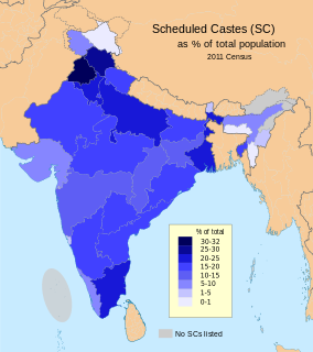
Jagatpur is a village in Shaheed Bhagat Singh Nagar district of Punjab State, India. It is located 2.2 kilometres (1.4 mi) away from postal head office Mukandpur, 9.3 kilometres (5.8 mi) from Banga, 12 kilometres (7.5 mi) from district headquarter Shaheed Bhagat Singh Nagar and 113 kilometres (70 mi) from state capital Chandigarh. The village is administrated by Sarpanch an elected representative of the village.

Chak Guru Village in Punjab, India

Chak Guru is a village in Shaheed Bhagat Singh Nagar district of Punjab State, India. It is located 9.2 kilometres (5.7 mi) away from Garhshankar, 17.6 kilometres (10.9 mi) from Balachaur, 17 kilometres (11 mi) from district headquarter Shaheed Bhagat Singh Nagar and 87 kilometres (54 mi) from state capital Chandigarh. The village is administrated by Sarpanch an elected representative of the village.

Talwandi Jattan Village in Punjab, India

Talwandi Jattan is a village in Shaheed Bhagat Singh Nagar district of Punjab State, India. It is located 2.2 kilometres (1.4 mi) away from postal head office Behram, 11.9 kilometres (7.4 mi) from Banga, 23.5 kilometres (14.6 mi) from district headquarter Shaheed Bhagat Singh Nagar and 115 kilometres (71 mi) from state capital Chandigarh. The village is administrated by Sarpanch an elected representative of the village.

Mazara Nauabad Village in Punjab, India

Mazara Nauabad or Mazara Nau Abad is a village in Shaheed Bhagat Singh Nagar district of Punjab State, India. It is located 5.2 kilometres (3.2 mi) away from Banga, 15.8 kilometres (9.8 mi) from Apra, 8.5 kilometres (5.3 mi) from district headquarter Shaheed Bhagat Singh Nagar and 108 kilometres (67 mi) from state capital Chandigarh. The village is administrated by Sarpanch an elected representative of the village.

Laroya, Punjab Village in Punjab, India

Laroya is a village in Shaheed Bhagat Singh Nagar district of Punjab State, India. It is located 7.2 kilometres (4.5 mi) away from postal head office Mukandpur, 12 kilometres (7.5 mi) from Banga, 15 kilometres (9.3 mi) from district headquarter Shaheed Bhagat Singh Nagar and 106 kilometres (66 mi) from state capital Chandigarh. The village is administrated by Sarpanch an elected representative of the village.

Paragpur Village in Punjab, India

Paragpur is a village in Shaheed Bhagat Singh Nagar district of Punjab State, India. It is located 8 kilometres (5.0 mi) away from postal head office Mukandpur, 11 kilometres (6.8 mi) from Banga, 15.3 kilometres (9.5 mi) from district headquarter Shaheed Bhagat Singh Nagar and 106 kilometres (66 mi) from state capital Chandigarh. The village is administrated by Sarpanch an elected representative of the village.

Begowal, Nawanshahr Village in Punjab, India

Begowal is a village in Shaheed Bhagat Singh Nagar district of Punjab State, India. It is situated on Phambra-Begowal link road and located 18.2 kilometres (11.3 mi) away from postal head office Kahma, 15 kilometres (9.3 mi) from Rahon, 17 kilometres (11 mi) from district headquarter Shaheed Bhagat Singh Nagar and 103 kilometres (64 mi) from state capital Chandigarh. The village is administrated by Sarpanch an elected representative of the village.

Dosanjh Khurd Village in Punjab, India

Dosanjh Khurd is a village in Shaheed Bhagat Singh Nagar district of Punjab State, India. It is located 3.9 kilometres (2.4 mi) away from Banga, 12 kilometres (7.5 mi) from Nawanshahr, 9.3 kilometres (5.8 mi) from district headquarter Shaheed Bhagat Singh Nagar and 103 kilometres (64 mi) from state capital Chandigarh. The village is administrated by Sarpanch an elected representative of the village.

Godani, SBS Nagar Village in Punjab, India

Godani is a village in Shaheed Bhagat Singh Nagar district of Punjab State, India. It is located 10 kilometres (6.2 mi) away from Banga, 24 kilometres (15 mi) from Nawanshahr, 21 kilometres (13 mi) from district headquarter Shaheed Bhagat Singh Nagar and 114 kilometres (71 mi) from state capital Chandigarh. The village is administrated by Sarpanch an elected representative of the village.

Kahma Village in Punjab, India

Kahma is a village in Shaheed Bhagat Singh Nagar district of Punjab State, India. It is situated on Phagwara-Mohali expressway located 5.4 kilometres (3.4 mi) away from Banga, 9 kilometres (5.6 mi) from Nawanshahr, 10.4 kilometres (6.5 mi) from district headquarter Shaheed Bhagat Singh Nagar and 96 kilometres (60 mi) from state capital Chandigarh. The village is administrated by Sarpanch an elected representative of the village.

Katt Village in Punjab, India

Katt is a village in Shaheed Bhagat Singh Nagar district of Punjab State, India. It is located 11 kilometres (6.8 mi) away from postal head office Banga, 25 kilometres (16 mi) from Nawanshahr, 22 kilometres (14 mi) from district headquarter Shaheed Bhagat Singh Nagar and 115 kilometres (71 mi) from state capital Chandigarh. The village is administrated by Sarpanch an elected representative of the village.

Khamachon Village in Punjab, India

Khamachon is a village in Shaheed Bhagat Singh Nagar district of Punjab State, India. It is located 2.8 kilometres (1.7 mi) away from postal head office Banga, 13.5 kilometres (8.4 mi) from Nawanshahr, 12 kilometres (7.5 mi) from district headquarter Shaheed Bhagat Singh Nagar and 103 kilometres (64 mi) from state capital Chandigarh. The village is administrated by Sarpanch an elected representative of the village.

Khoja, SBS Nagar Village in Punjab, India

Khoja is a village in Shaheed Bhagat Singh Nagar district of Punjab State, India. It is located 17 kilometres (11 mi) away from postal head office Banga, 18 kilometres (11 mi) from Nawanshahr, 11 kilometres (6.8 mi) from district headquarter Shaheed Bhagat Singh Nagar and 100 kilometres (62 mi) from state capital Chandigarh. The village is administrated by Sarpanch an elected representative of the village.

Kultham Village in Punjab, India

Kultham is a village in Shaheed Bhagat Singh Nagar district of Punjab State, India. It is located 15 kilometres (9.3 mi) away from Banga, 10 kilometres (6.2 mi) from Phagwara, 27 kilometres (17 mi) from district headquarter Shaheed Bhagat Singh Nagar and 119 kilometres (74 mi) from state capital Chandigarh. The village is administrated by Sarpanch an elected representative of the village.

Ladhana Jhikka Village in Punjab, India

Ladhana Jhikka is a village in Shaheed Bhagat Singh Nagar district of Punjab State, India. It is located 9.7 kilometres (6.0 mi) away from Banga, 18 kilometres (11 mi) from Nawanshahr, 16.8 kilometres (10.4 mi) from district headquarter Shaheed Bhagat Singh Nagar and 108 kilometres (67 mi) from state capital Chandigarh. The village is administrated by Sarpanch an elected representative of the village.

Mahalon, SBS Nagar Village in Punjab, India

Mahalon is a village in Shaheed Bhagat Singh Nagar district of Punjab State, India. It is located 3.7 kilometres (2.3 mi) away from postal head office Nawanshahr, 11.9 kilometres (7.4 mi) from Banga, 3.2 kilometres (2.0 mi) from district headquarter Shaheed Bhagat Singh Nagar and 91.2 kilometres (56.7 mi) from state capital Chandigarh. The village is administrated by Sarpanch an elected representative of the village.

Mahliana Village in Punjab, India

Mahliana is a village in Shaheed Bhagat Singh Nagar district of Punjab State, India. It is located 7.8 kilometres (4.8 mi) away from post office Mahil Gailan, 33 kilometres (21 mi) from Nawanshahr, 31 kilometres (19 mi) from district headquarter Shaheed Bhagat Singh Nagar and 123 kilometres (76 mi) from state capital Chandigarh. The village is administrated by Sarpanch an elected representative of the village.

Mander, SBS Nagar Village in Punjab, India

Mander is a village in Shaheed Bhagat Singh Nagar district of Punjab State, India. It is located 6.5 kilometres (4.0 mi) away from sub post office Khan Khana, 25 kilometres (16 mi) from Nawanshahr, 16.5 kilometres (10.3 mi) from district headquarter Shaheed Bhagat Singh Nagar and 115 kilometres (71 mi) from state capital Chandigarh. The village is administrated by Sarpanch an elected representative of the village.

Nurpur, SBS Nagar Village in Punjab, India

Nurpur is a village in Shaheed Bhagat Singh Nagar district of Punjab State, India. It is located 1.1 kilometres (0.68 mi) away from branch post office Sarhal Qazian, 27 kilometres (17 mi) from Nawanshahr, 22 kilometres (14 mi) from district headquarter Shaheed Bhagat Singh Nagar and 117 kilometres (73 mi) from state capital Chandigarh. The village is administrated by Sarpanch an elected representative of the village.

Sal Kalan Village in Punjab, India

Sal Kalan is a village in Shaheed Bhagat Singh Nagar district of Punjab State, India. It is located 6 kilometres (3.7 mi) away from sub post office Banga, 20 kilometres (12 mi) from Nawanshahr, 17.7 kilometres (11.0 mi) from district headquarter Shaheed Bhagat Singh Nagar and 110 kilometres (68 mi) from state capital Chandigarh. The village is administrated by Sarpanch an elected representative of the village.

References