
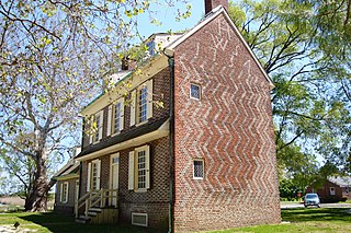
Alloway Township is a township in Salem County, New Jersey, United States. As of the 2010 United States Census, the township's population was 3,467, reflecting an increase of 693 (+25.0%) from the 2,774 counted in the 2000 Census, which had in turn declined by 21 (-0.8%) from the 2,795 counted in the 1990 Census. What is now Alloway was formally incorporated as Upper Alloways Creek Township by a Royal charter granted on June 17, 1767, from portions of the now-defunct Alloways Creek Township. The township was formally incorporated by an act of the New Jersey Legislature on February 21, 1798. Quinton Township was formed from portions of the township on February 18, 1873. The name was officially changed to Alloway Township as of February 21, 1884.

Carneys Point Township is a township in Salem County, New Jersey, United States. As of the 2010 United States Census, the township's population was 8,049, reflecting an increase of 365 (+4.8%) from the 7,684 counted in the 2000 Census, which had in turn declined by 759 (-9.0%) from the 8,443 counted in the 1990 Census.

Elmer is a borough in Salem County in the U.S. state of New Jersey. As of the 2010 United States Census, the borough's population was 1,395, reflecting an increase of 11 (+0.8%) from the 1,384 counted in the 2000 Census, which had in turn declined by 187 (-11.9%) from the 1,571 counted in the 1990 Census. It is the home of the annual Appel Farm Arts and Music Festival, which celebrated its 23rd year in 2012.

Elsinboro Township is a township in Salem County, New Jersey, United States. As of the 2010 United States Census, the township's population was 1,036, reflecting a decline of 56 (-5.1%) from the 1,092 counted in the 2000 Census, which had in turn declined by 78 (-6.7%) from the 1,170 counted in the 1990 Census.
Lower Alloways Creek Township is a township in Salem County, in the U.S. state of New Jersey. As of the 2010 United States Census, the township's population was 1,770, reflecting a decline of 81 (-4.4%) from the 1,851 counted in the 2000 Census, which had in turn declined by 7 (-0.4%) from the 1,858 counted in the 1990 Census.

Oldmans Township is a township in Salem County, New Jersey, United States. As of the 2010 United States Census, the township's population was 1,773, reflecting a decline of 25 (-1.4%) from the 1,798 counted in the 2000 Census, which had in turn increased by 115 (+6.8%) from the 1,683 counted in the 1990 Census.

Penns Grove is a borough in Salem County, New Jersey, United States. As of the 2010 United States Census, the borough's population was 5,147, reflecting an increase of 261 (+5.3%) from the 4,886 counted in the 2000 Census, which had in turn declined by 342 (-6.5%) from the 5,228 counted in the 1990 Census.

Pennsville Township is a township in Salem County, in the U.S. state of New Jersey. As of the 2010 United States Census, the township's population was 13,409, reflecting an increase of 215 (+1.6%) from the 13,194 counted in the 2000 Census, which had in turn declined by 600 (-4.3%) from the 13,794 counted in the 1990 Census. The township is named for William Penn. The township includes the state's westernmost point.

Pilesgrove Township is a township in Salem County, New Jersey, United States. As of the 2010 United States Census, the township's population was 4,016, reflecting an increase of 93 (+2.4%) from the 3,923 counted in the 2000 Census, which had in turn increased by 673 (+20.7%) from the 3,250 counted in the 1990 Census.
Pittsgrove Township is a township in Salem County, in the U.S. state of New Jersey. As of the 2010 United States Census, the township's population was 9,393, reflecting an increase of 500 (+5.6%) from the 8,893 counted in the 2000 Census, which had in turn increased by 772 (+9.5%) from the 8,121 counted in the 1990 Census.

Quinton Township is a township in Salem County, in the U.S. state of New Jersey. As of the 2010 United States Census, the township's population was 2,666, reflecting a decline of 120 (-4.3%) from the 2,786 counted in the 2000 Census, which had in turn increased by 275 (+11.0%) from the 2,511 counted in the 1990 Census.

Salem is a city in Salem County, in the U.S. state of New Jersey. As of the 2010 United States Census, the city's population was 5,146, reflecting a decrease of 711 (−12.1%) from the 5,857 counted in the 2000 Census, which had in turn declined by 1,026 (−14.9%) from the 6,883 counted in the 1990 Census, an overall drop of more than 25% over the two decades. It is the county seat of Salem County, the state's most rural county. The name "Salem", in both the city and county, is derived from the Hebrew word shalom, meaning "peace".

Upper Pittsgrove Township is a township in Salem County, New Jersey, United States. As of the 2010 United States Census, the township's population was 3,505, reflecting an increase of 37 (+1.1%) from the 3,468 counted in the 2000 Census, which had in turn increased by 328 (+10.4%) from the 3,140 counted in the 1990 Census.

Woodstown is a borough in Salem County, New Jersey, United States. As of the 2010 United States Census, the borough's population was 3,505, reflecting an increase of 369 (+11.8%) from the 3,136 counted in the 2000 Census, which had in turn declined by 18 (−0.6%) from the 3,154 counted in the 1990 Census.

The Salem River is a 34.7-mile-long (55.8 km) tributary of the Delaware River in southwestern New Jersey in the United States.

Pittstown is an unincorporated community located at the intersection of the boundaries of Alexandria, Franklin and Union townships in Hunterdon County, New Jersey, United States. The area is named after William Pitt. The area is served as United States Postal Service ZIP Code 08867. The area was named Hofftown in the 18th century after landowner Lawrence Hoff.

Aldine is an unincorporated community located within Alloway Township in Salem County, New Jersey, United States. It is located at the crossroads of Salem County Routes 611 and 635. The village includes several houses, farms and the Aldine United Methodist Church, which was built in 1868, and underwent many renovations. The church has an Elmer mailing address, but is located in the Aldine section of Alloway Township.

Marshalltown is an unincorporated community located within Mannington Township, in Salem County, New Jersey, United States. It has also been known as Frogtown.

Salem Hill is an unincorporated community located within Howell Township in Monmouth County, New Jersey, United States.
Sinnickson Landing is an unincorporated community located within Elsinboro Township in Salem County, New Jersey, United States.


