Bilger's Rocks

Last updated

Bilger's Rocks is a park in Clearfield County, Pennsylvania, USA, near the town of Grampian in Bloom Township. The surrounding area is intricately laced with hills, mountains, and river valleys that generally follow the Appalachian mountain range in a northwest to southeast direction. The area of the park is located along the Allegheny section of the mountains, approximately 8 miles (13 km) southwest of the highest point on Interstate 80 east of the Mississippi River.

Contents

Coordinates: 40°59′36″N78°35′35″W / 40.99333°N 78.59306°W / 40.99333; -78.59306

Formation

Winter afternoon at Bilger's Rocks Bilger's Rocks 1.JPG
Winter afternoon at Bilger's Rocks

The creation of the sandstone seen exposed at Bilger's Rocks was during the Carboniferous Period that lasted from 354 to 290 million years ago. The rocks exposed at Bilger's Rocks are the Homewood Formation of the Pottsville Group, dominantly sandstone of Pennsylvanian age. These rocks were once covered by softer rocks (i.e. limestone & shale) that have been eroded away. In the vicinity of Bilger's Rocks the remaining sandstone bed measures over 50 feet (15 m) thick and is broken up over hundreds of yards. The Homewood sandstone has an age range of approximately 316-320 million years old, predating the breakup of the ancient "supercontinent" known as Pangaea. The mountains and prominent cliffs along the Susquehanna River, from below Lumber City to below Curwensville, as well as up Anderson Creek and Hughey Run are part of the same massive mountain ranges that were formed when two separate continents collided during Pangea's formation. Below Bells Landing, outcrops of the Homewood strata can be seen throughout the valley of the West Branch of the Susquehanna River. [1] The West Branch was known to Native Americans as Otsinachsin, "The Place By The Rocks." [2]

The most striking feature about Bilger's Rocks are the various openings, crawlspaces, passageways, and arches found throughout the outcrop. These minute fissures and larger gaps are primarily caused by jointing within the rocks. Joints are caused by tectonic, or mountain-building forces that move and stress rocks, causing them to fracture. The resulting cracks provide an inlet for water, which slowly dissolves the rocks and allows space for ice crystals to freeze and thaw during the seasonal cycles, further pushing the rocks apart. Eventually, plants and trees also grow up through crevasses in the rocks and can exert considerable pressure as they grow, forcing even larger gaps to form. Gravity and erosion work together to slowly level the landscape by breaking the rock into ever smaller pieces and transporting it away. [3] The steady continental movement combined with relentless erosion and weathering over hundreds of millions of years has left the continually evolving "Rock City" that we can observe today.

Usage by Native Americans, Explorers, and Foreign Invaders

Near Bilger's Rocks on the site of what is presently the town of Clearfield was originally a Native American settlement called Chinklacamoose (alternately spelled Chincleclamoose, or using the Native pronunciation "Chincleclamousche"), [4] surrounded by mountains, including those which are now called Grampian Hills, but still accessible via the Susquehanna River's West Branch, Upper Anderson Creek, Clearfield Creek, and Bilger's Run. The area was known to have many natural resources that provided Native Americans and the others that came later with a myriad of wildlife and goods to hunt, produce, and trade. The surrounding watershed flows generally south and east to its ultimate destination: the Chesapeake Bay. [2]

Chinklacamoose was a popular trading post on the ancient trail that roughly follows what is now the Old Erie Pike and US Route 322, from Philipsburg and the East Coast, through Curwensville, and on to Punxsutawney and Luthersburg. The eastern trails converged with the southern trails out of Maryland and headed northwest ultimately to New York, Lake Erie, and Canada, and south-west to the convergence of the Ohio, Monongahela, and Allegheny Rivers where Fort Duquesne was eventually erected on the site of the future city of Pittsburgh. [2]

Eventually, the native population was pushed further west and the treaties signed at Fort Stanwix in 1784 and Fort McIntosh in 1785 expanded the land rush. Five families from Maryland and Chester and Delaware counties arrived each holding title to 1,000 acres (4.0 km2) for which they had paid a land speculator $5 an acre. It was not uncommon for future land speculators to divide the tracts into smaller parcels for sale with very easy payments of only five or ten dollars down, contributing to the growing numbers of settlers. [2]

The area encompassing Bilger's Rocks that eventually was to become Bloom Township was petitioned to the U.S. Quarter Sessions Court in August 1857 by residents of surrounding Pike, Penn, Brady, and Union Townships. A vote was taken in November of that year that unanimously agreed to create the new township, and was named and enacted in January 1860. The whole of this land was originally incorporated as Pike township in 1813, and prior to that was part of the original Chinklacamoose territory. Due to the relative remoteness of the hilly, mountainous area and the dense forest that surrounded it, over 20 years passed from the township's original incorporation to the settler's habitation of what was then considered by settlers to be a desolate, uninviting area. [4] The recorded population according to the census of 1910 was 451. [5]

Underground Railroad

The various paths, river routes, and safe waypoints that escaped slaves and their guides used in their journey northwards towards freedom are collectively known as the "Underground Railroad." In western Pennsylvania, routes began at the Maryland-Pennsylvania border and travelled through Bedford, where the route split into various subroutes around Altoona, Johnstown, and Philipsburg that ultimately converged again in and around Clearfield and Grampian Hills. From there, the route redirected in a north-west direction, following the valleys and mountain passes that protected a well-worn Native American trail that leads to New York, Lake Erie, and on to Canada.

A large proportion of the local population at the time consisted of Pennsylvania Quakers. The religious group had abolished slavery within the Society of Friends in 1776 and were petitioning the state and federal governments to do the same. The Gradual Abolition Act was passed by the Pennsylvania Assembly in 1780 and the state became a known destination by slaves throughout the country looking for safe harbor. [6] The Quaker settlers that lived in the area did what they could to assist escaped slaves travelling through on their way towards the racial tolerance of Canada. The natural topography and terrain of the Allegheny Mountains provided excellent cover and access to the zigzagging, sometimes backtracking, and myriad alternative routes that were needed to ensure the secrecy of the "Railroad." [7]

Some African-Americans themselves lived freely among the Quakers and also acted as "stationmasters" and "conductors" including Issac Cochran [7] and George Hartshorn. [2] They helped shelter and guide runaways through Grampian Hills and Clearfield and on to Brookville, Shippenville, and Franklin in their journey north. [7]

Preservation Efforts

Narrow passage between outcroppings Bilger's Rocks 2.JPG
Narrow passage between outcroppings

In the effort to preserve the Bilger's Rocks and the surrounding landscape from increasing developmental pressures and energy exploration, a unified Greenway Design Concept and initiative has been pursued. The "Greenway Systems Components" draft proposal of the Susquehanna Greenway Partnership reads in part:

"The Susquehanna Greenway is a place and a journey that connects people and communities to the Susquehanna River and to its enduring story. The Greenway unveils the spirit of the River- renewing awareness of its distinctive scenery, its natural and cultural heritage. It is a destination shaped by diverse people and the pursuit of their dreams.

The Susquehanna Greenway balances the needs of generations today and tomorrow; conserves the environment for all living things; and creates healthy and successful communities, wide-ranging recreation, and economic prosperity. The Greenway celebrates the Susquehanna River as a place of timeless value, shared memories and experiences- a place to use and enjoy, and to treasure always."

[8]

Related Research Articles

<span class="mw-page-title-main">Clearfield County, Pennsylvania</span> County in Pennsylvania, United States

Clearfield County is a county in the Commonwealth of Pennsylvania. As of the 2020 census, the population was 80,562. The county seat is Clearfield, and the largest city is DuBois. The county was created in 1804 and later organized in 1822.

<span class="mw-page-title-main">Clearfield, Pennsylvania</span> Borough in Pennsylvania, United States

Clearfield is a borough and the county seat of Clearfield County, Pennsylvania, United States. As of the 2020 census the population was 5,962 people, making it the second most populous community in Clearfield County, behind DuBois. The borough is part of the DuBois, PA Micropolitan Statistical Area, as well as the larger State College-DuBois, PA Combined Statistical Area. The settled area surrounding the borough consists of the nearby census-designated places of Hyde and Plymptonville, which combined with Clearfield have a population of approximately 8,237 people.

<span class="mw-page-title-main">Curwensville, Pennsylvania</span> Borough in Pennsylvania, United States

Curwensville is a borough in Clearfield County, Pennsylvania, United States, 45 miles (72 km) north of Altoona on the West Branch Susquehanna River. Coal mining, tanning, and the manufacture of fire bricks were the industries at the turn of the 20th century. In 1900, 1,937 people lived in the borough, and in 1910, 2,549 lived there. As of the 2020 U.S. census, the borough had a population of 2,570. The population of the borough at its highest was 3,422 in 1940.

<span class="mw-page-title-main">Grampian, Pennsylvania</span> Borough in Pennsylvania, United States

Grampian is a borough in Clearfield County, Pennsylvania, United States. The population was 358 as of the 2020 census.

<span class="mw-page-title-main">Juniata River</span> River in Pennsylvania, United States

The Juniata River is a tributary of the Susquehanna River, approximately 104 miles (167 km) long, in central Pennsylvania. The river is considered scenic along much of its route, having a broad and shallow course passing through several mountain ridges and steeply lined water gaps. It formed an early 18th-century frontier region in Pennsylvania and was the site of French-allied Native American attacks against English colonial settlements during the French and Indian War.

<span class="mw-page-title-main">West Branch Susquehanna River</span> River in Pennsylvania, United States

The West Branch Susquehanna River is one of the two principal branches, along with the North Branch, of the Susquehanna River in the Northeastern United States. The North Branch, which rises in upstate New York, is generally regarded as the extension of the main branch, with the shorter West Branch being its principal tributary.

<span class="mw-page-title-main">Anderson Creek (Pennsylvania)</span> Stream in Pennsylvania, USA

Anderson Creek is a 23.6-mile-long (38.0 km) tributary of the West Branch Susquehanna River in Clearfield County, Pennsylvania, in the United States.

<span class="mw-page-title-main">Great Shamokin Path</span>

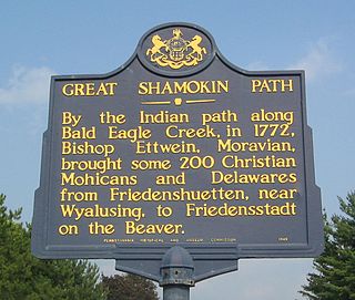
The Great Shamokin Path was a major Native American trail in the U.S. State of Pennsylvania that ran from the native village of Shamokin along the left bank of the West Branch Susquehanna River north and then west to the Great Island. There it left the river and continued further west to Chinklacamoose and finally Kittanning on the Allegheny River.

<span class="mw-page-title-main">Black Moshannon State Park</span> State park in Pennsylvania, United States

Black Moshannon State Park is a 3,480-acre (1,410 ha) Pennsylvania state park in Rush Township, Centre County, Pennsylvania, United States. It surrounds Black Moshannon Lake, formed by a dam on Black Moshannon Creek, which has given its name to the lake and park. The park is just west of the Allegheny Front, 9 miles (14 km) east of Philipsburg on Pennsylvania Route 504, and is largely surrounded by Moshannon State Forest. A bog in the park provides a habitat for diverse wildlife not common in other areas of the state, such as carnivorous plants, orchids, and species normally found farther north. As home to the "largest reconstituted bog in Pennsylvania", it was chosen by the Pennsylvania Department of Conservation and Natural Resources for its "25 Must-see Pennsylvania State Parks" list.

<span class="mw-page-title-main">Sinnemahoning State Park</span> State park in Cameron and Potter counties, Pennsylvania

Sinnemahoning State Park is a 1,910-acre (773 ha) Pennsylvania state park in Grove Township, Cameron County and Wharton Township, Potter County, Pennsylvania, in the United States. The park is surrounded by Elk State Forest and is mountainous with deep valleys. The park is home to the rarely seen elk and bald eagle. Sinnemahoning State Park is on Pennsylvania Route 872, eight miles (13 km) north of the village of Sinnamahoning. In 1958, the park opened under the direction of the Pennsylvania Bureau of Forestry: it became a Pennsylvania State Park in 1962.

<span class="mw-page-title-main">Bucktail State Park Natural Area</span>

Bucktail State Park Natural Area is a 16,433-acre (6,650 ha) Pennsylvania state park in Cameron and Clinton Counties in Pennsylvania in the United States. The park follows Pennsylvania Route 120 for 75 miles (121 km) between Emporium and Lock Haven. Bucktail State Park Natural Area park runs along Sinnemahoning Creek and the West Branch Susquehanna River and also passes through Renovo. The park is named for the Civil War Pennsylvania Bucktails Regiment and is primarily dedicated to wildlife viewing, especially elk.

<span class="mw-page-title-main">Pennsylvania Route 453</span> State highway in Pennsylvania, US

Pennsylvania Route 453 is a 43+34-mile-long (70.4 km) state highway located in Huntingdon, Blair, and Clearfield counties in Pennsylvania. The southern terminus is at U.S. Route 22 (US 22) in Water Street; the northern terminus is at PA 879 in Curwensville.

<span class="mw-page-title-main">Pennsylvania Route 879</span> State highway in Pennsylvania, US

Pennsylvania Route 879 is a 43-mile-long (69 km) state highway located in Clearfield and Centre Counties in Pennsylvania. The western terminus is at U.S. Route 219 (US 219) and PA 729 in Grampian. The eastern terminus is at PA 144 in Snow Shoe Township.

<span class="mw-page-title-main">Pottsville Formation</span>

The Pennsylvanian Pottsville Formation is a mapped bedrock unit in Pennsylvania, western Maryland, West Virginia, Ohio, and Alabama. It is a major ridge-former in the Ridge-and-Valley Appalachians of the eastern United States. The Pottsville Formation is conspicuous at many sites along the Allegheny Front, the eastern escarpment of the Allegheny or Appalachian Plateau.

<span class="mw-page-title-main">Pine Creek Path</span>

The Pine Creek Path was a major Native American trail in the U.S. State of Pennsylvania that ran north along Pine Creek from the West Branch Susquehanna River near Long Island to the headwaters of the Genesee River.

West Decatur is an unincorporated community and census-designated place in Clearfield County, Pennsylvania, United States. As of the 2010 census the population of West Decatur was 533.

<span class="mw-page-title-main">Pennsylvania Route 969</span> State highway in Clearfield County, Pennsylvania, US

Pennsylvania Route 969 is a 10.4-mile-long (16.7 km) state highway located in Clearfield County, Pennsylvania. The western terminus is at U.S. Route 219 in Greenwood Township. The eastern terminus is at PA 453 in Curwensville. The route is known locally as the Lumber City Highway.

<span class="mw-page-title-main">Big Spring (Pennsylvania)</span>

The Big Spring near Luthersburg, Brady Township, Clearfield County, Pennsylvania, was an important camp site and trail hub for the Great Shamokin Path and the Goschgoschink Path.

<span class="mw-page-title-main">Gaps of the Allegheny</span>

The gaps of the Allegheny, meaning gaps in the Allegheny Ridge in west-central Pennsylvania, is a series of escarpment eroding water gaps along the saddle between two higher barrier ridge-lines in the eastern face atop the Allegheny Ridge or Allegheny Front escarpment. The front extends south through Western Maryland and forms much of the border between Virginia and West Virginia, in part explaining the difference in cultures between those two post-Civil War states. While not totally impenetrable to daring and energetic travelers on foot, passing the front outside of the water gaps with even sure footed mules was nearly impossible without navigating terrain where climbing was necessary on slopes even burros would find extremely difficult.

References

  1. Stratigraphic correlation chart of Pennsylvania, T. M. Berg, M. K. McInerney, J. H. Way, and D. B. MacLachlan. 1983; 3rd printing, revised, 1993. 1 sheet, 42" x 58", plus 2 p. addendum.
  2. 1 2 3 4 5 Wall, T.L "Clearfield County- Present and Past" pp. 68–69,76-79,131,144-150 , 1925.
  3. Ashley, G.H., 1940, Geology and mineral resources of the Curwensville quadrangle, Pennsylvania Geological Survey, 4th ser., Atlas 75, 140p.
  4. 1 2 Aldrich, Lewis Cass. "History of Clearfield County" pp 428–434, 1887.
  5. Swoope, Roland Jr. "20th Century History of Clearfield County" p. 261, 1911.
  6. Kashatus, William C. "The Christiana Tragedy" American History October 2002.
  7. 1 2 3 Switala, William J. "The Underground Railroad in Pennsylvania" pp. 30–37, 2001
  8. BLOSS Associates. Draft "Common/Design Language- Greenway System Components/Greenway Form", 2003.