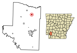
Blevins, Arkansas | |
---|---|
Coordinates: 33°52′27″N93°34′40″W / 33.87417°N 93.57778°W | |
Country | United States |
State | Arkansas |
County | Hempstead |
Area | |
• Total | 0.99 sq mi (2.58 km2) |
• Land | 0.99 sq mi (2.58 km2) |
• Water | 0.00 sq mi (0.00 km2) |
Elevation | 417 ft (127 m) |
Population (2020) | |
• Total | 288 |
• Density | 289.74/sq mi (111.84/km2) |
Time zone | UTC-6 (Central (CST)) |
• Summer (DST) | UTC-5 (CDT) |
ZIP code | 71825 |
Area code | 870 |
FIPS code | 05-07030 |
GNIS feature ID | 2403878 [2] |
Blevins is a city in Hempstead County, Arkansas, United States. The population was 315 at the 2010 census, [3] down from 365 in 2000. It is part of the Hope Micropolitan Statistical Area.
Blevins is located in northeastern Hempstead County. U.S. Route 371 passes through the city as Center Street, leading southeast 15 miles (24 km) to Prescott and northwest 19 miles (31 km) to Nashville. Arkansas Highway 29 is Main Street in Blevins, crossing US 371 in the center of town and leading northeast 18 miles (29 km) to Antoine and south 15 miles (24 km) to Hope, the Hempstead County seat.
According to the United States Census Bureau, the city of Blevins has a total area of 1.0 square mile (2.6 km2), all land. [3]
Census | Pop. | Note | %± |
---|---|---|---|
1930 | 291 | — | |
1940 | 331 | 13.7% | |
1950 | 271 | −18.1% | |
1960 | 198 | −26.9% | |
1970 | 265 | 33.8% | |
1980 | 314 | 18.5% | |
1990 | 253 | −19.4% | |
2000 | 365 | 44.3% | |
2010 | 315 | −13.7% | |
2020 | 288 | −8.6% | |
U.S. Decennial Census [4] 2014 Estimate [5] |
At the 2000 census, [6] there were 365 people, 131 households and 102 families residing in the city. The population density was 365.8 inhabitants per square mile (141.2/km2). There were 152 housing units at an average density of 152.4 per square mile (58.8/km2). The racial makeup of the city was 73.15% White, 14.25% Black or African American, 2.47% Native American, 7.67% from other races, and 2.47% from two or more races. 18.36% of the population were Hispanic or Latino of any race.
There were 131 households, of which 38.2% had children under the age of 18 living with them, 58.8% were married couples living together, 14.5% had a female householder with no husband present, and 22.1% were non-families. 19.8% of all households were made up of individuals, and 11.5% had someone living alone who was 65 years of age or older. The average household size was 2.79 and the average family size was 3.21.
28.2% of the population were under the age of 18, 10.7% from 18 to 24, 22.7% from 25 to 44, 24.4% from 45 to 64, and 14.0% who were 65 years of age or older. The median age was 35 years. For every 100 females, there were 102.8 males. For every 100 females age 18 and over, there were 100.0 males.
The median household income was $31,875 and the median family income was $38,750. Males had a median income of $25,313 versus $18,750 for females. The per capita income for the city was $11,720. About 19.6% of families and 22.1% of the population were below the poverty line, including 25.9% of those under age 18 and 6.9% of those age 65 or over.
Public education for elementary and secondary school students is available from the Blevins School District, which leads to graduation from Blevins High School.
Sevier County is a county located in the U.S. state of Arkansas. As of the 2020 census, the population was 15,839. The county seat is De Queen. Sevier County is Arkansas's 16th county, formed on October 17, 1828, and named for Ambrose Sevier, U.S. Senator from Arkansas. On November 3, 2020, voters in Sevier County, AR approved alcohol sales by a vote of 3,499 to 1,699.
Nevada County is a county located in the southwestern part of the U.S. state of Arkansas. As of the 2020 Census, the population was 8,310, less than half of its peak in 1920. The county seat is Prescott. Nevada County is Arkansas's 63rd county, formed during the Reconstruction era on March 20, 1871, from portions of Hempstead, Ouachita and Columbia counties. It was named after the state of Nevada because of the perceived similarity between their physical shapes; the Arkansas county's shape, inverted, roughly follows the same outline as the state's boundary. It is an alcohol prohibition or dry county.
Howard County is a county located in the U.S. state of Arkansas. As of the 2020 census, the population was 12,785. The county seat is Nashville. Howard County is Arkansas's 74th county, formed on April 17, 1873, and named for James Howard, a state senator. It is a dry county.
Hempstead County is a county located in the U.S. state of Arkansas. As of the 2020 census, the population was 20,065, down from 22,609 at the 2010 census. The county seat is Hope. Hempstead County is Arkansas's fourth county, formed on December 15, 1818, alongside Clark and Pulaski counties. The county is named for Edward Hempstead, a delegate to the U.S. Congress from the Missouri Territory, which included present-day Arkansas at the time. It is an alcohol prohibition or dry county.
Lakeview is a city in Baxter County, Arkansas, United States. The population was 741 at the 2010 census.
Thornton is a city in Calhoun County, Arkansas, United States. The population was 407 as of the 2010 census, down from 517 in 2000. It is part of the Camden, Arkansas micropolitan area.
Emmet is a city in Nevada and Hempstead counties in the U.S. state of Arkansas. It is located at the intersection of U.S. Highway 67 and Arkansas Highway 299 in the Arkansas Timberlands region of southwest Arkansas. It is part of the larger Ark-La-Tex tri-state region. As of the 2010 census, the population of Emmet was 518.
Fulton is a town in Hempstead County, Arkansas, United States. The population was 201 at the 2010 census. It is part of the Hope Micropolitan Statistical Area. The community is named after steamboat inventor Robert Fulton.
McCaskill is a town in Hempstead County, Arkansas, United States. The population was 96 at the 2010 census. It is part of the Hope Micropolitan Statistical Area.
McNab is a town in Hempstead County, Arkansas, United States. The population was 68 at the 2010 census, up from 37 in 2000. It is part of the Hope Micropolitan Statistical Area.
Oakhaven is a town in Hempstead County, Arkansas, United States. The population was 63 at the 2010 census. It is part of the Hope Micropolitan Statistical Area.
Ozan is a town in Hempstead County, Arkansas, United States. The population was 85 at the 2010 census. It is part of the Hope Micropolitan Statistical Area.
Patmos is a town in Hempstead County, Arkansas, United States. The population was 64 at the 2010 census. It bears the same name as the Greek island of Patmos.
Perrytown is a town in Hempstead County, Arkansas, United States. The population was 272 at the 2010 census. It is part of the Hope Micropolitan Statistical Area and was founded in 1959 by local entrepreneur Perry Campbell.
Washington is a city in Ozan Township, Hempstead County, Arkansas, United States. The population was 180 at the 2010 census, up from 148 in 2000. It is part of the Hope Micropolitan Statistical Area. The city is home to Historic Washington State Park.
Lewisville is a city in Lafayette County, Arkansas, United States. The population was 1,280 at the 2010 census. It is the county seat of Lafayette County.
Ratcliff is a city in Logan County, Arkansas, United States. The population was 202 at the 2010 census.
Wrightsville is a city in Pulaski County, Arkansas, United States. Its population was 1,542 at the 2020 census. It is part of the Little Rock–North Little Rock–Conway Metropolitan Statistical Area. Located on Highway 365, Wrightsville existed as an unincorporated community for more than a century before it was incorporated late in the 20th century. Since 1981, it has been home to a major Arkansas Department of Corrections facility, which is the principal employer.
Garden City Park is a hamlet and census-designated place (CDP) located in the Town of North Hempstead in Nassau County, New York, on Long Island. It's a suburb of New York City, located approximately 20 miles (32 km) from Midtown Manhattan. The population was 7,806 at the 2010 census.
Uintah is a city in Weber County, Utah, United States. The population was 1,322 at the 2010 census. It is part of the Ogden–Clearfield, Utah Metropolitan Statistical Area. Although Uintah was a town in 2000, it has since been classified as a fifth-class city by state law.