Bonito, Bahia

Last updated
Bonito
Municipality
Bandeira Bonito - BA.svg
Brasao de Bonito BA.png
Bahia Municip Bonito.svg
Location of Bonito in Bahia
Bonito, Bahia
Brazil location map.svg
Red pog.svg
Bonito
Location in Brazil
Coordinates: 11°57′57″S41°16′01″W / 11.96583°S 41.26694°W / -11.96583; -41.26694
CountryFlag of Brazil.svg  Brazil
Region Nordeste
State Bahia
Territory of Identity Chapada Diamantina
Political Emancipation (1989-06-13) June 13, 1989 (age 35)
Government
  Type Mayor–council government
  BodyBonito City Council
  MayorEdivam José Cedro De Souza
Area
[1]
  Total
641.229 km2 (247.580 sq mi)
Elevation
990 m (3,250 ft)
Population
 (2020 [2] )
  Total
16,884
  Density26/km2 (68/sq mi)
Time zone UTC−3 (BRT)
Area code 75

Bonito is a municipality in the state of Bahia in the North-East region of Brazil. [3] [4] [5] [6] It is the fifth municipality in the country with the highest proportion of Quilombola population, with 50.2% of its inhabitants being part of this group. [7]

Contents

History

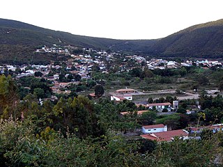
The municipality of Bonito, located in the Chapada Diamantina region, originated in the late 19th century. At the time, a road connected neighboring towns, and the area where the city now stands became a resting point for travelers, thanks to the presence of a large tree that provided shade. This place, which initially served as a shelter, was gradually inhabited by immigrants, forming a small community. [8]

At the beginning of the 20th century, the town consisted of just a few residences. The holding of a regular fair, organized by the residents, marked the local economic development, reducing the dependence on travel to neighboring towns. Over time, the town continued to grow, attracting new residents from other regions. [8]

Agriculture was a key factor in the development of the area, especially coffee cultivation. The introduction of modern cultivation techniques and adaptation to local conditions allowed the consolidation of a promising agricultural activity. Financing projects and technical analyses ended up favoring the expansion of plantations, which contributed significantly to economic and population growth. [8]

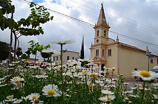
Religion also played an important role in the formation of the community. Masses and religious celebrations marked the strengthening of social ties, culminating in the construction of a chapel with the collective support of the inhabitants. [8]

It was created as a district with the name of Bonito (former village), by State Law No. 4,031, of May 14, 1982, and integrated into the municipality of Utinga.

It was elevated to the category of municipality with its current name, by State Law No. 5,021, of June 13, 1989, separated from the municipality of Utinga. It was installed on January 1, 1990, with the inauguration of the first councilors and the first mayor, with his deputy, democratically elected. [9]

Geography

It is located at Latitude 11º58'10" South and Longitude 41º15'57" West, at an elevation of 990 meters.

Communities

NameAreaCategoryRef.
Bonito Urban City and Municipal Seat [10]
Catuaba Semi-urban Town and Municipal District [10]
Cabeceira do Brejo Semi-urban Town and Municipal District [10]
Baixa do Cheiro Rural Village [10]
Guarani Rural Village [10]
Guarani II Rural Village [10]
Botafogo Rural Village [10]
Baixa Vistosa Rural Village [10]
Gramiá Rural Village [10]
Mata Florença Rural Village [10]
Morrinhos Rural Village [10]
Lagoa do Alívio Rural Village [10]
Gitirana Rural Village [10]
Quixaba Rural Village [10]
Catuabinha Rural Village [10]
Agropeva Rural Village [10]

Hydrography

Image of Cacique Waterfall, located near the village of Botafogo, Bonito. Cachoeira da Cacique.jpg
Image of Cacique Waterfall, located near the village of Botafogo, Bonito.

The municipality is located in the Paraguaçu River basin and is bathed by the Bonito, Tijuco, das Lajes and Sohen Rivers. [11] [12] [13] It is also rich in waterfalls, with highlights including the Soltinha Waterfall and the Cacique Waterfall, tourist attractions in the region.

Political-Administrative Organization

The Municipality of Bonito has a political-administrative structure composed of the Executive Branch, headed by a Mayor elected by universal suffrage, who is directly assisted by municipal secretaries appointed by him, and the Legislative Branch, institutionalized by the City Council of Bonito, a collegiate body representing the citizens that is composed of 11 councilors also elected by universal suffrage. [14]

Municipal authorities of Bonito

Municipal Executive

City hall
PositionIncumbentPartyTermRef.
Mayor Edivam José Cedro De Souza PSD (2025–2028) [15]
Deputy Mayor Ueriton de Sousa Primo PP (2025–2028) [15]
Treasurer Gilmar de Sá Teles Silva(2025–present) [16]
Departments
DepartmentSecretary/DirectorPartyTermRef.
HealthMárcio Fagner Souto de Barros PSD (2025–present) [17]
EducationReinan Cedro de Oliveira PSD (2025–present) [18]
Urban and Rural DevelopmentTo be defined
Social WelfareSidalva Alves dos Santos PSD (2025–present) [16]
Culture, Sports and TourismAlex Sandro Ferreira de Lima PP (2025–present) [16]
AgricultureAlek Sandro Santana Beu(2025–present) [16]
Administration, Planning and FinanceGeovanilson José de Souza.(2025–present) [16]
EnvironmentAndré Torres(2025–present) [19]

City Council

Composition of the Bonito City Council after the 2024 Elections: [20]

Government:
.mw-parser-output .legend{page-break-inside:avoid;break-inside:avoid-column}.mw-parser-output .legend-color{display:inline-block;min-width:1.25em;height:1.25em;line-height:1.25;margin:1px 0;text-align:center;border:1px solid black;background-color:transparent;color:black}.mw-parser-output .legend-text{}
PSD: 3 seats
PP: 4 seats
PSB: 2 seats
Opposition:
PDT: 2 seats Bonito-BA Camara Municipal 2025.svg
Government:
  PSD: 3 seats
  PP: 4 seats
  PSB: 2 seats
Opposition:
  PDT: 2 seats

See also

Related Research Articles

<span class="mw-page-title-main">Ituaçu</span> Municipality in Bahia, Brazil

Ituaçu is a city in the Chapada Diamantina region of Bahia, Brazil. The city is 530 km from Salvador, the capital city of Bahia. It is the birthplace of singer Moraes Moreira, while another singer Gilberto Gil lived there from 2 months old. The climate is temperate, falling to 12 °C during the winter. Its estimated population in 2020 is 19,030.

<span class="mw-page-title-main">Morro do Chapéu</span> Municipality of Bahia State, Brazil

Morro do Chapéu is a municipality in the Brazilian state of Bahia, 386 km northwest of its capital, Salvador, 1012 meters above the sea level, because of which it is one of the coolest towns in Bahia, with temperatures occasionally falling below 10 °C in the winter. Its estimated population in 2020 is 35,440.

<span class="mw-page-title-main">Bonito, Pernambuco</span> City in Pernambuco, Brazil

Bonito (Beautiful) is a city in northeastern Brazil, in the State of Pernambuco. It lies in the mesoregion of Agreste of Pernambuco. Has 399.5 sq/km of total area.

<span class="mw-page-title-main">Iraquara</span> Municipality of Bahia State, Brazil

Iraquara is a municipality in the state of Bahia in the North-East region of Brazil.

Jussara, Bahia is a municipality in the state of Bahia in the North-East region of Brazil.

Presidente Dutra is a municipality in the state of Bahia in the North-East region of Brazil.

São Gabriel, Bahia is a municipality in the state of Bahia in the North-East region of Brazil.

<span class="mw-page-title-main">São José do Jacuípe</span> Municipality in Nordeste, Brazil

São José do Jacuípe is a municipality in the state of Bahia in the North-East region of Brazil.

<span class="mw-page-title-main">Macaúbas</span> Municipality in Nordeste, Brazil

Macaúbas is a municipality in the state of Bahia in the North-East region of Brazil. Its population in 2020 was 50,161 inhabitants. The municipality covers an area of 3039 km2. It lies in the call Physiographic Zone of the Serra Geral, the Chapada Diamantina Southern microregion.

Mucugê is a municipality in the state of Bahia, in the North-East region of Brazil. It is close to the Chapada da Diamantina National Park.

<span class="mw-page-title-main">Palmeiras, Bahia</span> Municipality in Nordeste, Brazil

Palmeiras is a municipality in the state of Bahia in the North-East region of Brazil.

Utinga is a municipality in the state of Bahia in the North-East region of Brazil.

Nova Soure is a municipality in the state of Bahia in the North-East region of Brazil.

São Domingos is a municipality in the state of Bahia in the North-East region of Brazil.

Teofilândia is a municipality in the state of Bahia in the North-East region of Brazil.

Valente is a municipality in the state of Bahia in the North-East region of Brazil.

Pilar, Paraíba is a municipality in the state of Paraíba in the Northeast Region of Brazil. It had a population of about 12,311 according to the 2022 census, and an estimated population of 12,801 in 2024.

Rio Bonito do Iguaçu is a municipality in the state of Paraná in the Southern Region of Brazil.

Porto Rico, Paraná is a municipality in the state of Paraná in the Southern Region of Brazil.

Pavussu is a municipality in the state of Piauí in the Northeast region of Brazil.

References

  1. "IBGE | Portal do IBGE | IBGE". www.ibge.gov.br. Retrieved 2025-01-12.
  2. IBGE 2020
  3. "Divisão Territorial do Brasil" (in Portuguese). Divisão Territorial do Brasil e Limites Territoriais, Instituto Brasileiro de Geografia e Estatística (IBGE). July 1, 2008. Retrieved December 17, 2009.
  4. "Estimativas da população para 1º de julho de 2009" (PDF) (in Portuguese). Estimativas de População, Instituto Brasileiro de Geografia e Estatística (IBGE). August 14, 2009. Retrieved December 17, 2009.
  5. "Ranking decrescente do IDH-M dos municípios do Brasil" (in Portuguese). Atlas do Desenvolvimento Humano, Programa das Nações Unidas para o Desenvolvimento (PNUD). 2000. Archived from the original on October 3, 2009. Retrieved December 17, 2009.
  6. "Produto Interno Bruto dos Municípios 2002-2005" (PDF) (in Portuguese). Instituto Brasileiro de Geografia e Estatística (IBGE). December 19, 2007. Archived from the original (PDF) on October 2, 2008. Retrieved December 17, 2009.
  7. "Bonito, na Bahia, é uma das cinco cidades do Brasil onde mais da metade da população é formada por quilombolas; conheça | Bahia". G1 (in Brazilian Portuguese). 2023-07-27. Retrieved 2025-01-11.
  8. 1 2 3 4 "História de Bonito Bahia" . Retrieved 2025-01-11.
  9. "Histórico do município (IBGE)". www.ibge.gov.br. Retrieved 2018-10-31.
  10. 1 2 3 4 5 6 7 8 9 10 11 12 13 14 15 16 "Mapa Descritivo Bonito-BA" (PDF). Superintendência de Estudos Econômicos e Sociais da Bahia (in Brazilian Portuguese). 2010. Retrieved 11 January 2025.
  11. "Bonito-BA" (PDF). Instituto Brasileiro de Geografia e Estatística (in Brazilian Portuguese). Retrieved 11 January 2025.
  12. "DIAGNÓSTICO DO MUNICÍPIO DE BONITO" (PDF). Serviço Geológico do Brasil. October 2005. Retrieved 11 January 2025.
  13. "Bonito Chapada Diamantina, Bahia, Cirquito Chapada Norte, Guia de turismo de Bonito :: Ibicoara Chapada Diamantina". www.ibicoarachapadadiamantina.com.br. Retrieved 2025-01-12.
  14. MEIRELLES, Hely Lopes. Direito municipal brasileiro. 18. ed. São Paulo: Malheiros, 2017.
  15. 1 2 "Prefeito de Bonito (BA) toma posse nesta quarta (1º); veja lista de vereadores eleitos | Eleições 2024 na Bahia". G1 (in Brazilian Portuguese). 2024-12-31. Retrieved 2025-01-11.
  16. 1 2 3 4 5 "Diário Oficial de Bonito". Diário Oficial. Retrieved 11 January 2025.
  17. "Diário Oficial" . Retrieved 12 January 2025.
  18. "DECRETO Nº 012/2025" (PDF). 13 January 2025. Retrieved 15 January 2025.
  19. "DECRETO Nº 015/2025" (PDF). 15 January 2025. Retrieved 15 January 2025.
  20. "Apuração das Eleições em Bonito (BA) | Eleições 2024". G1 (in Brazilian Portuguese). Retrieved 2025-01-11.

11°57′57″S41°16′01″W / 11.96583°S 41.26694°W / -11.96583; -41.26694