Boothwyn, Pennsylvania | |
---|---|
Coordinates: 39°50′06″N75°26′40″W / 39.83500°N 75.44444°W | |
Country | United States |
State | Pennsylvania |
County | Delaware |
Township | Upper Chichester |
Area | |
• Total | 1.25 sq mi (3.23 km2) |
• Land | 1.25 sq mi (3.23 km2) |
• Water | 0.00 sq mi (0.00 km2) |
Elevation | 98 ft (30 m) |
Population | |
• Total | 4,968 |
• Density | 3,983.96/sq mi (1,537.60/km2) |
Time zone | UTC-5 (EST) |
• Summer (DST) | UTC-4 (EDT) |
ZIP code | 19061 |
Area code(s) | 610 and 484 |
FIPS code | 42-07616 |
Boothwyn is a census-designated place (CDP) in Delaware County, Pennsylvania, United States. The population was 4,933 at the 2010 census, [3] down from 5,206 at the 2000 census. The census estimation for population circa 2019 is 6,115.
The Chichester Friends Meeting, which was organized in 1682, with the current building constructed in 1769, is listed on the National Register of Historic Places. [4] Bill Haley, who pioneered Rock n' Roll with Bill Haley & His Comets, was a long-time resident of Boothwyn.
Local Favorite and Pennsylvania Amish Market "Booth's Corner" is within the Bounds of Boothwyn, built at the corner of the old land holdings of Edwin Booth, who gives the building and Boothwyn its name.
Boothwyn is located in southwestern Delaware County at 39°50′6″N75°26′40″W / 39.83500°N 75.44444°W (39.835115, -75.444507), [5] in the southern part of Upper Chichester Township. The CDP contains the unincorporated communities of Boothwyn (southern part of the CDP) and Gardendale (northern part). Boothwyn is 6 miles (10 km) southwest of Chester and 10 miles (16 km) northeast of Wilmington, Delaware.
According to the United States Census Bureau, the CDP has a total area of 1.25 square miles (3.23 km2), all land. [3]
The Boothwyn, Reliance, and Ogden fire companies are located in Boothwyn.
Boothwyn is a part of Chichester School District. Children within the area usually attend Boothwyn Elementary School or Hilltop School (Grades K-4), Chichester Middle School (Grades 5-8), or Chichester High School (Grades 9-12).
Holy Family Regional Catholic School in Aston, of the Roman Catholic Archdiocese of Philadelphia, is the area Catholic school. It formed in 2012 from a merger of Holy Savior-St. John Fisher Elementary School in Linwood and St. Joseph Catholic School in Aston. [6] Holy Savior School opened in 1917, and changed its name after St. John Fisher Church was established in Boothwyn in 1971 as the school at that time became the parish school of St. John Fisher. [7]
As of the census [8] of 2000, there were 5,206 people, 2,047 households, and 1,367 families residing in the CDP. The population density was 4,236.1 inhabitants per square mile (1,635.6/km2). There were 2,126 housing units at an average density of 1,729.9 per square mile (667.9/km2). The racial makeup of the CDP was 80.70% White, 6.13% African American, 0.10% Native American, 1.67% Asian, 0.02% Pacific Islander, 0.40% from other races, and 0.98% from two or more races. Hispanic or Latino of any race were 10.11% of the population.
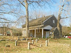
There were 2,047 households, out of which 29.0% had children under the age of 18 living with them, 49.6% were married couples living together, 12.7% had a female householder with no husband present, and 33.2% were non-families. 26.4% of all households were made up of individuals, and 9.2% had someone living alone who was 65 years of age or older. The average household size was 2.54 and the average family size was 3.12.
In the CDP, the population was spread out, with 22.7% under the age of 18, 9.0% from 18 to 24, 31.8% from 25 to 44, 23.7% from 45 to 64, and 12.8% who were 65 years of age or older. The median age was 37 years. For every 100 females, there were 91.6 males. For every 100 females age 18 and over, there were 89.3 males.
The median income for a household in the CDP was $46,433, and the median income for a family was $60,096. Males had a median income of $41,793 versus $29,962 for females. The per capita income for the CDP was $23,811. About 6.7% of families and 6.2% of the population were below the poverty line, including 9.2% of those under age 18 and 7.1% of those age 65 or over.
Census | Pop. | Note | %± |
---|---|---|---|
2000 | 5,206 | — | |
2010 | 4,933 | −5.2% | |
2020 | 4,968 | 0.7% | |
Sources: [9] [8] [10] [2] |
First Mesa is a census-designated place (CDP) in Navajo County, Arizona, United States, on the Hopi Reservation. As of the 2010 census, the CDP population was 1,555, spread among three Hopi villages atop the 5,700-foot mesa: Hano, Sitsomovi, and Waalpi.
Highland Acres is a census-designated place (CDP) in Kent County, Delaware, United States. It is part of the Dover, Delaware Metropolitan Statistical Area. The population was 3,459 at the 2010 census.
Kent Acres is a census-designated place (CDP) in Kent County, Delaware, United States. It is part of the Dover, Delaware Metropolitan Statistical Area. The population was 1,890 at the 2010 census.
Riverview is a census-designated place (CDP) in Kent County, Delaware, United States. It is part of the Dover, Delaware Metropolitan Statistical Area. The population was 2,456 at the 2010 census.
Rodney Village is a census-designated place (CDP) in Kent County, Delaware, United States. It is part of the Dover, Delaware Metropolitan Statistical Area. The population was 1,487 at the 2010 census.
Woodside East is a census-designated place (CDP) in Kent County, Delaware, United States. It is part of the Dover, Delaware Metropolitan Statistical Area. The population was 2,316 at the 2010 census.
Brookside is a census-designated place (CDP) in New Castle County, Delaware, United States. The population was 14,353 at the 2010 census.
Edgemoor is a census-designated place in New Castle County, Delaware, United States. The population was 5,677 at the 2010 census.
Glasgow is a census-designated place (CDP) in New Castle County, Delaware, United States. The population was 15,288 at the 2020 census.
North Star is a census-designated place (CDP) in New Castle County, Delaware, United States. The population was 7,980 at the 2010 census.
Rising Sun-Lebanon is a census-designated place (CDP) in Kent County, Delaware, United States. It is part of the Dover, Delaware Metropolitan Statistical Area. The population was 3,391 at the 2010 census.
Broomall is a census-designated place (CDP) in Marple Township, Delaware County, Pennsylvania, United States. The population was 10,789 at the 2010 census.
Linwood is a census-designated place (CDP) in Delaware County, Pennsylvania, United States. The population was 3,281 at the 2010 census.
Lower Chichester Township is a township in Delaware County, Pennsylvania, United States. The population was 3,469 at the 2010 census. It contains the census designated place of Linwood.
Marcus Hook is a borough in Delaware County, Pennsylvania, United States. The population was 2,397 at the 2010 census. The current mayor is Gene Taylor. The borough calls itself "The Cornerstone of Pennsylvania". The 2005 film One Last Thing... was set and partially filmed in Marcus Hook.
Trainer is a borough in Delaware County, Pennsylvania, United States. The population was 1,828 at the 2010 census, down from 1,901 at the 2000 census. The borough was named after David Trainer, a wealthy textile manufacturer.
Upper Chichester Township is a civil township in Delaware County, Pennsylvania, United States. The population was 16,738 at the 2010 census.
Village Green-Green Ridge is a census-designated place (CDP) in Delaware County, Pennsylvania, United States. The population was 7,822 at the 2010 census, down from 8,279 at the 2000 census.
Mountain Top is an unincorporated area and census-designated place (CDP) in Luzerne County, Pennsylvania, United States. As of the 2010 census, its population was 10,982.
Chichester, formerly New Chichester in reference to the English city, is a region in Delaware County, Pennsylvania, United States. It includes the townships of Upper Chichester and Lower Chichester, and the boroughs of Marcus Hook, and Trainer. Other communities included in the region are Linwood, Boothwyn, Ogden, and Twin Oaks.