Borča (Serbian Cyrillic : Борча, pronounced [bɔ̂ːrt͡ʃa] ) is an urban settlement of the municipality of Palilula, Belgrade, Serbia. It is located in the left-bank part of the municipality, separated by the Danube from the rest of the city. As of 2011 [update] , it has a population of 46,086 inhabitants.
Borča is located just 8 km (5.0 mi) north of the downtown Belgrade, in the Banat section of the municipality of Palilula, at an altitude of 78 m (256 ft). It stretches between the Zrenjaninski put road (which connects Belgrade to the town of Zrenjanin in Vojvodina) and the slow streams of Pretok, Sebeš and Vizelj, which flows through the middle of the marshy area of Pančevački Rit, the northern part of the municipality of Palilula. [3] [4]
As Borča developed, it stretched along the Zrenjaninski put to the south (Krnjača's neighborhood of Dunavski Venac) and to the north (suburban settlement of Padinska Skela). [5]
Earliest remains in the vicinity of modern settlement of Borča are from the Bronze and Iron Age, but the medallions, figurines and coins from the 3rd and 4th century BC are also found. Because of the marshy area, not much is preserved, but the remains which confirm presence of the Sarmatians (including Iazyges) and Romans were found.
Borča was mentioned for the first time in 1375 under name Barcsa (or Bercse). Settlement was under administration of the Kingdom of Hungary, although its name imply possible Slavic root (Name Barcsa possibly derived from Slavic word "bara" meaning "swamp" in English, indicating the settlement's position in the swampy area of Pančevački Rit). In 1537 it was captured by the Ottomans, included into the Sanjak of Smederevo and granted the waqf status. Already in 1567 Borča was predominantly settled by the Serbs when famous Jazak Gospel was written in it. During the Habsburg-Ottoman wars, Borča became center of the Ottoman border zone and was heavily fortified (Porača fort) after the Treaty of Karlowitz but was still conquered by the Habsburgs in 1717 and by the Treaty of Passarowitz in 1718 was formally handed over to the Habsburg Monarchy.
After the Treaty of Belgrade in 1739 Habsburg Monarchy obliged to tear down the fortifications, but due to the outbreak of the plague in 1743 the entire village of Borča was burned to the ground. The new settlement emerged around the sentry post of Stara Borča (Alt Borcsa) in 1794 which became center of a municipality as part of the Banat Krajina, a section of the Habsburg Military Frontier.
In 1848-1849, Borča belonged to the Serbian Vojvodina, a Serb autonomous region within Habsburg Monarchy, but in 1849 it was again placed under administration of the Military Frontier. After transformation of Habsburg Monarchy into the Austria-Hungary in 1867 and abolition of the Military Frontier on 27 June 1873 Borča became part of the Hungarian half of the monarchy, as part of the Pančevo district within Torontál comitatus, seated in modern Zrenjanin. In 1910, ethnic Serbs were in an absolute majority in Borča. [6] Other ethnic groups in the settlement included Germans, Hungarians and Romanians. Borča was shortly taken by the Serbian army during World War I (6 September - 14 October 1914).
As Pančevački Rit is a floodplain, during extremely high levels of the Danube (especially in 1826, 1888 and 1924), entire area and settlements in it were completely flooded turning the marsh into a large lake. It was recorded that during the floods of 1924, rescue ships had to maneuver between the telephone poles and that dead were buried from the boats. In 1929-1933 an 89 kilometer-long embankment was built which protected Borča from further floodings. At the same time, road and railway connecting Borča to Belgrade were also built.
After the collapse of Austria-Hungary in 1918, Borča became part of the Kingdom of the Serbs, Croats and Slovenes (future Yugoslavia), being taken by the Serbian army on 9 November 1918. From 1918 to 1922, it was part of the Banat county, from 1922 to 1929 part of the Belgrade oblast, and from 1929 to 1941 part of the Belgrade City Administration (the District of Pančevo). Between 1941 and 1944 it was occupied by German troops and included into German-ruled autonomous region of Banat, which was a part of Serbia.
In 1949 the municipality was disbanded and the entire area of Pančevački Rit became IX Raion of Belgrade. Borča got its own municipality again on 30 May 1952 but in 1955 with municipalities of Ovča, Krnjača and Padinska Skela merged into one named Krnjača. In turn, this municipality was annexed to the Belgrade's municipality of Palilula in 1965.
When construction of the Pupin Bridge was coming to an end in 2014, building of a massive industrial park by the Chinese investors at the Borča side of the bridge was announced. This was confirmed by the government in 2020 and 2021, when the project was called Mihajlo Pupin Industrial Park, and was labeled "European Shenzhen". In March 2023 construction of the access infrastructure to the future construction site was announced. The park will cover 483.5 ha (1,195 acres), divided in three sections - commercial center, industrial park and high-tech park. The entire complex will be patterned after Xuzhou, near Shanghai. Estimated length of the construction is 19 years. [7] [8]
In December 2021, city announced restoration of the riverine public transportation, which was discontinued decades ago. One of the first two proposed lines should be Borča-Ada Huja. In the same month, construction of the pier at Ada Huja began. [9] [10] New mayor Aleksandar Šapić, however, stated in July 2022 that the project will not be pursued further, calling it too expensive and "pointless". [11] [12]
Year | Pop. | ±% p.a. |
---|---|---|
1910 | 1,910 | — |
1921 | 1,860 | −0.24% |
1931 | 1,724 | −0.76% |
1948 | 3,532 | +4.31% |
1953 | 3,384 | −0.85% |
1961 | 4,330 | +3.13% |
1971 | 9,487 | +8.16% |
1981 | 18,549 | +6.93% |
1991 | 26,895 | +3.79% |
2002 | 35,150 | +2.46% |
2011 | 46,086 | +3.06% |
2022 | 51,862 | +1.08% |
Source: [13] [14] |
In 1727, 39 households were recorded in the settlement. In 1843 it had 675 inhabitants while in 1859 there were 124 households. In 1910, by the last census in Austria-Hungary in had a population of 1,535. Since the 1960s Borča began a massive development with rapid population growth having a population of 46,086 by the official census in 2011.
Following the official data, Borča is the largest single suburb of Belgrade. However, unofficial estimates put Kaluđerica in first place. Borča is statistically classified as an urban settlement.
Ethnic structure of Borča (census 2002):
As one of the largest suburbs of Belgrade and a large settlement in its own right, Borča developed several sub-neighborhoods of its own. Officially, after the 1981 census, Borča is divided into three "local communities" (mesna zajednica), sub-municipal administrative units: Stara Borča (formerly Borča I, 1991-2002), Borča Greda (formerly Borča II) and Nova Borča (formerly Borča III). Most of Borča is grouped into centers (Centar I to V), which are sometimes referred to as Borča I to V (Centar I = Borča I, etc.).
Local community of Stara Borča (Old Borča) occupies the entire southern section of the settlement. It extends on both sides of Zrenjaninski put and comprises most diverse neighborhoods of Borča: the original, oldest section in the south-west, those closest to Belgrade, easternmost sections which extends to Ovča and the south-western extension in the direction of the Danube. It had a population of 7,928 in 1991, [15] 13,624 in 2002 [16] and 20,188 in 2011. [17]
Local community of Nova Borča (New Borča) occupies the east-central corner of Borča. Unlike Stara Borča and Borča Greda, it comprises only one sub-neighborhood, Centar III. It had a population of 9,640 in 1991, [15] 14,875 in 2002 [16] and 7,298 in 2011. [17]
Local community of Borča Greda occupies the entire northern section of the settlement, extending on both sides of Zrenjaninski put. The fastest growing sections of Borča, like Pretok or Mali Zbeg, are located in this local community, so it more than doubled its population between the 2002 and 2011 censuses: 9,327 in 1991, [15] 8,087 in 2002 [16] and 18,600 in 2011. [17]
There are only few parks in Borča, and they are small. One, called Mali park (Small Park, formerly Park Sonje Marinković), is located in Borča I.
Another, called Park Centar 3 (formerly Park JNA) is located along the curve of the Ratnih vojnih invalida Street, at the Borča 3 roundabout of the bus lines 85, 95, 96 and 105L. It covers an area of 3,354 m2 (36,100 sq ft) and was renovated in November 2017. [21]
This article deals with the system of transport in Belgrade, both public and private.
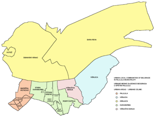
Palilula is a municipality of the city of Belgrade. It has the largest area of all municipalities of Belgrade. The core of Palilula is close to the center of the city, but the municipality also includes sparsely populated land left of the Danube.
Ovča is a suburban settlement of Belgrade, the capital of Serbia. It is located to the northeast of the city, in the municipality of Palilula.
Mika Alas is an urban neighborhood of Belgrade, the capital of Serbia. It is located in Belgrade's municipality of Palilula.
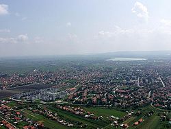
Krnjača is an urban neighborhood of Belgrade, the capital of Serbia. It is located in Belgrade's municipality of Palilula.
Pančevački Rit is a small geographical area in south-western Banat, Serbia. It is situated between the rivers Danube and Tamiš, in Belgrade's municipality of Palilula.
Dunavski Venac is an urban neighborhood of Belgrade, the capital of Serbia. It is located in Belgrade's municipality of Palilula, geographically located in Banat.
Reva is an urban neighborhood of Belgrade, the capital of Serbia. It is a sub-neighborhood of Krnjača and is located in Belgrade's municipality of Palilula. According to the 2011 census, it had a population of 2,522.
Glogonjski Rit is a suburban settlement of Belgrade, the capital of Serbia. It is located in the Belgrade's municipality of Palilula.
Kovilovo is a suburban settlement of Belgrade, the capital of Serbia. It is located in the Belgrade's municipality of Palilula.
Sebeš is a river, bog and a suburban settlement of Belgrade, the capital of Serbia. All three are located in the Belgrade's municipality of Palilula.
Padinska Skela, or colloquially Padinjak (Падињак), is a suburban settlement of Belgrade, the capital of Serbia. It is located in the Belgrade's municipality of Palilula.
Čaplja is a projected river island (ada) in Serbia, on the left bank of the Danube. According to the General Urbanistic Plan (GUP) of Belgrade, it will be formed in Belgrade's municipality of Palilula.
Marinkova Bara is an urban neighborhood of Belgrade, the capital of Serbia. It is located in the municipality of Voždovac.
Konjarnik is an urban neighborhood of Belgrade, the capital of Serbia. It is divided between Belgrade's municipalities of Voždovac and Zvezdara. As a large neighborhood, it has several sub-neighborhoods of its own, including Denkova Bašta, Učiteljsko Naselje and Rudo.
BG Voz is an urban rail system that serves the city of Belgrade, Serbia. It is operated by the public transit corporation GSP Belgrade and is a part of the integrated BusPlus system.
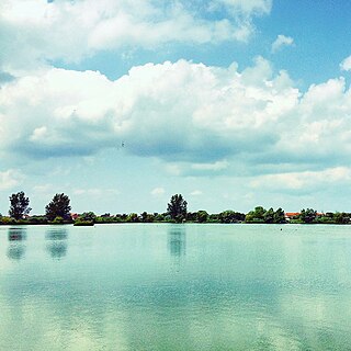
Veliko Blato is a lake in Krnjača, an urban neighborhood of Belgrade, Serbia. It is located in the municipality of Palilula.
The Vizelj is a short channeled river in north-central Serbia, the left tributary to the Danube. During its entire flow it runs through the suburban section of Belgrade, on the territory of municipality of Palilula.
Beljarica is a wetland in the Danube valley in Belgrade, the capital of Serbia. Since 2013, it is in the process of becoming protected area. Due to the abundant wildlife and undisturbed nature, though being close to downtown Belgrade, it has been nicknamed "Belgrade's Amazonia". With Gornje Podunavlje and Kovilj-Petrovaradin Marshes, both of which have already been declared special nature reserves, Beljarica is among the largest flood zones in Serbia.
{{cite web}}
: CS1 maint: archived copy as title (link)