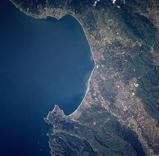
Monterey Bay is a bay of the Pacific Ocean located on the coast of the U.S. state of California. The bay is south of the major cities of San Francisco and San Jose. The county-seat city of Santa Cruz is located at the north end of the bay. The city of Monterey is on the Monterey Peninsula at the south end. The Monterey Bay Area is a local colloquialism sometimes used to describe the whole of the Central Coast communities of Santa Cruz and Monterey counties.

Uvas Canyon County Park is a 1,147-acre (464 ha) natural park located in upper Uvas Canyon on the eastern side of the Santa Cruz Mountains, west of Morgan Hill, California. The park has several small waterfalls, some of which flow perennially, that feed into tributaries confluent with Uvas Creek. The park is part of the Santa Clara County Parks System, and facilitates picnics, hiking and overnight camping. It is one of the few parks in the area that allows dogs in the campgrounds.
Hatton Canyon is a canyon in Carmel Valley, California, USA, preserved for urban open space as a state park property. The canyon harbors Monterey pines and 10 acres (4.0 ha) of wetland. For decades it was eyed as a possible site for a 2.8-mile-long (4.5 km) freeway to relieve traffic on a parallel stretch of Highway 1. However homeowners and environmentalists opposed the plan since its proposal in 1952, ultimately gaining major political support in the 1990s. In 2002 Governor Gray Davis signed legislation that officially transferred the property from CalTrans to California State Parks. It is currently accessible to the public at Carmel Valley Road via a dirt trail at the mouth of Carmel Valley. Plans to pave the trail to allow bicycle access were set aside in 2009 due to concerns of some neighbors.
Babine Lake Marine Provincial Park is a provincial park in British Columbia, Canada. The park was established by Order-in-Council in 1993, comprising two sites at Pendleton Bay totalling 36.9 hectares. Another was established in the same year at Smithers Landing, comprising approximately 157.8 hectares. Three more sites were added in 2001, Hook (Deep) Bay, Pierre Creek, Pinkut Creek and Sandpoint. All sites combined comprise approximately 492 hectares.
High Gate is an unincorporated community in eastern Maries County, Missouri, United States. It is approximately fourteen miles east of Vienna.

Pulga is an unincorporated community in Butte County, California. It is located along the west slope of the Feather River canyon, at an elevation of 1398 feet. A variant name for the community is Big Bar. Other nearby communities include Mayaro, Poe and Parkhill. The town hosts a Caltrans highway maintenance station along State Route 70 (SR70). The place is at the mouth of the Flea Valley Creek, which gives rise to the toponym.
Waikejiao Island(simplified Chinese: 外磕脚; traditional Chinese: 外磕腳; pinyin: Wàikējiǎo),(33°0'54"N, 121°38'24"E) is a small sand island located in the East China Sea, adjacent to Jiangsu. Macaiheng is close by.
Locust Manor is a neighborhood in the New York City borough of Queens. It is bordered on the north by Baisley Boulevard to Irwin Place to Roe Road to 120th Avenue, on the east by the tracks of the Long Island Rail Road to 121st Avenue to Farmers Boulevard, on the south by North Conduit Boulevard, and on the west by Guy R. Brewer Boulevard to 137th Avenue to 173rd Street to 134th Road to Bedell Street. Nearby neighborhoods include Jamaica, South Jamaica, and Rochdale Village. Locust Manor, which was named after a 1906 residential development in the area, was formerly the location of the Jamaica Race Course, which operated from 1903 to 1959, and was torn down in 1960 in order to construct Rochdale Village.
Lake Clementine is a reservoir on the North Fork American River Canyon above the picturesque, California Gold Rush-era town of Auburn in northern California. It was created in 1939 when the North Fork Dam, a 155-foot (47 m) tall variable radius arch dam, was completed by the United States Army Corps of Engineers, for the purpose of containing gold-mining debris which were washing downriver.

The Salinian Block or Salinian terrane is a geologic terrane which lies west of the main trace of the San Andreas Fault system in California. It is bounded on the south by the Big Pine Fault in Ventura County and on the west by the Nacimiento Fault. It was named for the Salinas Valley in Monterey County, California.

The Oroville–Thermalito Complex is a group of reservoirs, structures, and facilities located in and around the city of Oroville in Butte County, California. The complex serves not only as a regional water conveyance and storage system, but is the headwaters for, and therefore perhaps is the most vital part of, the California Department of Water Resources' State Water Project, the world's largest publicly built and operated water and power development and conveyance system.

Anbabu is a village in the Astara Rayon of Azerbaijan. The village forms part of the municipality of Motolayataq.

Merienda is a former settlement in Niles Canyon, in Alameda County, California. It lay at an elevation of 112 feet. It still appeared on maps as of 1906. In 1917, the people moved to Alston, which in turn became Dresser.
Canyon View is an unincorporated community in Calaveras County, California. It lies at an elevation of 3097 feet.
Diamondville is a former settlement in Butte County, California, United States. It was located 4 miles (6.4 km) west of Paradise. The town was named for James Diamond. In the 1870s, Diamondville was on the stage coach route to Chico, 11 miles (18 km) distant; fares averaged 10 cents per mile. Cretaceous fossils were reported to be found from Butte Creek below Diamondville. In an 1884 report published by the United States government on the production of precious metals in the United States, Diamondville was described as "an old mining town. .. occupied by one or two ranchers and only mined by Chinese."
Marble Mountain is an unincorporated community in El Dorado County, California. It lies at an elevation of 1129 feet.
Summit Village is an unincorporated community in El Dorado County, California. It lies at an elevation of 633 feet.

The California Exposition and State Fair is an independent state agency established by law in the California Food and Agriculture codes. Cal Expo is governed by an appointed 11-member Board of Directors and daily operations are managed by the chief executive officer. During the annual State Fair more than 2,000 seasonal temporary employees are hired. The California Exposition is a self-sufficient operation that receives no government funding but still has an estimated economic impact of more than $250 million on the region.

Soquel Canyon State Marine Conservation Area (SMCA) is an offshore marine protected area in Monterey Bay. Monterey Bay is on California’s central coast with the city of Monterey at its south end and the city of Santa Cruz at its north end. The SMCA covers 23.41 square miles (60.6 km2). Within the SMCA, fishing and taking of any living marine resources is prohibited except the commercial and recreational take of pelagic finfish.
Creve Coeur Township is a township in St. Louis County, Missouri.


