Emerald Bay | |
---|---|
Unincorporated community | |
Coordinates: 38°57′36″N120°05′53″W / 38.96000°N 120.09806°W | |
Country | United States |
State | California |
County | El Dorado County |
Elevation [1] | 6,319 ft (1,926 m) |
Emerald Bay is an unincorporated community on Lake Tahoe, in El Dorado County, California. [1]
In law, an unincorporated area is a region of land that is not governed by a local municipal corporation; similarly an unincorporated community is a settlement that is not governed by its own local municipal corporation, but rather is administered as part of larger administrative divisions, such as a township, parish, borough, county, city, canton, state, province or country. Occasionally, municipalities dissolve or disincorporate, which may happen if they become fiscally insolvent, and services become the responsibility of a higher administration. Widespread unincorporated communities and areas are a distinguishing feature of the United States and Canada. In most other countries of the world, there are either no unincorporated areas at all, or these are very rare; typically remote, outlying, sparsely populated or uninhabited areas.
Lake Tahoe is a large freshwater lake in the Sierra Nevada of the United States. Lying at 6,225 ft (1,897 m), it straddles the state line between California and Nevada, west of Carson City. Lake Tahoe is the largest alpine lake in North America, and at 122,160,280 acre⋅ft (150.7 km3) trails only the five Great Lakes as the largest by volume in the United States. Its depth is 1,645 ft (501 m), making it the second deepest in the United States after Crater Lake in Oregon.
El Dorado County, officially the County of El Dorado, is a county in the U.S. state of California. As of the 2010 census, the population was 181,058. The county seat is Placerville.
The town lies at an elevation of 6,319 feet (1,926 m) in the Sierra Nevada. [1]
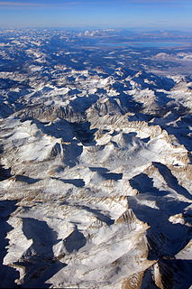
The Sierra Nevada is a mountain range in the Western United States, between the Central Valley of California and the Great Basin. The vast majority of the range lies in the state of California, although the Carson Range spur lies primarily in Nevada. The Sierra Nevada is part of the American Cordillera, a chain of mountain ranges that consists of an almost continuous sequence of such ranges that form the western "backbone" of North America, Central America, South America and Antarctica.
Vikingsholm is a 38-room mansion on the shore of Emerald Bay at Lake Tahoe, in El Dorado County, California, U.S., and on the National Register of Historic Places.
El Dorado, not to be confused with the nearby El Dorado Hills, is an unincorporated community in El Dorado County, California. It is located 4 miles (6.4 km) southwest of Placerville, at an elevation of 1608 feet. The population was 4,096 at the 2000 census. The town is registered as California Historical Landmark #486. The ZIP code is 95623. The community is inside area code 530.
Newtown is a small unincorporated community in El Dorado County, California, United States. It is located 2.25 miles (3.6 km) south of Camino, at an elevation of 2447 feet. The ZIP code is 95667. The community is inside area code 530.
Gold Ridge is an unincorporated community in El Dorado County, California. It lies at an elevation of 4045 feet.
Buckeye is an unincorporated community in El Dorado County, California. It is located 2.5 miles (4.0 km) east-northeast of Georgetown, at an elevation of 2949 feet.
Cedar Grove is an unincorporated community in El Dorado County, California. It lies at an elevation of 3386 feet.
Deer Park is an unincorporated community in El Dorado County, California. It lies at an elevation of 1755 feet.
Frenchtown is an unincorporated community in El Dorado County, California. It is located on French Creek 2 miles (3.2 km) south-southeast of Shingle Springs, at an elevation of 1165 feet.
Garden Valley is an unincorporated community in El Dorado County, California. It is located on Johntown Creek 6.25 miles (10 km) north-northwest of Chili Bar, at an elevation of 1949 feet.
Gold Hill is an unincorporated community in El Dorado County, California. It is located 2.5 miles (4.0 km) south of Coloma, at an elevation of 1621 feet.
Greenwood is an unincorporated community in El Dorado County, California. It is located 4 miles (6.4 km) west of Georgetown, at an elevation of 1608 feet.
Happy Valley is an unincorporated community in El Dorado County, California. It is located 7.25 miles (12 km) east-southeast of Camino, at an elevation of 3694 feet.
Morrison is an unincorporated community in El Dorado County, California. It lies at an elevation of 5279 feet. Morrison is located at 38°42′35″N120°19′28″W.
Onchomo is a former Maidu settlement in El Dorado County, California. It was located 5 miles (8 km) south of Placerville; the site is now covered by El Dorado.
Outingdale is an unincorporated community in El Dorado County, California. It is located on the Middle Fork of the Cosumnes River 4 miles (6.4 km) north of Aukum, at an elevation of 1624 feet.
Spanish Flat is an unincorporated community in El Dorado County, California. It is located 4 miles (6 km) north of Chili Bar, at an elevation of 2431 feet.
Spring Valley is an unincorporated community in El Dorado County, California. It is located 3 miles (4.8 km) east-northeast of Pollock Pines, at an elevation of 3779 feet.
Voss is an unincorporated community in El Dorado County, California. It lies at an elevation of 5499 feet. Voss is located at 38°39′26″N120°23′16″W.
Cummings is a former settlement in El Dorado County, California. It was located on the Southern Pacific Railroad 2 miles (3.2 km) west of El Dorado.
Aurum City is a former settlement in El Dorado County, California. It was located 2 miles (3.2 km) southeast of El Dorado.
Coordinates: 38°57′36″N120°05′53″W / 38.96000°N 120.09806°W
A geographic coordinate system is a coordinate system that enables every location on Earth to be specified by a set of numbers, letters or symbols. The coordinates are often chosen such that one of the numbers represents a vertical position and two or three of the numbers represent a horizontal position; alternatively, a geographic position may be expressed in a combined three-dimensional Cartesian vector. A common choice of coordinates is latitude, longitude and elevation. To specify a location on a plane requires a map projection.
This El Dorado County, California–related article is a stub. You can help Wikipedia by expanding it. |