Fornis (former settlement), California

Last updated
For the unincorporated community of this name, see Fornis, California.

Coordinates: 38°53′30″N120°35′00″W / 38.89167°N 120.58333°W / 38.89167; -120.58333

Geographic coordinate system Coordinate system

A geographic coordinate system is a coordinate system that enables every location on Earth to be specified by a set of numbers, letters or symbols. The coordinates are often chosen such that one of the numbers represents a vertical position and two or three of the numbers represent a horizontal position; alternatively, a geographic position may be expressed in a combined three-dimensional Cartesian vector. A common choice of coordinates is latitude, longitude and elevation. To specify a location on a plane requires a map projection.

Fornis
Former settlement
USA California location map.svg
Red pog.svg
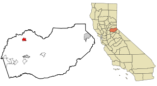
Fornis
Location in California
Coordinates: 38°53′30″N120°35′00″W / 38.89167°N 120.58333°W / 38.89167; -120.58333
Country United States
State California
County El Dorado County

Fornis is a former settlement in El Dorado County, California. [1] It was located 13 miles (21 km) east of Georgetown. [1]

El Dorado County, California County in California

El Dorado County, officially the County of El Dorado, is a county in the U.S. state of California. As of the 2010 census, the population was 181,058. The county seat is Placerville.

California State of the United States of America

California is a state in the Pacific Region of the United States. With 39.6 million residents, California is the most populous U.S. state and the third-largest by area. The state capital is Sacramento. The Greater Los Angeles Area and the San Francisco Bay Area are the nation's second and fifth most populous urban regions, with 18.7 million and 9.7 million residents respectively. Los Angeles is California's most populous city, and the country's second most populous, after New York City. California also has the nation's most populous county, Los Angeles County, and its largest county by area, San Bernardino County. The City and County of San Francisco is both the country's second-most densely populated major city after New York City and the fifth-most densely populated county, behind only four of the five New York City boroughs.

Georgetown, California census-designated place in California, United States

Georgetown is a census-designated place (CDP) in El Dorado County, California. It is the northeastern-most town in the California Mother Lode. The population was 2,367 at the 2010 census, up from 962 in 2000. The town is registered as California Historical Landmark #484.

Related Research Articles

Wheatland Reservoir

Wheatland Reservoir is the name of three reservoirs located near Wheatland in the U.S. State of Wyoming. Wheatland Reservoir Number 1 is located nearest to the town of Wheatland. It was formed by impounding Canal No 3 which is fed by Sybille Creek coming off the eastern slope of the Laramie Mountains. Wheatland Reservoir Number 2 is located on the western side of the Laramie Mountains. It was formed by impounding the Laramie River. Nearby Wheatland Reservoir Number 3 is fed by a canal from Reservoir Number 2 and the Laramie River.

Milton, California Unincorporated community in California, United States

Milton is an unincorporated community in Calaveras County, California. It lies at an elevation of 394 feet and is located at 38°01′55″N120°51′08″W. The community is in ZIP code 95684 and area code 209.

Douglas Flat, California Unincorporated community in California, United States

Douglas Flat is an unincorporated community in Calaveras County, California. It lies at an elevation of 1965 feet and is located at 38°06′52″N120°27′18″W. The community is in ZIP code 95229 and area code 209.

Jesus Maria, California Unincorporated community in California, United States

Jesus Maria is an unincorporated community in Calaveras County, California. It lies at an elevation of 1043 feet and is located at 38°17′08″N120°38′51″W. The community is in ZIP code 95222 and area code 209.

Paloma, California Unincorporated community in California, United States

Paloma is an unincorporated community in Calaveras County, California. It lies at an elevation of 1362 feet and is located at 38°15′34″N120°45′48″W. The community is in ZIP code 95252 and area code 209.

Freemark Abbey Winery

Freemark Abbey Winery, located between St. Helena and Calistoga in California's Napa Valley, traces its roots to 1886. Today, Freemark Abbey produces Cabernet Sauvignon, Merlot, Chardonnay, and Riesling, as well as very limited production wines, such as Viognier, Petite Sirah, Sangiovese, and Cabernet Franc. Depending on conditions, the winery sometimes makes a late harvest Riesling known as "Edelwein Gold".

Spipiyus Provincial Park is a 2,979 hectare provincial park in British Columbia, Canada. Also known as the Caren Range, Spipiyus Park is north of Halfmoon Bay on the Sechelt Peninsula. It protects pockets of old-growth forest, prime habitat for the marbled murrelet. There are hiking trails that lead to Mount Hallowell with views of the islands and fjords of Pender Harbour, the Strait of Georgia and Vancouver Island.

The Yurok Tribe of the Yurok Reservation' is located in parts of Del Norte and Humboldt counties, California, on a 44-mile (71 km) stretch of the Klamath River. It is a rancheria of Yurok people and a federally recognized tribe.

Cedar Vista, California Unincorporated community in California, United States

Cedar Vista is an unincorporated community in Calaveras County, California. It lies at an elevation of 3317 feet. Cedar Vista is located at 38°10′10″N120°24′29″W.

Hams, California Unincorporated community in California, United States

Hams is an unincorporated community in Calaveras County, California. It lies at an elevation of 2976 feet. Hams is located at 38°22′27″N120°27′44″W.

Brownsville is a former settlement in Calaveras County, California, about 1 mile east of Murphys. Brownsville, named for Alfred Brown, operated as a mining camp in the 1850s and 1860s.

Fornis, California Unincorporated community in California, United States

Fornis is an unincorporated community in El Dorado County, California. It is located 1.5 miles (2.4 km) southwest of Georgetown, at an elevation of 2379 feet.

Lower Forni, California Unincorporated community in California, United States

Lower Forni is an unincorporated community in El Dorado County, California. It is located 3.25 miles (5 km) west-southwest of Upper Forni, at an elevation of 6929 feet.

Morrison, California Unincorporated community in California, United States

Morrison is an unincorporated community in El Dorado County, California. It lies at an elevation of 5279 feet. Morrison is located at 38°42′35″N120°19′28″W.

Upper Forni, California Unincorporated community in California, United States

Upper Forni is an unincorporated community in El Dorado County, California. It is located 3.25 miles (5 km) east-northeast of Lower Forni, at an elevation of 7513 feet.

Voss, California Unincorporated community in California, United States

Voss is an unincorporated community in El Dorado County, California. It lies at an elevation of 5499 feet. Voss is located at 38°39′26″N120°23′16″W.

Cecil Lake human settlement in Canada

Cecil Lake is a settlement in British Columbia.

Unity, Adams County, Ohio human settlement in United States of America

Unity is an unincorporated community in Adams County, Ohio, United States.

Griswold Creek is a stream in San Benito County, California. Its head is at the confluence of Pimental Creek and Vallecitos Creek. From there it flows north-northeastward through the canyon between the Griswold Hills in the east, and Buck Peak in the Diablo Range on the west, to its mouth, located at an elevation of 1,145 feet (349 m) at its confluence with Panoche Creek 1.5 miles (2.4 km) southeast of Panoche in the Panoche Valley.

References

  1. 1 2 Durham, David L. (1998). California's Geographic Names: A Gazetteer of Historic and Modern Names of the State. Clovis, Calif.: Word Dancer Press. p. 486. ISBN   1-884995-14-4.