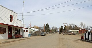
Short Place, California

Last updated

Coordinates: 38°46′48″N120°28′27″W / 38.78000°N 120.47417°W / 38.78000; -120.47417

Geographic coordinate system Coordinate system

A geographic coordinate system is a coordinate system that enables every location on Earth to be specified by a set of numbers, letters or symbols. The coordinates are often chosen such that one of the numbers represents a vertical position and two or three of the numbers represent a horizontal position; alternatively, a geographic position may be expressed in a combined three-dimensional Cartesian vector. A common choice of coordinates is latitude, longitude and elevation. To specify a location on a plane requires a map projection.

Short Place
Unincorporated community
California Locator Map with US.PNG
Red pog.svg
Short Place
Location in California
Usa edcp location map.svg
Red pog.svg
Short Place
Short Place (the US)
Coordinates: 38°46′48″N120°28′27″W / 38.78000°N 120.47417°W / 38.78000; -120.47417
Country United States
State California
County El Dorado County
Elevation [1] 3,576 ft (1,090 m)

Short Place is an unincorporated community in El Dorado County, California. [1] It lies at an elevation of 3576 feet (1090 m). [1]

Unincorporated area Region of land not governed by own local government

In law, an unincorporated area is a region of land that is not governed by a local municipal corporation; similarly an unincorporated community is a settlement that is not governed by its own local municipal corporation, but rather is administered as part of larger administrative divisions, such as a township, parish, borough, county, city, canton, state, province or country. Occasionally, municipalities dissolve or disincorporate, which may happen if they become fiscally insolvent, and services become the responsibility of a higher administration. Widespread unincorporated communities and areas are a distinguishing feature of the United States and Canada. In most other countries of the world, there are either no unincorporated areas at all, or these are very rare; typically remote, outlying, sparsely populated or uninhabited areas.

El Dorado County, California County in California

El Dorado County, officially the County of El Dorado, is a county in the U.S. state of California. As of the 2010 census, the population was 181,058. The county seat is Placerville.

California State of the United States of America

California is a state in the Pacific Region of the United States. With 39.6 million residents, California is the most populous U.S. state and the third-largest by area. The state capital is Sacramento. The Greater Los Angeles Area and the San Francisco Bay Area are the nation's second and fifth most populous urban regions, with 18.7 million and 8.8 million residents respectively. Los Angeles is California's most populous city, and the country's second most populous, after New York. California also has the nation's most populous county, Los Angeles County, and its largest county by area, San Bernardino County. The City and County of San Francisco is both the country's second-most densely populated major city after New York and the fifth-most densely populated county, behind only four of the five New York City boroughs.

Related Research Articles

Salton Sea State Recreation Area

Located on the northeastern side of the Salton Sea, the Salton Sea State Recreation Area offers hunting, fishing, swimming, and camping to visitors.

Jenny Lind, California Unincorporated community in California, United States

Jenny Lind is an unincorporated community in Calaveras County, California. It lies at an elevation of 253 feet and is located at 38°6′N120°52′W. The community is in ZIP code 95252 and area code 209.

Glencoe, California Unincorporated community in California, United States

Glencoe is an unincorporated community in Calaveras County, California. It lies at an elevation of 2749 feet and is located at 38°21′15″N120°35′06″W. The community is in ZIP code 95232 and area code 209.

Jesus Maria, California Unincorporated community in California, United States

Jesus Maria is an unincorporated community in Calaveras County, California. It lies at an elevation of 1043 feet and is located at 38°17′08″N120°38′51″W. The community is in ZIP code 95222 and area code 209.

Paloma, California Unincorporated community in California, United States

Paloma is an unincorporated community in Calaveras County, California. It lies at an elevation of 1362 feet and is located at 38°15′34″N120°45′48″W. The community is in ZIP code 95252 and area code 209.

Badr is a town in Al Madinah Province, Al-Hijaz, Saudi Arabia. It is located at around 23°46′48″N38°47′26″E, and about 130 km (81 mi) from the Islamic holy city of Medina. It was the location of the famous Battle of Badr, between the Quraishi-led Polytheists, and the Muslims under the leadership of Muhammad, in 624 CE.

Lazear, Colorado Unincorporated community in Colorado, United States

Lazear is an unincorporated community and a U.S. Post Office located in Delta County, Colorado, United States. The Lazear Post Office has the ZIP Code 81420.

Kellys Ford, Virginia

Kelly's Ford was a major crossing point on the Rappahannock River. It was the site of a Civil War battle for control of the river ford. Today it is the only crossing on the river between Fredericksburg and Remington. It is the location of the Inn at Kelly's Ford and the Kelly's Ford Equestrian Center. It is also a frequently used launch point for canoe trips down the mostly untouched river.

Camp Roberts, California

Camp Roberts is a California National Guard post in central California, located on both sides of the Salinas River in Monterey and San Luis Obispo counties, now run by the California Army National Guard. It was opened in 1941 and is named after Corporal Harold W. Roberts, a World War I Medal of Honor recipient. Nearby communities include San Miguel, Heritage Ranch, Oak Shores, and Bradley, all unincorporated. The nearest incorporated city is Paso Robles. Camp Roberts is roughly 25 miles southeast of Fort Hunter Liggett.

Lava Beds, California Former settlement in California, United States

Lava Beds is a former settlement in Butte County, California. It lay at an elevation of 151 feet. It remained on maps as late as 1895. It was a community of Chinese miners, located near Pacific Heights, 2.5 miles (4.0 km) north-northwest of Palermo.

Bummerville, California Unincorporated community in California, United States

Bummerville is an unincorporated community in Calaveras County, California, about 1 mile east of West Point. It has frequently been noted on lists of unusual place names. It lies at an elevation of 898 m and is located at 38°24′05″N120°30′21″W.

Fisher Place, California Unincorporated community in California, United States

Fisher Place is an unincorporated community in Calaveras County, California. It lies at an elevation of 2677 feet.

McKay, Calaveras County, California Unincorporated community in California, United States

McKay is an unincorporated community in Calaveras County, California. It lies at an elevation of 4180 feet. It is a populated place Located within the Arnold CDP.

Bullard, California Unincorporated community in California, United States

Bullard is an unincorporated community in El Dorado County, California. It is located on the Southern Pacific Railroad 3.5 miles (5.6 km) north-northeast of Latrobe, at an elevation of 1122 feet.

Caldor, California Unincorporated community in California, United States

Caldor is an unincorporated community in El Dorado County, California. It lies at an elevation of 4442 feet. Caldor was linked to Diamond Springs by the Diamond and Caldor Railway. The community was named for the California Door Company.

Frenchtown, El Dorado County, California Unincorporated community in California, United States

Frenchtown is an unincorporated community in El Dorado County, California. It is located on French Creek 2 miles (3.2 km) south-southeast of Shingle Springs, at an elevation of 1165 feet.

Jones Place, California Unincorporated community in California, United States

Jones Place is an unincorporated community in El Dorado County, California. It lies at an elevation of 4921 feet.

McConnel Place, California Unincorporated community in California, United States

McConnel Place is an unincorporated community in El Dorado County, California. It lies at an elevation of 4600 feet.

Nashville, California Unincorporated community in California, United States

Nashville is an unincorporated community in El Dorado County, California. It is located on the North Fork of the Cosumnes River 10.5 miles (17 km) south of Placerville, at an elevation of 863 feet.

Potts is an unincorporated community in Osage County, in the U.S. state of Missouri. Potts is located on U.S. Route 50 between Linn to the west and Mount Sterling to the east, in Gasconade County.

References