Oak Tree Village, California

Last updated

Coordinates: 38°42′25″N121°04′31″W / 38.70694°N 121.07528°W / 38.70694; -121.07528

Geographic coordinate system Coordinate system

A geographic coordinate system is a coordinate system that enables every location on Earth to be specified by a set of numbers, letters or symbols. The coordinates are often chosen such that one of the numbers represents a vertical position and two or three of the numbers represent a horizontal position; alternatively, a geographic position may be expressed in a combined three-dimensional Cartesian vector. A common choice of coordinates is latitude, longitude and elevation. To specify a location on a plane requires a map projection.

Oak Tree Village
Unincorporated community
California Locator Map with US.PNG
Red pog.svg
Oak Tree Village
Location in California
Usa edcp location map.svg
Red pog.svg
Oak Tree Village
Oak Tree Village (the US)
Coordinates: 38°42′25″N121°04′31″W / 38.70694°N 121.07528°W / 38.70694; -121.07528
Country United States
State California
County El Dorado County
Elevation [1] 646 ft (197 m)

Oak Tree Village is an unincorporated community in El Dorado County, California. [1] It lies at an elevation of 646 feet (197 m). [1]

Unincorporated area Region of land not governed by own local government

In law, an unincorporated area is a region of land that is not governed by a local municipal corporation; similarly an unincorporated community is a settlement that is not governed by its own local municipal corporation, but rather is administered as part of larger administrative divisions, such as a township, parish, borough, county, city, canton, state, province or country. Occasionally, municipalities dissolve or disincorporate, which may happen if they become fiscally insolvent, and services become the responsibility of a higher administration. Widespread unincorporated communities and areas are a distinguishing feature of the United States and Canada. In most other countries of the world, there are either no unincorporated areas at all, or these are very rare; typically remote, outlying, sparsely populated or uninhabited areas.

El Dorado County, California County in California

El Dorado County, officially the County of El Dorado, is a county in the U.S. state of California. As of the 2010 census, the population was 181,058. The county seat is Placerville.

California State of the United States of America

California is a state in the Pacific Region of the United States. With 39.6 million residents, California is the most populous U.S. state and the third-largest by area. The state capital is Sacramento. The Greater Los Angeles Area and the San Francisco Bay Area are the nation's second- and fifth-most populous urban regions, with 18.7 million and 9.7 million residents respectively. Los Angeles is California's most populous city, and the country's second-most populous, after New York City. California also has the nation's most populous county, Los Angeles County, and its largest county by area, San Bernardino County. The City and County of San Francisco is both the country's second-most densely populated major city after New York City and the fifth-most densely populated county, behind only four of the five New York City boroughs.

Related Research Articles

Sunol Regional Wilderness regional park

The Sunol Regional Wilderness is a regional park in Alameda County, the eastern San Francisco Bay Area, Northern California. It is located near the town of Sunol, south of Pleasanton and east of Fremont.

Uvas Canyon County Park

Uvas Canyon County Park is a 1,147-acre (464 ha) natural park located in upper Uvas Canyon on the eastern side of the Santa Cruz Mountains, west of Morgan Hill, California. The park has several small waterfalls, some of which flow perennially, that feed into tributaries confluent with Uvas Creek. The park is part of the Santa Clara County Parks System, and facilitates picnics, hiking and overnight camping. It is one of the few parks in the area that allows dogs in the campgrounds.

Area code 209 area codes in the United States

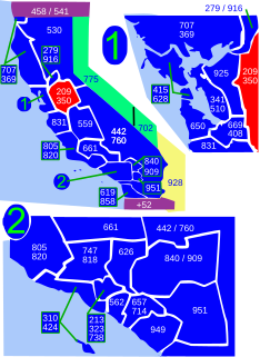
Area code 209 is the California telephone area code that was split from area code 415 on October 26, 1957. It covers Stockton, Modesto, Turlock, Merced, Winton, Atwater, Livingston, Manteca, Ripon, Tracy, Lodi, Galt, Sonora, Los Banos, San Andreas, Mariposa, and Yosemite, the northern San Joaquin Valley, and the Sierra Foothills.

Orell is a neighborhood of Louisville, Kentucky centered along Dixie Highway and Orell Road.

Santos-o-Velho is a former freguesia of Lisbon, Portugal, with an area of 0.51 km2 and 4,013 inhabitants (2001). It has a population density of 7899.6 inhabitants/km2. At the administrative reorganization of Lisbon on 8 December 2012 it became part of the parish Estrela.

Czernica, Silesian Voivodeship Village in Silesian, Poland

Czernica is a village in the administrative district of Gmina Gaszowice, within Rybnik County, Silesian Voivodeship, in southern Poland. It lies approximately 5 kilometres (3 mi) south-west of Gaszowice, 11 km (7 mi) west of Rybnik, and 47 km (29 mi) south-west of the regional capital Katowice. The village has an approximate population of 2,100, and covers an area of 5.18 km2. It is the birthplace of the composer Henryk Górecki.

Oak Grove, Butte County, California Unincorporated community in California, United States

Oak Grove is an unincorporated community in Butte County, California. It lies at an elevation of 128 feet.

Cambridge Oaks, California Unincorporated community in California, United States

Cambridge Oaks is an unincorporated community in El Dorado County, California. It lies at an elevation of 1158 feet.

Franciscan Village, El Dorado County, California Unincorporated community in California, United States

Franciscan Village is an unincorporated community in El Dorado County, California. It lies at an elevation of 722 feet.

Governors Village, California Unincorporated community in California, United States

Governors Village is an unincorporated community in El Dorado County, California. It lies at an elevation of 751 feet.

Hidden Valley, El Dorado County, California Unincorporated community in California, United States

Hidden Valley is an unincorporated community in El Dorado County, California. It lies at an elevation of 515 feet.

Lakeridge Oaks, California Unincorporated community in California, United States

Lakeridge Oaks is an unincorporated community in El Dorado County, California. It lies at an elevation of 476 feet.

Marina Village, California Unincorporated community in California, United States

Marina Village is an unincorporated community in El Dorado County, California. It lies at an elevation of 692 feet.

Oak Creek Hills, California Unincorporated community in California, United States

Oak Creek Hills is an unincorporated community in El Dorado County, California. It lies at an elevation of 591 feet.

Oak Ridge Village, California Unincorporated community in California, United States

Oak Ridge Village is an unincorporated community in El Dorado County, California. It lies at an elevation of 804 feet.

Sierra Springs, California Unincorporated community in California, United States

Sierra Springs is an unincorporated community in El Dorado County, California. It lies at an elevation of 3323 feet.

Stonegate Village, California Unincorporated community in California, United States

Stonegate Village is an unincorporated community in El Dorado County, California. It lies at an elevation of 745 feet.

Summit Village, California Unincorporated community in California, United States

Summit Village is an unincorporated community in El Dorado County, California. It lies at an elevation of 633 feet.

Waterford Village, California Unincorporated community in California, United States

Waterford Village is an unincorporated community in El Dorado County, California. It lies at an elevation of 669 feet.

Cedarbrook, California Unincorporated community in California, United States

Cedarbrook is an unincorporated community in Fresno County, California. It is located 6.5 miles (10 km) east-southeast of Dunlap, at an elevation of 4193 feet.

References